geo.wikisort.org - Reservoir
Following is a list of dams and reservoirs in Puerto Rico.
The below list is incomplete. The National Inventory of Dams, maintained by the U.S. Army Corps of Engineers, defines any "major dam" as being 50 feet (15 m) tall with a storage capacity of at least 5,000 acre-feet (6,200,000 m3), or of any height with a storage capacity of 25,000 acre-feet (31,000,000 m3).[1]
Dams and reservoirs in Puerto Rico

- This list is incomplete. You can help Wikipedia by expanding it.
- Lago Caonillas, Utuado, Puerto Rico Electric Power Authority (PREPA)
- Carite Lake, Guayama, PREPA
- Carraízo Dam and Lago Loíza, Trujillo Alto, Puerto Rico Aqueducts and Sewers Authority (PRASA)
- Lake Cerrillos Dam, Ponce, United States Army Corps of Engineers
- Lago de Cidra, Cidra, PRASA
- Coamo Dam, between Coamo and Santa Isabel, PREPA
- Dos Bocas Lake, between Arecibo and Utuado municipalities, PREPA
- Guajataca Lake, between San Sebastián, Quebradillas and Isabela municipalities, PREPA
- Lago Guayabal, Juana Díaz, PREPA
- Lago el Guineo (Rio Toro Negro), Villalba, PREPA[2]
- Garzas, Peñuelas, PREPA [3]
- Lago La Plata, Toa Alta, PRASA
- Patillas Dam, Patillas, PREPA[4]
- Portugués Dam, Ponce, USACE
- Rio Blanco Project, Naguabo, PREPA[3]
- El Salto #1 and El Salto #2, Comerío
- Lago Toa Vaca, Villalba, PRASA
- Yauco Project, Yauco, PREPA[3]
Gallery
 Dos Bocas Lake with dam in Puerto Rico
 Lago Caonillas
 Carraízo Dam
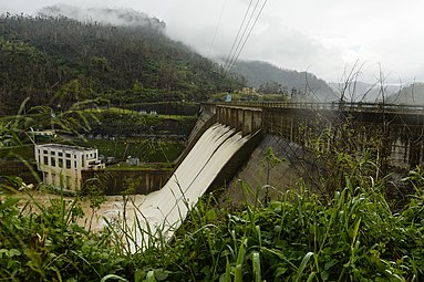 Lago Dos Bocas Dam after Hurricane Maria
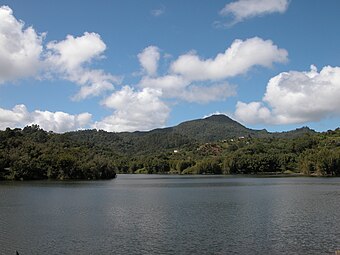 Lago Patillas


References
- "Major Dams of the United States". USGS National Map. Retrieved 24 September 2017.
- "LAGO EL GUINEO AT DAMSITE NEAR VILLALBA, PR". USGS National Water Information System. Retrieved 17 September 2020.
- "Puerto Rico Electric Power Hydroelectric Power Plants Revitalization Project (RFQ 2019-2), Government of Puerto Rico, Request for Qualification, (April 16, 2019)" (PDF). Puerto Rico Fiscal Agency and Financial Advisory Authority. Retrieved 17 September 2020.
- "Sedimentation Survey of Lago Patillas, Puerto Rico, March 2007" (PDF). USGS. Retrieved 21 July 2020.
External links
Текст в блоке "Читать" взят с сайта "Википедия" и доступен по лицензии Creative Commons Attribution-ShareAlike; в отдельных случаях могут действовать дополнительные условия.
Другой контент может иметь иную лицензию. Перед использованием материалов сайта WikiSort.org внимательно изучите правила лицензирования конкретных элементов наполнения сайта.
Другой контент может иметь иную лицензию. Перед использованием материалов сайта WikiSort.org внимательно изучите правила лицензирования конкретных элементов наполнения сайта.
2019-2026
WikiSort.org - проект по пересортировке и дополнению контента Википедии
WikiSort.org - проект по пересортировке и дополнению контента Википедии