geo.wikisort.org - Reservoir
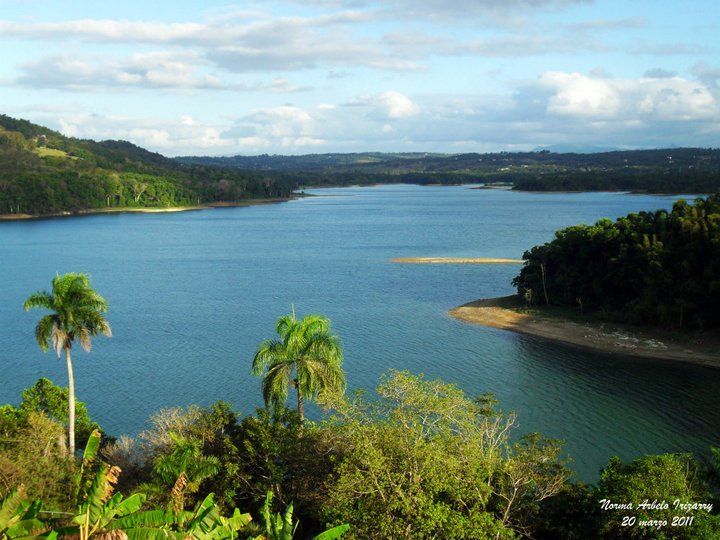
Guajataca Lake, or Lago Guajataca, is a reservoir of the Guajataca River created by the Puerto Rico Electric Power Authority in 1929. It is located between the municipalities of San Sebastián, Quebradillas, and Isabela in Puerto Rico,[3][4] and receives most of its water from the Rio Guajataca and Rio Chiquito de Cibao rivers. The lake primarily functions as a water reservoir as well as for recreational activities such as boating and fishing.[5][6] Various species of fish such as peacock bass, largemouth bass, sunfish, perch, catfish, tilapia and threadfin shad can be found in the lake.[7] The Guajataka Scout Reservation partially borders the southern portion of the lake. The dam at Guajataca Lake experienced a structural failure on September 22, 2017, due to the hit from Hurricane Maria.[8][9][10]
| Guajataca Lake | |
|---|---|
 | |
 Guajataca Lake | |
| Location | San Sebastián / Quebradillas / Isabela municipalities, Puerto Rico |
| Coordinates | 18°23′51″N 66°55′26″W |
| Type | Reservoir |
| Native name | Lago Guajataca (Spanish) |
| Basin countries | Puerto Rico |
| Managing agency | Puerto Rico Electric Power Authority |
| Built | 1928[1] |
| First flooded | 1928[1] |
| Surface area | 1.32 square miles (3.4 km2)[1] |
| Water volume | 11,000,000,000 US gal (42,000,000 m3)[2] |
The reservoir is considered a touristic area.[11]
Guajataca Dam
| Guajataca Dam | |
|---|---|
 The dam in August 2007 | |
| Purpose | Irrigation, Water Supply[2] |
| Owner(s) | Puerto Rico Electric Power Authority[12] |
| Operator(s) | Puerto Rico Electric Power Authority[12] |
| Dam and spillways | |
| Type of dam | Earthen[12] |
| Height (thalweg) | 120 (feet)[12] |
| Length | 984 (feet)[12] |
| Reservoir | |
| Creates | Guajataca Lake |
The Guajataca Dam is an earthen dam[12] is currently used for irrigation and potable water purposes. A hydroelectric power station was built, but not longer in use.[13] The reservoir has a normal surface area of 1.6 square miles (4.1 square kilometres), its length is 2.5 miles (4.0 kilometres), its maximum width is 1 mile (1.6 kilometres), and its maximum discharge is 28,954 cubic feet (819.9 cubic metres) per second. Its normal storage capacity is 30,055 acre-feet (37 million cubic metres), and its drainage basin is 31 square miles (80 km2).[14][better source needed]
Dam construction
The construction of the dam was authorized by act 63 of the Legislature of Puerto Rico, known as the "Isabela public irrigation law," approved April 19, 1919.[15]
The dam was constructed starting in 1928. The reservoir had an initial storage capacity of 39,286 acre-feet (48 million cubic metres), but by 1999 (71 years later), the capacity had been reduced to 34,276 acre-feet (42 million cubic metres), as about 13% less, attributed to sediment erosion.[8] The surface area of the reservoir was 3.42 km2 (1.32 sq mi) in 1999.[1]
According to the National Inventory of Dams, Guajataca Dam was designed by and is owned by the Puerto Rico Electric Power Authority.[12]
Guajataca dam failure risk
On September 22, 2017, at 18:10 GMT, following Hurricane Maria, operators at Guajataca Dam announced that the dam's spillway was failing at the northern end of the lake and it could result in the whole dam collapsing.[16] The National Weather Service a few minutes later urged all 70,000 residents in the flood area to be evacuated. The National Weather Service stated the dam was a "life-threatening situation".[17][18][19] "It’s a structural failure. I don’t have any more details," Governor Ricardo Rosselló stated. "We’re trying to evacuate as many people as possible."[19] Rosselló ordered the Puerto Rico National Guard and the Police to help assist in the evacuation effort downstream.[20] The dam lies across the Guajataca River to form a reservoir that can hold roughly 11 billion gallons of water.[21]
As of September 2017[update], the dam was last inspected on October 23, 2013.[12]
The first phase of repairs to avoid the threat of flooding were completed on November 17, 2017. Since then about 10,000 residents, including farmers, who depend on the waters of the reservoir, have been struggling with the rationing of water. There is confusion and little transparency as to how the issue is being handled. Final repairs will be ongoing, until 2028.[22][23]
Gallery
 Lake Guajataca in San Sebastián
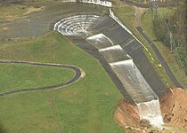 Damaged spillway, September 27
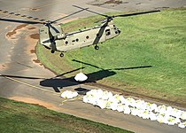 Pennsylvania National Guard working to stabilize the structure
 A Chinook lifting a big sandbag to reinforce the spillway, October 9
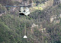 Pennsylvania National Guard
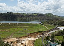 USACE and Pennsylvania National Guard working to stabilize the structure, October 9


See also
References
- Luis R. Soler-López1 (2001). "SEDIMENTATION SURVEY RESULTS of the Principal Water-Supply Reservoirs of Puerto Rico". pr.water.usgs.gov. U.S. Geological Survey. USGS Water Resources of the Caribbean. TABLE 1. Results of bathymetric surveys of 14 reservoirs in Puerto Rico. Retrieved 2017-09-22.
- Puerto Rico Dam Failing; Flash Flood Emergency Declared: "This is an EXTREMELY DANGEROUS SITUATION," NWS San Juan said in a tweet. Asher Klein. NBC10-TV. Philadelphia, Pennsylvania, USA. 22 September 2017. Access 22 September 2017.
- "Lake Guajataca". Atlas Obscura. Retrieved 2021-12-30.
- "Lago Guajataca". pr.gov - Quebradillas. Retrieved 2021-12-30.
- "Un pasadía en... Lago Guajataca". Primera Hora. July 2015. Retrieved 2021-12-30.
- "Refugio Vida Silvestre, Embalse Guajataca". Discover Puerto Rico. Retrieved 2021-12-30.
- "Lago Guajataca". 3 May 2013. Retrieved 2022-02-10.
- "Lago Guajataca at Damsite". Water Resources of the Caribbean. United States Geological Survey. Retrieved September 22, 2017.
- Ellis, Ralph (22 September 2017). "Puerto Rico dam: Evacuations begin along Guajataca River". CNN. CNN News. Retrieved September 22, 2017.
- Schmidt, Samantha. "'Thousands of people could die': 70,000 in Puerto Rico urged to evacuate with dam in 'imminent' danger". Washington Post. Retrieved September 23, 2017.
- "El embalse Guajataca entraría en nivel de ajustes operacionales este jueves o viernes". 22 June 2022.
- GUAJATACA DAM: NID Detail Report
- "Fotografias de Plantas Hidroelectricas en el 2013". Recursos Agua Puerto Rico. Retrieved 2021-12-30.
- "National Pollutant Discharge Elimination System (NPDES) Phase II, Regulated Small Municipal Separate Storm Sewer System (MS4's) Permit Application Notice of Intent (NOI)" (PDF). U.S. Environmental Protection Agency- Region II. January 2010: 8. Retrieved 23 September 2017.
{{cite journal}}: Cite journal requires|journal=(help) This article incorporates text from this source, which is in the public domain.
 - Reily, Emmet Montgomery, Governor of Puerto Rico (1922). Annual Report. U.S. Government Printing Office. pp. 233–234.
{{cite book}}: CS1 maint: multiple names: authors list (link) - "Aid reaches Puerto Rico after Maria as threat from cracked dam recedes". The Guardian. 24 September 2017. Retrieved September 26, 2017.
- "Guajataca Dam fails in Puerto Rico, prompting "extremely dangerous" situation". CBS News. Retrieved September 22, 2017.
- "Puerto Rico dam failure "imminent" after Hurricane Maria". BBC World News. BBC News. Retrieved September 22, 2017.
- "Puerto Rico evacuates 70,000 after dam fails in Hurricane Maria's wake". The Guardian. 22 September 2017. Retrieved September 22, 2017.
- Talmazan, Yuliya. "Puerto Rico's Failing Guajataca Dam Endangers Thousands". NBC News. Retrieved September 23, 2017.
- "Damage Assessments, Power Restoration Efforts Begin in Puerto Rico, Virgin Islands". The Weather Channel. Retrieved 2017-09-25.
- "Government of Puerto Rico Drained the Guajataca Dam at the Height of the Drought". 24 April 2019.
- "Drying Caribbean | Centro de Periodismo InvestigativoCentro de Periodismo Investigativo".
Authority control | |
|---|---|
| General |
|
| National libraries | |
| Other | |
На других языках
[de] Guajataca-Stausee
Der Guajataca-Stausee ist ein Stausee in Puerto Rico.- [en] Guajataca Lake
[es] Lago Guajataca
Lago Guajataca[1] es un embalse ubicado entre los municipios de San Sebastián, Quebradillas e Isabela, en el Estado libre asociado de Puerto Rico.[2] Este lago artificial fue creado en 1929. El lago recibe el flujo desde el río Guajataca y se puede utilizar para la pesca. El embalse abastece de agua a los habitantes del noroeste de Puerto Rico. Es también donde se ubica al Campamento Guajataka, el principal lugar en la isla para los campamentos de los Boy Scouts de América. La zona del lago es 10 grados más fría que el resto de la isla y ofrece oportunidades durante todo el año y actividades recreativas al aire libre como la pesca de róbalo, tilapia y bagre, kayak, observación de la naturaleza y relajación en general. El nombre del lago proviene de la zona donde se encuentra: Guajataca, a veces escrito Guajataka, es un área en Puerto Rico entre los municipios de Quebradillas, San Sebastián e Isabela. El nombre viene de la palabra taína para la zona (noroeste de Puerto Rico) antes de la llegada de Cristóbal Colón. El río Guajataca, también lleva ese nombre.[it] Lago Guajataca
Il Lago Guajataca è un lago del fiume Guajataca creato dalla Puerto Rico Electric Power Authority nel 1929. Esso si trova tra i comuni di San Sebastián, Quebradillas e Isabela in Porto Rico,[1][2] e riceve la maggior parte delle sue acque dai fiumi Rio Guajataca e Rio Chiquito de Cibao. Il lago funge principalmente come riserva d'acqua, ma viene utilizzato anche per attività ricreative quali canottaggio e pesca.[3][4] Nel lago si possono trovare varie specie di pesci quali Cichla, persico trota, persico sole, perca, pesce gatto, Tilapia e Dorosoma petenense.[5] La Guajataka Scout Reservation confina parzialmente con la parte sud del lago. La diga al lago Guajataca subì un cedimento strutturale il 22 settembre 2017, essendo stata colpita dall'Uragano Maria.[6][7][8]Другой контент может иметь иную лицензию. Перед использованием материалов сайта WikiSort.org внимательно изучите правила лицензирования конкретных элементов наполнения сайта.
WikiSort.org - проект по пересортировке и дополнению контента Википедии