geo.wikisort.org - Reservoir
Saint Anthony Falls, or the Falls of Saint Anthony (Dakota: Owámniyomni, lit. 'whirlpool'[3]) located at the northeastern edge of downtown Minneapolis, Minnesota, is the only natural major waterfall on the Mississippi River. Throughout the mid-to-late 1800’s, various dams were built atop the east and west faces of the falls to support the milling industry that spurred the growth of the city of Minneapolis. In 1880, the central face of the falls was reinforced with a sloping timber apron to stop the upstream erosion of the falls. In the 1950s, the apron was rebuilt with concrete, which makes up the most visible portion of the falls today. A series of locks were constructed in the 1950s and 1960s to extend navigation to points upstream.[4]
| Saint Anthony Falls | |
|---|---|
 Saint Anthony Falls with the upper lock and dam, viewed from downstream | |
 | |
| Location | Mississippi River into the Mississippi River Gorge in Minneapolis, Minnesota |
| Coordinates | 44°58′54″N 93°15′31″W |
| Type | Block |
| Total height | 49 ft (15 m) |
| Number of drops | 1 |
| Watercourse | Mississippi River |
| Average flow rate | 13,000 cu ft/s (370 m3/s) |
St. Anthony Falls Historic District[1] | |
U.S. National Register of Historic Places | |
U.S. Historic district | |
 | |
| Location | Minneapolis, Minnesota |
| NRHP reference No. | 71000438[2] |
| Added to NRHP | March 11, 1971 |
The falls were renamed from their Dakota title in 1680 by Father Louis Hennepin after his patron saint, St. Anthony of Padua. The towns of St. Anthony and Minneapolis, which had developed on the east and west sides of the falls, respectively, merged in 1872 to fully use the power of the falls for milling operations. From 1880 to about 1930, Minneapolis was known as the "Flour Milling Capital of the World".[5]


Today, the falls are defined by the spillway, the upper dam and the locks, located just downstream of the 3rd Avenue Bridge, and the Lower Lock and Dam, just upstream of the I-35W Saint Anthony Falls Bridge.[6] These locks were built as part of the Upper Mississippi River 9-Foot Navigation Project. The area around the falls is designated the St. Anthony Falls Historic District[7] and features a 1.8-mile (2.9 km) self-guided walking trail with signs explaining the area's past.
History

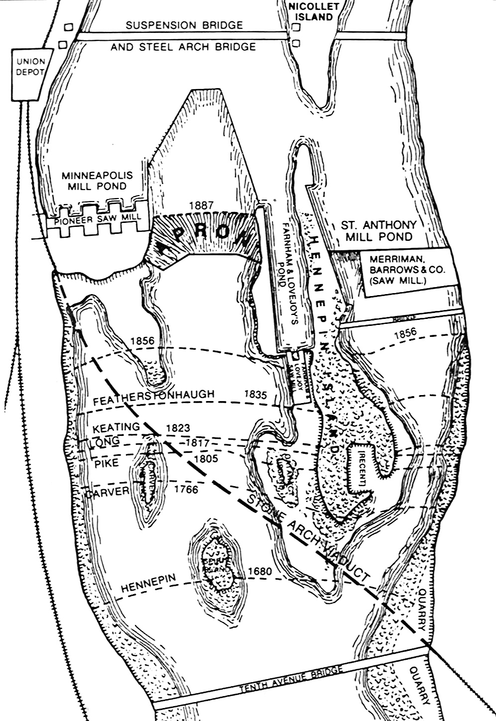
The falls hold cultural and spiritual significance for native tribes who frequented and lived in the area. The falls is an important and sacred site to the Mdewakanton Dakota and they called the Mississippi River, hahawakpa, "river of the falls". The falls (Haha) themselves were given specific names, mnirara "curling waters", owahmenah "falling waters", or owamni, "whirlpool" (mniyomni in the Eastern Dakota dialect and owamniyomni in the Teton Dakota (Lakota) dialect).[8] Dakota associate the falls with legends and spirits, including Oanktehi, god of waters and evil, who lived beneath the falling water.[9] The sacred falls also enters into their oral tradition by a story of a warrior's first wife who killed herself and their two children in anguish and forlorn love for the husband who had assumed a second wife.[10] The rocky islet where the woman had pointed her canoe toward doom thus was named Spirit Island which was once a nesting ground for eagles that fed on fish below the falls. Dakota camped on Nicollet Island upstream of the falls to fish and to tap the sugar maple trees.[11]

Since the cataract had to be portaged, the area became one of the natural resting and trade points along the Mississippi between Dakota and Anishinaabe peoples. The Anishinaabe (Ojibwe) term was recorded as "kakabikah" (gakaabikaa, "split rock" or more descriptively, gichi-gakaabikaa, "the great severed rock" which referenced the jagged chunks of limestone constantly eroding by the falls).[8][12]
In 1680, the falls became known to the Western world when they were observed and published in a journal by Father Louis Hennepin, a Catholic friar of Belgian birth, who had earlier brought the Niagara Falls to the world's attention via a publication.[13] Hennepin named them the Chutes de Saint-Antoine or the Falls of Saint Anthony after his patron saint, Anthony of Padua.[13][14] Later explorers to document the falls include Zebulon Montgomery Pike and Jonathan Carver, the first Englishman to undertake an exploration of the west. According to the John Carter Brown Library, "Carver's purpose was to map the land, to befriend the native Americans, and to discover the Northwest passage. His journey began in 1766 and, in some ways, was the precursor of the Lewis and Clark expedition; his book was the first popular American travel book."[15] Carver created this early image, an engraving of the falls, in 1778.

Following the establishment of Fort Snelling in 1820, the falls became an attraction for tourists, writers, and artists who sought inspiration even if Hennepin's descriptions were not as majestic as hoped for. By the 1860s, industrial waste had filled the area and marred the falls' majesty.[9] Further competition over the power of the falls on both banks of the river led to the Eastman tunnel disaster in 1869 which could have destroyed the falls. The disaster was fixed with a dike under the falls.
Industry
The first private land claim at the falls was made by Franklin Steele in 1838 — though he did not obtain financing for development until 1847, in the form of $12,000 for a nine-tenths stake in the property. On May 18, 1848, President James K. Polk approved the claims made in St. Anthony, and Steele was able to build his dam on the east side of the river above the Falls, blocking the east channel.

The dam extended diagonally into the river 700 feet (210 m), was 16 feet (4.9 m) high, and was secured to the limestone riverbed. Its thickness tapered from 40 wide at its base to 12 feet (3.7 m) wide at the top. Steele dispatched logging crews to the Crow Wing River in December 1847 to supply pine for the sawmill, and by September 1, 1848, sawing commenced using two up-down saws. He was able to sell the lumber readily, supplying construction projects in the booming town.[16] The new community at the Falls attracted entrepreneurs from New England, many of whom had experience in lumber and milling. He had hired Ard Godfrey to help build and run the first commercial sawmill at the Falls. Godfrey knew the most efficient ways to use natural resources, like the falls, and the great pine forests, to make lumber products.[17] Godfrey built the first home in St. Anthony, Steele had the town platted in 1849, and it incorporated in 1855.[18][19]

By 1854, 300 squatters occupied the west bank of the river, and in 1855, Congress recognized the squatters' right to purchase the land they had claimed. The west side quickly developed scores of new mills and consortia. They built a dam diagonally into the river to the north, which, along with Steele's dam created the inverted V-shape, still apparent today. Steele created the St. Anthony Falls Water Power Company in 1856 with three New York financiers, Davis, Gebhard, and Sanford. The company struggled for several years, due to poor relations with the financiers, a depression, and the Civil War. In 1868, the firm reorganized with new officers including John Pillsbury, Richard and Samuel Chute, Sumner Farnham, and Frederick Butterfield.[16]

As Minneapolis (and its former neighbor across the river, St. Anthony) developed, the water power at the falls became a source of power for several industries including textile mills, wool, machinery, paper, and wood products, of which the North Star Woolen Mill was successful. Sawmills made the falls a major lumber producing area, with the mills largely built on platforms above the limestone cap forming the falls. But the dominant industry became flour milling.
The falls industrialization was also a problem. Logs, sometimes a hundred at a time, escaped from log booms and hammered the falls. Diversion of water left parts of the limestone cap dry, increasing weathering effects. Shafts and tunnels from sawmills and other users weakened the limestone and its sandstone foundation, accelerating the falls' upriver erosion to 26 feet (7.9 m) per year between 1857 and 1868. The falls quickly approached the edge of the limestone cap; once the limestone had completely eroded away, the falls would degenerate into sandstone rapids unsuitable for waterpower.[9] To protect the falls and stop upstream progression a protective wood timber apron was built from the edge of the falls sloping downstream. The apron dissipated the energy of the falling water and moved it away from the base of the falls. It also protected from errant logs. An apron built in 1866 lasted until 1867. The Corps of Engineers completed one in 1880 that lasted until destroyed in 1952.[20] It was replaced with a concrete apron.[21]
The usual flour milling techniques did not work well for "spring wheat", which is the only kind that could be dependably grown on the rapidly expanding wheat farms in Minnesota and the Dakotas. In the late 1860s, major milling innovations at the falls were a "middlings purifier" and "gradual-reduction" grinding, both borrowed from Europe. Metal rollers replaced grindstones. The changes not only solved the spring wheat problem but produced high quality flour in a milling process that was highly profitable.[22][23] As the result of the new technology, flour mills began to dominate the falls after 1870. [24]
Millers on the Minneapolis side formed a consortium to extract power with the "Lowell model" in which water was supplied in a large headrace "power canal" connecting to the millpond above the falls and extending 950 feet (290 m) parallel to the river below the falls. Mills built on both sides of the power canal diverted upper-level water into waterwheel-equipped vertical shafts (driven through the limestone bedrock into the soft, underlying sandstone) and then through horizontal tailrace tunnels to the falls' lower level. This system was very effective and mills lined the canal. "turning the west side of the river into the country's most densely industrialized, direct-drive waterpower district."[25] The mills on the St. Anthony (east) side of the river were less-well organized for harnessing the power, and therefore industry developed at a slower pace on that side. But the Pillsbury A-Mill, built on the east bank and completed in 1881, was the world's largest flour mill for 18 years.[26] It produced about 1/3 as much flour as the entire west side.[27] The mills at the falls were very large and substantially automated.[28] "By the end of the century, they had created the country's greatest waterpower industrial district, which was also the country's leading flour milling center from 1880 to 1930."[29]
By the early 1900s, three companies controlled 97% of the falls flour production. They were the Pillsbury-Washburn Flour Mills Company (later Pillsbury Flour Mills Company and now General Mills), the Washburn-Crosby Company (later General Mills), and Northwestern Consolidated Milling Company (later Standard Milling Company)."[30] The Pillsbury and Washburn-Crosby companies were started at the falls.
1869 collapse of the Eastman tunnel

The early dams built to harness the waterpower exposed the limestone to freezing and thawing forces, narrowed the channel, and increased damage from floods. A report in 1868 found that only 1,100 feet (340 m) of the limestone remained upstream, and if it were eroded away, the falls would turn into a rapids that would no longer be useful for waterpower.[31] Meanwhile, as the result of a lawsuit, the St. Anthony Falls Water Power Company approved a plan for the firm of William W. Eastman and John L. Merriam to build a tailrace tunnel from below the falls, under Hennepin Island, under the riverbed to Nicollet Island. Nicollet Island is 700 feet (210 m) or more above the falls. The tailrace tunnel would allow waterpower development at the Island. This plan met with disaster on October 5, 1869, when the limestone cap was breached.[9][32]
The leak turned into a torrent of water coming out the tunnel. The water blasted Hennepin Island, causing a 150-foot (46 m) section to collapse into the tunnel. Believing that the mills and all the other industries around the falls would be ruined, hundreds of people rushed to view the impending disaster. Groups of volunteers started shoring up the gap by throwing trees and timber into the river, but that was ineffective. They then built a huge raft of timbers from the milling operations on Nicollet Island. This worked briefly, but also proved ineffective. A number of workers worked for months to build a dam that would funnel water away from the tunnel. The next year, an engineer from Lowell, Massachusetts, recommended completing a wooden apron, sealing the tunnel, and building low dams above the falls to avoid exposing the limestone to the weather.[32]
The fix for the tunnel disaster was a concrete dike constructed by the United States Army Corps of Engineers. The dike was just above the falls and Hennepin Island, from right under the limestone cap down as much as 40 feet (12 m), and 1,850 feet (560 m) long across the entire river channel. The dike, completed 1876, cut off the tunnel and any possible future bypass channels. A separate problem was damage to the falls and its upstream progression. To stop the damage the Corps built a protective wood timber apron completed 1880. The Corps also built two low dams, completed by 1880, on top of the limestone cap to keep the cap wet.[9] The federal government spent $615,000 on this effort, while the two cities spent $334,500.[33][9]
Hydroelectric power production
Hydroelectric power production also developed early at the falls. In 1881, the Pillsbury "A" Mill added a Brush Electric arc light plant powered from their turbines; some other mills did so also. In 1882, a Brush hydroelectric central station plant was in use, the third central station in the country.[34] (Edison's Pearl Street Station also started producing electric power in 1882 - using steam.) The waterpower companies encouraged or developed hydroelectric plants. Major plants were completed in 1894. 1895, and 1908. (The first large scale production of electricity in the world was at the Adams (Tesla) plant at Niagara Falls starting 1895). As waterpower became available it was used to generate electricity. After the third plant was in operation in 1908, 45% of the waterpower being used was for hydroelectric.[35] One of the historic St. Anthony Falls plants is still operating.
River flow is variable and flour production may have to be decreased with low flow rates. In the winter, mills may shut down because there is not enough water flow. So many mills supplemented water power with steam, starting with a 1,400 HP steam engine at the Pillsbury A mill in 1884. By 1892 ten of the fifteen mills had supplementary steam power. As electricity developed as a power source, some electricity was generated from steam to run equipment. Using electricity from the St. Anthony Falls hydroelectric plants was not very practical because those plants competed for the same water flow. But about 1910 electric power was available from St. Croix Falls and it was used in combination with waterpower and steam, and electricity eventually took over. [36]
The Mississippi river flow rate changes based on how much rain there is its watershed. Starting 1880, dams were created on the Mississippi further north to create reservoirs - water could be released to increase flow at times when it would be low. This helped both waterpower industries and river navigation. The dams were at Lake Winnibigoshish, Leech Lake, Pokegama Falls, Pine River, Sandy Lake, and Gull Lake.[37]
Locks and dams

St. Paul was effectively the upper limit of commercial navigation on the Mississippi.[9] High bluffs on both sides of the river from the River Waren falls and the falls progressing up the Mississippi, made access difficult. In addition the rapid descent of the river from the falls to below what is now the Ford Dam (lock and dam #1) made the river shallow and fast running.[38] The Ford dam, completed 1917, extended navigation to a little above the Washington Ave. bridge, with a shipping terminal on the west bank. Locks completed in 1956 at the lower dam and around the falls in 1963 extended navigation out of the river gorge to north Minneapolis.[9] Since those two locks are smaller than most of the locks on the rest of the river, the practical limit for many commercial tows was still further downriver. In 2015, the Upper St. Anthony Falls lock was permanently closed to stop the spread of invasive species, namely Asian carp.[39][40][41][42][43]

The St. Anthony Falls and the Upper Dam. The upper dam ("horseshoe dam"), built on top of the limestone cap forming the falls, is successor to dams built in the 1850s. The dam increases the head for two[44] hydroelectric plants and increases the water level above the falls.[45] The water level rise from the falls is 35 feet (11 m) and from the dam is 14 feet (4.3 m). The lift at this lock, 49 feet (15 m), is the highest of any lock on the Mississippi.[46] The upper pool has a normal capacity of 3,150 acre-feet (3,890,000 m3) and a normal level of 799 feet (244 m) above sea level. The navigation channel required alteration of the historic Stone Arch Bridge, which now has a metal truss section to allow ships to pass below.

The Lower St. Anthony Falls Dam, located about a half mile below the falls, was completed 1897 with a water level rise of 20 feet (6.1 m).[47] The dam was built for hydroelectric production, and included a power plant. There never was a falls at this location. The dam was rebuilt and locks added in 1956. The rise was increased to 25 feet (7.6 m). [48] The new dam is a gravity-type hydro-electric dam 26 feet (7.9 m) in height, consisting of a 275-foot (84 m) long concrete spillway with four tainter gates. The upper pool (sometimes called the intermediate pool) has a normal capacity of 375 acre-feet (463,000 m3) and a normal level of 750 feet (229 m) above sea level.
The upper and lower locks are each 56 feet (17 m) wide by 400 feet (120 m) long.
The current around the spillway/falls is often swift and dangerous. In 1991, a small boat drifted too close and fell over one part of the dam. One person on board was killed, and one had to be rescued by helicopter.[49] Rescues at the site are usually much less dramatic, but continue to happen occasionally.

Geology

Geologists say that the falls first appeared roughly 12,000 years ago about 10 miles (16 km) downstream at the confluence of the glacial River Warren (at present-day Fort Snelling).[9] Estimates are that the falls were about 180 feet (55 m) high when the River Warren Falls receded past the confluence of the Mississippi River and the glacial River Warren. Over the succeeding 10,000 years, the falls moved upstream to its present location. The water churning at the bottom of the falls ate away at the soft sandstone, eventually breaking off the hard limestone cap in chunks as the falls receded. From its origins near Fort Snelling, St. Anthony Falls relocated upstream at a rate of about 4 feet (1.2 m) per year until it reached its present location in the early 19th century. In the 6 miles (9.7 km) from the top of the falls (not including the horseshoe dam) to below the Ford dam the river drops 97 feet (30 m), all of it the remnant of the original 180 feet (55 m) falls. The limestone cap gets thinner upriver from the falls, and the cap disappears about 1,200 feet (370 m) upstream. In a short time, geologically speaking, the falls will reach the end of the cap and become a rapids.[9][50] Tributaries such as Minnehaha Creek begot their own waterfalls as the Mississippi River valley was cut into the landscape.[51]
When Father Louis Hennepin documented the falls he estimated the falls' height to be 50 to 60 feet (15 to 18 m). Later explorers described it as being in the range of 16 to 20 feet (4.9 to 6.1 m) high.[9] The height of the falls, not including the upper dam, is now 35 feet (11 m). The river descends downstream from the falls, which might add another 10 feet (3.0 m) to the falls where they were when Hennepin saw them.
The geological formation of the area consisted of a hard thin layer of Platteville Formation, a limestone, overlaying the soft St. Peter Sandstone subsurface.[52] These layers were the result of an Ordovician Period sea which covered east-central Minnesota 500 million years ago.[53]
Historic and commemorative markers

The area around the river was added to the National Register of Historic Places as the St. Anthony Falls Historic District in 1971. It includes 8th Avenue Northeast extending downstream to 6th Avenue Southeast and approximately two city blocks on both shoreline.[54][9] [55] [56] The falls are a contributing resource to the Historic District.[21] The district's archaeological record is one of the most-endangered historic sites in Minnesota.[57] The National Register of Historic Places is facilitated by the National Park Service. The national significance of the Saint Anthony Falls Historic District is a major reason why the National Park Service's Mississippi National River and Recreation Area was established along the Mississippi River in the Minneapolis – Saint Paul metropolitan area.


A Heritage Trail plaque nearby says,
For untold generations of Indian people the Mississippi River was an important canoe route. To pass around the falls, the Dakota (Sioux) and Ojibway (Chippewa) used a well-established portage trail. Starting at a landing below the site now occupied by the steam plant, the trail climbed the bluff to this spot. From here it followed the east bank along what is now Main Street to a point well above the falls.
Water Works park overlooking the falls opened in 2021.[58]
In popular culture
 The Falls of Saint Anthony, Alto Mississippi, Henry Lewis, 1847. Thyssen-Bornemisza Museum.
 The Falls of Saint Anthony, George Catlin, 1871. Thyssen-Bornemisza Museum.


See also
- I-35W Mississippi River bridge, which collapsed in 2007
- List of contributing properties in the St. Anthony Falls Historic District
- Mississippi National River and Recreation Area
- Saint Anthony Main shopping area
- St. Anthony Falls Hydroelectric Development
References
- The St. Anthony Falls are a contributing resource to the Historic District. The District includes, for example, 20 houses on Nicollet Island and the main post office
- "National Register Information System". National Register of Historic Places. National Park Service. March 15, 2006.
- Westerman, Gwen; White, Bruce (2012). Mni Sota Makoce: The Land of the Dakota. Minnesota Historical Society Press. ISBN 9780873518833.
- "St. Paul District > Missions > Navigation > Locks & Dams > Upper St. Anthony Falls". www.mvp.usace.army.mil.
- "Mill City Museum History of St Anthony". Mill City Museum. 2005. Archived from the original on May 13, 2007.
- "St. Paul District > Missions > Navigation > Locks & Dams > Lower St. Anthony Falls". www.mvp.usace.army.mil.
- "St. Anthony Falls Historic District". City of Minneapolis. 2006.
- "Recipe for a Mill City, A Curriculum Kit for Minneapolis Third Grade Students" (PDF). Minnesota Historical Society. 2002. Archived from the original (PDF) on June 25, 2008.
- "Engineering the Falls: The Corps of Engineers' Role at St. Anthony Falls". US Army Corps of Engineers. Retrieved July 1, 2021.
- Charles M. Skinner (1896). "FALLS OF ST. ANTHONY: Myths and Legends of our Own Land". sacred-texts.com.
- "Twelve Thousand Years Ago". St. Anthony Falls Heritage Board. 2007.
- Susu Jeffrey (2000). "Preserve Camp Coldwater Coalition". Archived from the original on February 7, 2020. Retrieved June 11, 2008.
- "A History of Minneapolis". Minneapolis Public Library. Archived from the original on April 20, 2007. Retrieved May 18, 2007.
- Serge Jodra (2004). "L'exploration de l'Amérique du Nord" [Exploring North America] (in French).
- "The falls of St. Anthony in the River Mississippi, near 2400 Miles from its entrance into the Gulf of Mexico". jcb.lunaimaging.com. Retrieved September 20, 2020.
- "St. Anthony Falls:Timber, Flour, and Electricity" (PDF). National Park Service. Archived from the original (PDF) on August 8, 2007. Retrieved May 29, 2007.
- "1838: Franklin Steele claims land at the Falls". Timeline. Minnesota Historical Society. Archived from the original on May 3, 2003. Retrieved May 29, 2007.
- "History of the Minneapolis Riverfront District and vicinity". Bridges. Minneapolis Riverfront District. Archived from the original on June 20, 2007. Retrieved May 29, 2007.
- "Old St. Anthony". Mississippi River Design Initiative. University of Minnesota. Archived from the original on June 28, 2007. Retrieved May 29, 2007.
- Kane, St. Anthony, p. 64, 68, 69, 79.
- Nomination, p. pdf 2.
- Nomination, p. pdf 91-93.
- Danbom, David. "Flour Power - the significance of flour milling at the falls" (PDF). Minnesota History (Spring/Summer 2003): 275. 278. Retrieved July 1, 2021.
- Nomination, p. pdf 33, 90, 91.
- Nomination, p. pdf 87, 71, 90.
- Lissandrello, Stephen (April 24, 1979). "NRHP Nomination - Pillsubury "A" Mill". US-DOI-NPS. Retrieved July 1, 2021. except for one month
- Nomination, p. pdf 94.
- Flour, p. 278.
- Nomination, p. pdf 87.
- Nomination, p. pdf 92, 93.
- Kane, Lucile M. (1987) [1966]. The Falls of St. Anthony: The Waterfall That Built Minneapolis. St. Paul, Minnesota: Minnesota Historical Society.
- Kane, St. Anthony, p. 63-79.
- Pennefeather, Shannon M. (2003). Mill City: A Visual History of the Minneapolis Mill District. St. Paul, Minnesota: Minnesota Historical Society.
- Hess, Jeffrey (February 1, 1991). "Minnesota Hydroelectric Generating Facilities, 1881-1928". NPS. Retrieved June 1, 2019. Multiple sources, including Kane, say this was the first. Hess names two earlier ones, and says this was probably the first central station in its own building
- Kane, St. Anthony, p. 172.
- "Washburn-Crosby Milling Complex, West Engine House". HABS MN-69-C. Historic American Buildings Survey. Retrieved February 1, 2022. "Data pages" provide documentation of the West Engine House of the Washburn A Mill Complex in 1986 and an addendum in 2005(?) after a disastrous 1991 fire. The building housed one of two 1000 HP steam engines that provided some of the power for the mill. The addendum has history of milling and power technology at the falls, particularly for the A Mill. It details the use of waterpower and steam and electricity.
- Anfinson, John (2003). "River of History, chapt 4". Corps of Engineers. Retrieved July 1, 2021.
"Leech" - Anfinson, John (2003). "River of History, chapt 4". Corps of Engineers. Retrieved July 1, 2021.
"He learned that Minneapolis"
"construct a lock and dam at Meeker Island" - "H.R.3080 – Water Resources Reform and Development Act of 2014". congress.gov. June 10, 2014. Retrieved June 9, 2015.
- "President Obama approves closure of Upper St. Anthony Falls lock". hometownsource.com. Archived from the original on June 10, 2015. Retrieved June 9, 2015.
- "Upper St. Anthony Falls Lock Closing To Stop Invasive Carp". minnesota.cbslocal.com. Retrieved June 10, 2015.
- "Upper St. Anthony lock closing after half a century; blame the carp". mprnews.org. Retrieved June 10, 2015.
- "Upper St. Anthony Falls Lock Closure". US Army Corps of Engineers. 2015. Archived from the original on June 10, 2015.
- Hennepin Island Hydroelectric Plant
A-Mill - Higher water level was used for navigation and is used by the Riverside steam-electric plant upstream.
- Anfinson, John (2003). "River of History, chapt 5". Corps of Engineers. Retrieved July 1, 2021.
"highest lift" - Kane, St. Anthony, p. 154.
- feasaability, p. 28,32,37.
- "Minneapolis Police Honor Four Lock Operators For Rescue Effort" (PDF). August 1991. Retrieved December 15, 2019.
- "Fasability report for hydropower St. Anthony Fals locks and dams, Minneapolis, MN" (PDF). Corps of Engineers. p. 133 (PDF). Archived (PDF) from the original on July 9, 2021. Retrieved July 1, 2021.
- The river previously split, with two channels around an island where the Minnesota Veterans Home now is. Falls on the east channel progressed faster and cut off the west channel. Minnehaha falls has cut upstream about 600 feet (180 m) from the west channel.
- "A history of the St Anthony falls". University of Minnesota. Archived from the original on May 2, 2015. Retrieved July 20, 2021. Multiple sections can be linked through the menu at top right.
- Anfinson, Scott (1989). "Archaeology of the central minneapolis riverfront". The Institute for Minnesota Archaeology. Retrieved May 8, 2007.
- Minneapolis' official promotional site for the riverfront district
- Coddington, Donn; Hess, Jeffrey. "Nomination of the St. Anthony Falls Historic District to be on the National Register of Historic Places". (1971, 1991). US-DOI-NPS. p. pdf 21-30. Retrieved July 1, 2021. These boundaries were modified in a 1991 revision to the 1971 nomination. The revised boundary is shortened at the upstream end.
- "St. Anthony Falls District Map" (PDF). Minneapolis HPC. Retrieved July 1, 2021. Current boundary map
- "10 Most Endangered Places". Preservation Alliance of Minnesota. 2008. Archived from the original on January 21, 2018. Retrieved January 20, 2018.
- Du, Susan; Eler, Alicia (September 20, 2022). "Water Works artist Inkpa Mani resigned amid charges of cultural appropriation". Star Tribune. Retrieved September 12, 2022.
External links
- Wheat Farms, Flour Mills, and Railroads: A Web of Interdependence, a National Park Service Teaching with Historic Places (TwHP) lesson plan
- St. Anthony Falls page within the NPS Mississippi National River and Recreation Area website
- St. Anthony Falls Heritage Board, outlining Heritage Trail and walking tours
 Media related to Saint Anthony Falls at Wikimedia Commons
- U.S. Army Corps of Engineers, St. Paul District: Upper St. Anthony Falls Lock and Dam
- U.S. Army Corps of Engineers, St. Paul District: Lower St. Anthony Falls Lock and Dam
U.S. National Register of Historic Places | |
|---|---|
| Topics |
|
| Lists by state |
|
| Lists by insular areas |
|
| Lists by associated state |
|
| Other areas |
|
| Related |
|
| |
Authority control | |
|---|---|
| General | |
| National libraries | |
На других языках
- [en] Saint Anthony Falls
[es] Cataratas de San Antonio
Las cataratas de San Antonio (en inglés: Saint Anthony Falls o Falls of Saint Anthony), son unas cataratas de Estados Unidos localizadas al noreste de la ciudad de Minneapolis, Minnesota, en el río Misisipí, siendo la única gran catarata natural existente en el Alto Misisipi. Las cataratas naturales fueron sustituidas por un aliviadero de hormigón después de que se colapsasen parcialmente en 1869. Más tarde, en los años 1950 y 1960, se construyeron una serie de esclusas y presas para posibilitar la navegación hasta los tramos del río situados aguas arriba,[2] lo que contribuyó a desfigurar su naturalidad y fisonomía.Другой контент может иметь иную лицензию. Перед использованием материалов сайта WikiSort.org внимательно изучите правила лицензирования конкретных элементов наполнения сайта.
WikiSort.org - проект по пересортировке и дополнению контента Википедии