geo.wikisort.org - Reservoir
Lake St Clair or leeawulenna is a natural freshwater lake located in the Central Highlands area of Tasmania, Australia. The lake forms the southern end of the Cradle Mountain-Lake St Clair National Park. It has an area of approximately 45 square kilometres (17 sq mi), and a maximum depth of 215 metres (705 ft), making it Australia's deepest lake.[1]
| Lake St Clair | |
|---|---|
 Lake St Clair from Echo Point with Mount Ida to the left | |
 Lake St Clair Location in Tasmania | |
| Location | Central Highlands, Tasmania |
| Coordinates | 42°4′S 146°10′E |
| Type | Freshwater lake |
| River sources |
|
| Primary outflows | River Derwent |
| Basin countries | Australia |
| Designation |
|
| Max. length | 15 km (9.3 mi) |
| Max. width | 3 km (1.9 mi) |
| Surface area | 45 km2 (17 sq mi) |
| Max. depth | 215 m (705 ft) |
| Surface elevation | 737 m (2,418 ft) AHD |
The lake is fed by Narcissus River, Cuvier River, and Hamilton Creek and marks the start of the River Derwent.[2]
The locality of Lake St Clair is in the local government areas of Central Highlands (24%), Meander Valley (12%), and West Coast (64%). The southern end of the lake is about 106 kilometres (66 mi) north-west of the town of Hamilton.[3]
Geology
Lake St Clair was formed through glacial erosion, along with the surrounding river valleys.
History
Lake St Clair is located on the edge of the Big River Tasmanian Aboriginal nation, and there is evidence that they hunted on the surrounding button grass plains. Numerous small quarries and campgrounds are located nearby, with the closest dated site putting human occupation at 10,000 years ago.[4][5]
The first European explorer to see the lake was surveyor William Sharland in 1832, with George Frankland leading an expedition to it three years later. In 1840 James Calder cut a track from the lake to Macquarie Harbour, followed by another more practical track by Burgess. The Burgess track was maintained and re-cut by miners until 1883 when a new lower level route was discovered, which later became the Lyell Highway.[5]
The area surrounding the lake was used by snarers and hunters from 1860 until the collapse of the fur trade in the 1950s, although it was illegal from 1927 onwards.[5]
In 1937 the Derwent River was dammed just below the lake, and a pumping station installed - enabling Hydro Tasmania to drain the lake up to 6 metres and feed water to the Tarraleah Power Station. The fluctuating water levels have caused erosion and environmental degradation since.[5] The pumphouse was decommissioned in the 1990s, and transformed into a hotel in 2015.[6]
The Cradle Mountain-Lake St Clair area was declared a scenic reserve in 1922, a wildlife reserve in 1927, a national park in 1947 and a world heritage area from 1982.
Geography
The locality has an area of 839.4 square kilometres (324.1 sq mi), of which the lake occupies about 45 square kilometres (17 sq mi) in the south-east corner.[7] The Cradle Mountain-Lake St Clair National Park occupies all of the locality, plus the locality of Cradle Mountain to the north.[8]
Road infrastructure
The C193 route (Lake St Clair Road) enters from the south-east and runs to the southern shore of the lake, where it ends.[3][9]
Tourism
In 1871, the Tasmanian Guidebook mentioned Lake St Clair as being "admired for its scenery by the few who visit".[10] By 1900 there was a boatshed, accommodation, improved access and horse paddocks at Cynthia Bay, with the first tourists arriving by car in 1915.[5]
From 1911 the beginnings of the Overland Track to Cradle Mountain began to form, with the route officially blazed by Bert Nichols in 1931.[5]
A guesthouse was built at Cynthia Bay in 1930, followed by improved parking, camping and visitor facilities.[4] The lake has been a popular tourist destination, with most tourists visiting to walk, photograph and learn about the history.[11]
Following a decision by the Tasmanian Government to allow development in national parks and conservation areas an "in principle" permit was granted for the establishment of an "eco-friendly" resort at Pumphouse Point at Lake St Clair;[12][13] completed in 2015.[14][6]
Gallery
 Lake St Clair sunset
 Lake St Clair from Echo Point
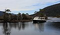 Our ride down Lake St. Clair
 Lake St Clair NP Tas
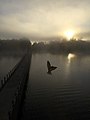 Swallow in the mist of dawn, Pumphouse Point, Lake St Clair
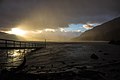 Echo Point, Lake St Clair at dawn


See also
- List of reservoirs and dams in Australia § Tasmania
- List of lakes of Australia § Tasmania
- Overland Track
References
- "Lake Saint Clair". Britannica. Retrieved 13 October 2021.
- "Map of Lake Saint Clair, TAS". Bonzle Digital Atlas of Australia. n.d. Retrieved 1 June 2018.
- "Placenames Tasmania – Lake St Clair". Placenames Tasmania. Select “Search”, enter "39197M", click “Search”, select row, map is displayed, click “Details”. Retrieved 4 August 2020.
- Manwaring, Lynda. "Lake St. Clair, TAS". Aussie Towns.
- Byers, Michael Charles (1996). Tourism and bushwalking in the Cradle Mountain-Lake St Clair National Park: Context, characteristics and impacts (PDF) (Masters). The University of Tasmania.
- "History of Pumphouse Point - Pumphousepoint.com.au". Pumphouse Point | Lake St Clair Tasmania.
- "LIST Locality and Postcode Areas". theLIST ©State of Tasmania [CC BY 3.0 AU]. 18 July 2016. Retrieved 15 September 2018.
- Google (4 August 2020). "Lake St Clair, Tasmania" (Map). Google Maps. Google. Retrieved 4 August 2020.
- "Tasmanian Road Route Codes" (PDF). Department of Primary Industries, Parks, Water & Environment. May 2017. Archived from the original (PDF) on 1 August 2017. Retrieved 4 August 2020.
- "Walch's Tasmanian Guidebook". 1871.
- "Cynthia Bay, Lake St Clair: Site Plan 2004". Parks and Wildlife Service Tasmania.
- "Tasmanian Environmental Law Tangles". Law Report. Radio National (Australian Broadcasting Corporation). 15 June 2004. Retrieved 15 August 2013.
- "Developer claims time is right for Pumphouse Point project". ABC News. Australia. 4 February 2008. Retrieved 15 August 2013.
- Hope, Emma (6 July 2017). "Work starts on Pumphouse Point wilderness retreat development". The Mercury. Hobart, Tasmania.
External links
- "Lake St Clair". Parks & Wildlife Service. Government of Tasmania. 29 July 2016.
- "Tasmanian Wilderness World Heritage Area Management Plan 2016" (PDF). Department of Primary Industries, Parks,Water and Environment. Hobart: Government of Tasmania. 2016. ISBN 978-0-7246-6806-9.
- Lake St Clair Fishing Information & Map
Lakes and other bodies of water in Tasmania, Australia | |
|---|---|
| Coastal lagoons and lakes | |
| Freshwater | |
| Glacial | |
| Salt |
|
| Man-made reservoirs | |
| Authority control: National libraries |
|---|
На других языках
[de] Lake St. Clair (Tasmanien)
Der Lake St. Clair ist ein See im Westen des australischen Bundesstaates Tasmanien.- [en] Lake St Clair (Tasmania)
[es] St Clair (lago)
El lago Saint Clair o St Clair (en inglés: Lake St Clair) es un lago australiano de agua dulce situado en las Tierras Altas Centrales de Tasmania. Forma parte del Parque nacional Cradle Mountain-Lake St Clair. El lago tiene una profundidad máxima de 215 m lo que le hace el lago más profundo de Australia y también el más profundo del mundo creado por la acción de los glaciares.[fr] Lac Saint Clair (Tasmanie)
Le Lac Saint Clair est un des nombreux lacs situés dans les Massifs Centraux de Tasmanie, en Australie. Il est situé dans le parc national de Cradle Mountain-Lake St Clair.[it] Lago St Clair
Il lago St Clair (Lake St Clair in inglese e leeawulenna in lingua aborigena) è un lago d'acqua dolce di origine naturale situato nell'area degli altopiani centrali della Tasmania in Australia. Il lago costituisce la sezione meridionale del Parco nazionale del monte Cradle-lago St Clair. Copre una superficie di circa 45 km quadrati e presenta una profondità massima di 160 m, cosa che lo rende il lago più profondo dell'Australia.[1][ru] Сент-Клэр (озеро, Тасмания)
Озеро Сент-Клэр (англ. Lake St Clair) — озеро, расположенное на Центральной возвышенности[en] (англ. Central Highlands) острова Тасмания (Австралия). Максимальная глубина озера — 174 м[2]; тем самым, оно является самым глубоким озером Австралии[1]. Площадь озера — 30 км²[1], высота водной поверхности — 737 м над уровнем моря[3][4][2].Другой контент может иметь иную лицензию. Перед использованием материалов сайта WikiSort.org внимательно изучите правила лицензирования конкретных элементов наполнения сайта.
WikiSort.org - проект по пересортировке и дополнению контента Википедии