geo.wikisort.org - Reservoir
Kolkewadi Dam or Kolkiwadi Dam is a dam located in the Konkani region, Ratnagiri district of Maharashtra, India. It is located in Kolkiwadi, about 3.0 km (1.9 mi) near the village of Alore, near Chiplun.
| Kolkewadi Dam | |
|---|---|
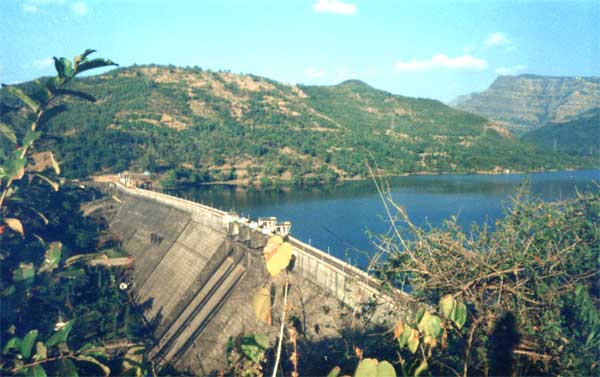 Kolkewadi Dam from a distance | |
 Location of Kolkewadi Dam in Maharashtra | |
| Official name | Kolkewadi Dam D05103 |
| Location | Maharashtra, India |
| Coordinates | 17.4730°N 73.6438°E |
| Opening date | 1975[1] |
| Dam and spillways | |
| Impounds | Vashishti River |
| Height | 63.3 metres (207.7 ft) |
| Length | 497 metres (1,631 ft) |
Description

The dam is part of the Koyna Hydroelectric Project. It contributes in the 3rd stage of power generation of the Koyna Hydroelectric Project. The electricity is generated in the underground power station located at the base of the dam. The total installed generating capacity of the 3rd stage of the project is 320 MW. The project is run by the Maharashtra State Electricity Board, also known as the MSEB. The area behind the dam is one of the most sparsely populated areas in the state.
The spillway of the dam is located at the center. It has 3 radial gates.
See also
- Konkan division
- Vashishti River
- Western Ghats
References
- "Water Resources Information System of India". Kolkewadi D05103. Archived from the original on 22 February 2014. Retrieved 13 March 2013.
External links
- "Koyna hydro‑electric project". Retrieved 13 March 2013.
Другой контент может иметь иную лицензию. Перед использованием материалов сайта WikiSort.org внимательно изучите правила лицензирования конкретных элементов наполнения сайта.
WikiSort.org - проект по пересортировке и дополнению контента Википедии