geo.wikisort.org - Reservoir
The Burdekin Dam, officially the Burdekin Falls Dam, is a concrete gravity dam with an uncontrolled spillway across the Burdekin River, located south west of Ayr, and Home Hill in North Queensland, Australia. Built for the purpose of irrigation, the reservoir, called Lake Dalrymple. Burdekin Dam is managed by SunWater. Water from the reservoir is also used to replenish downstream aquifers.[2]
| Burdekin Dam | |
|---|---|
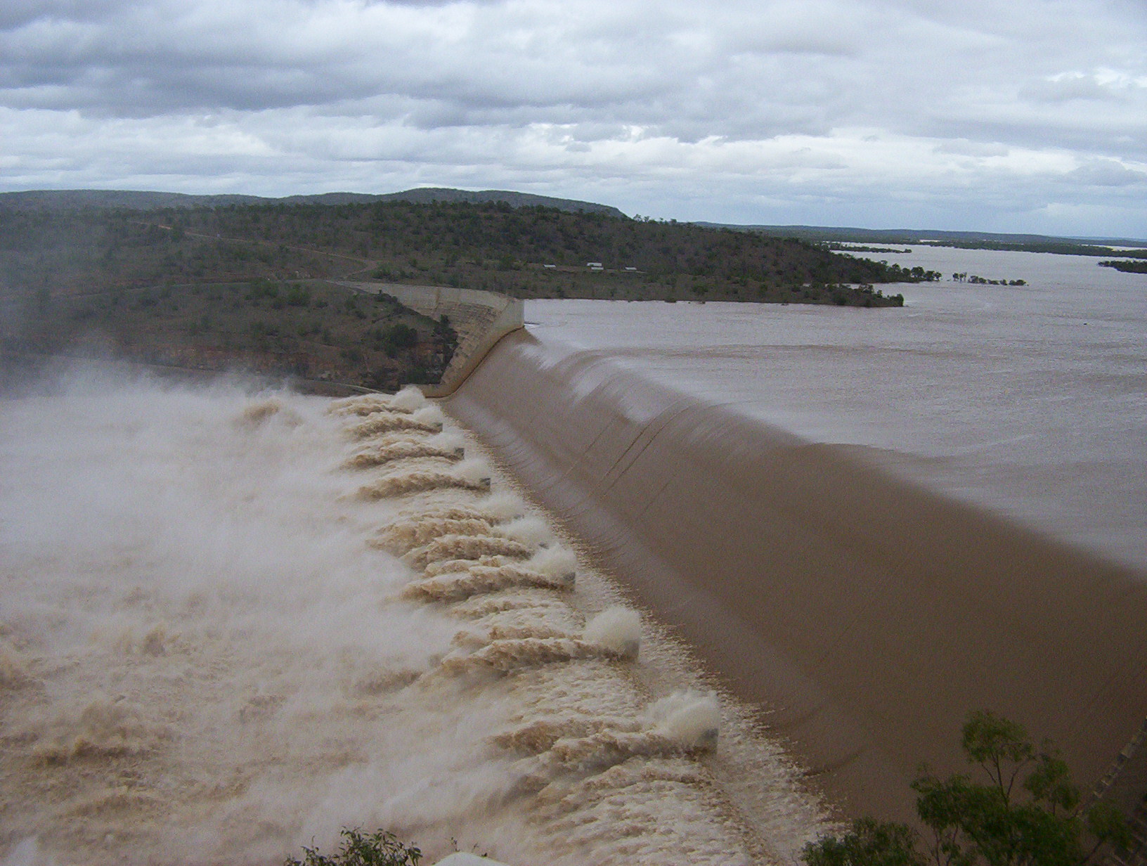
 Burdekin Dam, 2009 | |
 Location of the Burdekin Dam wall in Queensland | |
| Official name | Burdekin Falls Dam |
| Country | Australia |
| Location | North Queensland |
| Coordinates | 20°38′33″S 147°08′27″E |
| Purpose | Irrigation |
| Opening date | 1987 |
| Owner(s) | SunWater |
| Dam and spillways | |
| Type of dam | Gravity dam |
| Impounds | Burdekin River |
| Height | 55 m (180 ft) |
| Length | 876 m (2,874 ft) |
| Dam volume | 1,860,000×103 m3 (66,000×106 cu ft) |
| Spillways | 1 |
| Spillway type | Uncontrolled |
| Spillway capacity | 64,600 m3/s (2,280,000 cu ft/s) |
| Reservoir | |
| Creates | Lake Dalrymple |
| Total capacity | 1,860,000 ML (410×109 imp gal; 490×109 US gal)[1] |
| Catchment area | 114,220 km2 (44,100 sq mi) |
| Surface area | 22,400 ha (55,000 acres) |
| Maximum water depth | 40 m (130 ft) |
| Normal elevation | 154 m (505 ft) |
Location and features
The dam wall is 876 metres (2,874 ft) long and has a 504-metre (1,654 ft) spillway, and a drop of 37 metres (121 ft). The reservoir holds 1,860,000 megalitres (410×109 imp gal; 490×109 US gal) at full capacity. The design allows for future storage capacity increases and potential for hydro-electricity generation.[2] Plans are in place to increase the safety of this dam in an extreme rainfall event by increasing the spillway capacity. This project is scheduled for completion over the next[when?] 5 to 20 years.[3]
The catchment area for the dam extends north to the Seaview Range west of Ingham, south to the Drummond Range near Alpha through the Suttor and Belyando Rivers, southeast to the coastal ranges west of Mackay, and west beyond Charters Towers to the Lolworth, Montgomery and Stopem Blockem Ranges through the Clarke River.
History
Construction of the dam began in 1984. It was completed by Leighton Contractors in 1987 and is the largest dam in the state, with a capacity four times that of Sydney Harbour.[4] Burdekin Dam filled after the wet season in 1988.[2]
Irrigation
The Burdekin River Irrigation Area was granted approval in 1980. It is Queensland's largest land and water conservation scheme.[2] In 2007, the scheme was supplying 103,000 ha of land located about 200 kilometres (120 mi) inland from Townsville with water to grow a range of crops including sugar cane, cotton and rice.[2]
Proposed hydroelectricity
Stanwell Corporation has begun a feasibility study into a proposed 37 megawatts (50,000 hp) hydroelectric power station below the Burdekin Dam wall. It is proposed it would be capable of producing 125,000 megawatt-hours (450,000 GJ) annually, enough to power more than 9,500 homes each year.[5][6]
Boating
There are no boating restrictions, with a single boat ramp located near the dam wall. Water in the dam is often muddied with unsettled sediment long after the rains have washed it into the lake. This not only makes angling difficult but also means boating can be hazardous at high speeds due to the presence of submerged rocks.[7]
Fauna and flora
The dam has been stocked with sleepy cod, sooty grunter and barramundi. Numerous other species are present naturally, including forktail catfish, spangled perch, eel-tailed catfish, long tom, golden perch and archer fish.[7] A Stocked Impoundment Permit is required to fish in the dam. Red-claw crayfish and freshwater crocodiles although not native to this river may also found in the dam. These were probably released by people who caught them from rivers of the Gulf of Carpentaria..[7] Saltwater crocodiles are commonly known to take cattle from the reaches of both Burdekin and Suttor river sections of Lake Dalrymple reaches of the dam.[8]
Awards
In 2009 as part of the Q150 celebrations, the Burdekin Falls Dam was announced as one of the Q150 Icons of Queensland for its role as a "structure and engineering feat".[9]
See also
References
- "Sunwater Current Water Storage Information". Archived from the original on 28 May 2010. Retrieved 18 February 2008.
- Pigram, John J. (2007). Australia's Water Resources: From use to management. Collingwood, Victoria: CSIRO Publishing. pp. 50–51. ISBN 978-0-643-09442-0.
- Current Projects Archived 13 February 2008 at the Wayback Machine
- Leighton Holdings History Archived 11 December 2007 at the Wayback Machine
- "Burdekin Hydro". Stanwell Corp. Retrieved 4 February 2012.[permanent dead link]
- "Queensland's Snowy 2.0 and Burdekin Hydro Plans Power Ahead". TheUrbanDeveloper.com. 25 October 2017. Archived from the original on 27 October 2017. Retrieved 2 November 2017.
- Harrison, Rod; Ernie James; Chris Sully; Bill Classon; Joy Eckermann (2008). Queensland Dams. Bayswater, Victoria: Australian Fishing Network. pp. 92–93. ISBN 978-1-86513-134-4.
- Burdekin Falls Dam visitor information (PDF). Sunwater (Queensland). 2013. p. 2. Archived from the original (PDF) on 11 March 2017. Retrieved 26 January 2017.
- Bligh, Anna (10 June 2009). "PREMIER UNVEILS QUEENSLAND'S 150 ICONS". Queensland Government. Archived from the original on 24 May 2017. Retrieved 24 May 2017.
External links
- Pictures- National Library of Australia
- More historical Photos from the NQ Dry Tropics
- Burdekin Dam Fishing Information & Map
Water supply in Queensland, Australia | |||||||||||||||||||||||
|---|---|---|---|---|---|---|---|---|---|---|---|---|---|---|---|---|---|---|---|---|---|---|---|
| |||||||||||||||||||||||
| |||||||||||||||||||||||
| |||||||||||||||||||||||
Другой контент может иметь иную лицензию. Перед использованием материалов сайта WikiSort.org внимательно изучите правила лицензирования конкретных элементов наполнения сайта.
WikiSort.org - проект по пересортировке и дополнению контента Википедии