geo.wikisort.org - Mountains
Pukematekeo is a hill in the Waitākere Ranges of the Auckland Region of New Zealand's North Island. It is located west of Henderson, and is the northernmost hill in the Waitākere Ranges Regional Park.
| Pukematekeo | |
|---|---|
 Pukematekeo seen from Glen Eden | |
| Highest point | |
| Elevation | 336 m (1,102 ft) |
| Coordinates | 36.88344°S 174.53835°E |
| Geography | |

| |
| Location | North Island, New Zealand |
| Parent range | Waitākere Ranges |
| Geology | |
| Age of rock | Miocene |
Description
The hill is a 336-metre peak in the Waitākere Ranges, and is the northern-most hill in the ranges. The hill is the source for two river systems: the Kumeū River, which flows north to meet the Kaipara River and eventually flows into the Kaipara Harbour,[1] and the Cassel Stream, which flows eastwards to join the Swanson Stream, which flows into Te Wai-o-Pareira / Henderson Creek and the Waitematā Harbour.[2][3]
The hill is accessible by Scenic Drive, and is a starting point for the Pukematekeo Track, a walking track linking the peak and the Waitākere Golf Club to the west.
Geology
Pukematekeo is the remnant of one of the eastern vents of the Waitākere Volcano, a Miocene era volcanic crater complex which was uplifted from the seafloor between 3 and 5 million years ago.[4] Pukematekeo consists of tilted andesite flows and volcanic litharenites.[5] The 100 metre thick sequence is composed of at least 11 thin andesite flows, interspersed with pyroclastic deposits and lapilli tuffs.[5]
History
Pukematekeo is within the traditional rohe of the Te Kawerau ā Maki iwi, and holds significant cultural and spiritual significance.[3] The name Pukematekeo in Māori is a geographical description, referring to how it is the final hill of the Waitākere Ranges.[6] Pukematakeo was the site of a Te Kawerau ā Maki pā, one of only a few known in the inland Waitākere Ranges.[7]
Pukematekeo was the location of Ebenezer Gibbons' kauri sawmill tramline, connecting the base of the hill to Swanson railway station. The sawmill and tramline operated between 1885 and 1888.[8] The path of the tramline was later repurposed as Tram Valley Road in Swanson.[9] Pioneering farmer Thomas George established a sheep farm with his family settled near Pukematekeo in the 1860s, however by the 1920s most of the pasture had been reforested by native bush.[10]
The land around Pukematekeo was purchased from settlers by the Auckland City Council in 1926 through the Public Works Act, in order to create a scenic kauri forest reserve, which later formed a section of the greater Waitākere Ranges Regional Park.[11][12][13] In 1928, a significant scrub fire damaged native forest on the eastern slopes of Pukematekeo.[14]
On 10 June 1939, road access to Pukematekeo was first made possible, when an extension of Scenic Drive was opened between Waiatarua and Swanson.[15]
Gallery
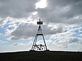 Trig station at the summit of Pukematekeo
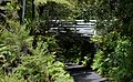 Isolated bridge and native flora at Pukematekeo
 View of Auckland from Pukematekeo


References
- "Kumeū River". New Zealand Gazetteer. Land Information New Zealand. Retrieved 9 June 2022.
- "Cassel Stream". New Zealand Gazetteer. Land Information New Zealand. Retrieved 9 June 2022.
- Te Kawerau ā Maki; The Trustees of Te Kawerau Iwi Settlement Trust; The Crown (12 December 2013). "Deed of Settlement Schedule: Documents" (PDF). Retrieved 26 April 2022.
- Hayward, Bruce (2009). "Land, Sea and Sky". In Macdonald, Finlay; Kerr, Ruth (eds.). West: The History of Waitakere. Random House. pp. 10, 13–14. ISBN 9781869790080.
- Hayward, B. W. (1977). "Miocene volcanic centres of the Waitakere Ranges, North Auckland, New Zealand". Journal of the Royal Society of New Zealand. 7 (2): 123–141. doi:10.1080/03036758.1977.10427155.
- "Pukematekeo". New Zealand Gazetteer. Land Information New Zealand. Retrieved 9 June 2022.
- Diamond, John T.; Hayward, Bruce W. (1979). The Māori history and legends of the Waitākere Ranges. The Lodestar Press. p. 12. ISBN 9781877431210.
- Russell Foster and Associates (February 2018). "Proposed Subdivision, 7 Christian Road, Swanson, Archaeological Assessment" (PDF). Auckland Council. Retrieved 9 June 2022.
- Brown, Jim (1992). "Timber Working at Waitakere". In Northcote-Bade, James (ed.). West Auckland Remembers, Volume 2. West Auckland Historical Society. p. 66. ISBN 0-473-01587-0.
- Luxton, David (2009). "Struggle Country". In Macdonald, Finlay; Kerr, Ruth (eds.). West: The History of Waitakere. Random House. pp. 73–74. ISBN 9781869790080.
- "Land for the City". The New Zealand Herald. Vol. LXIII, no. 19375. 9 July 1926. p. 12. Retrieved 9 June 2022 – via Papers Past.
- "Park in Waitakeres". The New Zealand Herald. Vol. LXIII, no. 19487. 17 November 1926. p. 14. Retrieved 9 June 2022 – via Papers Past.
- "Waitakere Ranges". The New Zealand Herald. Vol. LXIII, no. 19393. 30 July 1926. p. 8. Retrieved 9 June 2022 – via Papers Past.
- "Kauri Bush Saved". The New Zealand Herald. Vol. LXV, no. 19849. 20 January 1928. p. 10. Retrieved 9 June 2022 – via Papers Past.
- "Auckland's New Scenic Drive to Be Opened To-day". The New Zealand Herald. Vol. LXXVI, no. 23369. 10 June 1939. p. 10. Retrieved 9 June 2022 – via Papers Past.
Другой контент может иметь иную лицензию. Перед использованием материалов сайта WikiSort.org внимательно изучите правила лицензирования конкретных элементов наполнения сайта.
WikiSort.org - проект по пересортировке и дополнению контента Википедии