geo.wikisort.org - River
Kitekite Falls (also called Kitakita Falls[1]) is a scenic 3-tiered waterfall near Auckland, New Zealand. The falls drop a total of 40 metres (130 ft).[2] From the lookout on Kitekite track the falls appear even higher because there is white water running over rocks into a small pool from the upper swimming hole, then falling down into a large pool, then falling to a small pool before beginning an almost vertical descent in the final 3-tiers, making the total height closer to 80 metres (260 ft).[3] They are located on the Glen Esk stream near Piha Beach.

History
The area close to Kitekite Falls was milled for kauri from 1910, when logs were flushed downstream to the Piha Mill. The mill operated adjacent to the waterfall (downstream at the site of Stedfast Park) until 1921.[4] All the mature trees in the area were cut down. At the top of the falls, it is clear to see the notches in the rocks (rectangular cutouts for large pieces of wood to rest in). This was the location of the Glen Esk dam. The first attempt to drive logs down the falls resulted in their destruction on the rocks below and the dam was thereafter only used to flush the logs waiting in the stream below down to the mill. The remains of the heavy beams used can still be found in the stream today although they tend to move from time to time. In 2007 a beam fell, broke and half of it wedged itself into rocks at the base of the three tiered falls.[5]
Kitekite Falls walk
The walk reopened Boxing Day 2018 with more covered walkways to protect the kauri. It had been closed to the public due to kauri dieback and under rāhui from Te Kawerau ā Maki in conjunction with the Waitākere Ranges Local Board and Auckland Council. Te Kawerau ā Maki have released a clarification on the area covered by the Waitakere rāhui to make it clear to residents and visitors that it only covers the forest, but that within the forest all tracks are closed by the rāhui. From the carpark at the end of Glenesk Road, directions are clearly signposted.
A loop track, used by around 30,000 people a year (2005),[6] follows the Glen Esk Stream with minor undulations (on the south side) up to a lookout with a large Macrocarpa bench seat, made by offenders doing community work (2005). The track then descends down wooden steps to the base of the falls (40 minutes from the carpark). The track then crosses the stream next to the lower swimming hole and returns down the north side. Walkers can also climb a reasonably steep track (the Connect Track), which begins about 100m from the base of the falls on the northern side of the stream. It takes about 15 minutes to get to the top of the falls.[7] There is a swimming hole at the top.
Local flora and fauna

It has taken many decades for the young kauri (Agathis australis), known as 'rickers' to regenerate and finally, begin to emerge through the forest canopy again. Many sharp pointed, cone shaped, rickers can be seen from the Kitekite loop track near the falls. At about 100 years old, kauri begin to develop a spreading crown. It is now approaching 100 years since milling stopped. The crowns generally continue to expand for a further 500 years.[8]
The walk to the falls progresses through a patch of nikau palms where the call of the Tui (bird) is frequently heard from above. Other native plants include silver tree ferns, puriri trees whose red berries attract kereru (native pigeon), and the rangioroa plant (bushman's friend due to the soft underside of its broad leaf).[9] The falls have been identified as a site of a rare moss Fissidens rigidulus var. pseudostrictus.[10]
New Zealand longfin eel, (Anguilla dieffenbachii) hide among the rocks around the base of the falls.
Place names
The name 'Kitekite' is likely a misspelling. While sometimes listed as Kitakita, Te Kawerau ā Maki kaumātua Rewi Spraggon believes the traditional name was Ketekete, referring to a clicking sound made before an ambush.[11]
'Glen Esk' stream was named by William Stockwell. He emigrated to New Zealand in 1876 and bought land above Kitekite Falls soon after his arrival. He named the area 'Glen Esk' because it reminded him of his homeland in Scotland.[12] 'Glen', from Gaelic, an Indo-European language spoken in Scotland (UK) and Ireland means 'valley'. 'Esk' is of Celtic origin and means 'water'.
Canyoning
The falls are used for canyoning by an Auckland Regional Parks licensed operator.[13] The issuing of the licence was a 'hot issue' at the 2002 AGM of the Piha Ratepayers and Residents Association where residents voiced concern over the environmental impact to the Kitekite Falls. However, ARC recreation coordinator Lee Whiley said there were no concerns.[14] This recreational activity continues to this day under close monitoring by council. Climbing on the falls (going off track) is strictly prohibited and can only be done with a permit or licensed guide. Restrictions are in place to protect the rare moss growing in the wet areas of the waterfall.
 View from the Kitekite track lookout. The track then takes a steep descent to the base of the falls.
 This young Kauri is around 100 years old. Its crown is beginning to spread above the forest canopy.
 The Kitekite track descending to the base of the falls after the lookout. A beautiful Nikau Palm.
 The upper swimming hole is just out of view above this small white water fall.
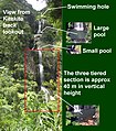 The 3-tiered falls descend 40m. Above them, waterfalls cascade over rocks (set back in pic)down about 40 m.
 From this upper swimming hole, water cascades down 40 m before a final descent of 40 m over the three tiers.


See also
- Waterfalls of New Zealand
References
- "Place name detail: Kitakita Falls". New Zealand Gazetteer. New Zealand Geographic Board. Retrieved 2010-04-20.
- http://www.world-of-waterfalls.com/new-zealand-kitekite-falls.html New Zealand waterfalls by Johnny T. Cheng Page 44
- Estimation only (see photo)
- Cameron, Ewen; Hayward, Bruce; Murdoch, Graeme (2008). A Field Guide to Auckland: Exploring the Region's Natural and Historical Heritage (Revised ed.). Random House New Zealand. p. 173. ISBN 978-1-86962-1513.
- Verbal account given by local canyoning expert 2008
- Dept of corrections - Community Works , Issue 3, June 2005
- Day Walks of Greater Auckland (2003) by Marios Gavalas and Peter Janssen, Reed Publishing (NZ) Ltd. Page 63
- Kauri - New Zealand's Ancient Forest (2005) by Doreen Franke, Page 3
- Article by Margaret Turton May 25, 2007
- Waitakere Ranges Protection Society Inc. News Issue 124 Nov. 2004
- "Cheeky long weekend: Piha". The New Zealand Herald. 3 November 2013. Retrieved 29 September 2022.
- "Piha History continued". Archived from the original on 2010-05-23. Retrieved 2014-08-25. Retrieved 1 February 2008
- "About AWOL". Archived from the original on 2008-01-17. Retrieved 2014-08-25. Retrieved 22 January 2008
- http://www.piha.co.nz/hotissuesarchive.htm#canyoning Archived 2008-10-14 at the Wayback Machine from an article by Sandra Coney from the 'Hot Issues Archive' containing links to 'Hot Issues' around Piha. Retrieved 22 January 2008
External links
- Piha at the Auckland Council
- KiteKite Falls at World of Waterfalls
На других языках
[de] Kitekite Falls
Die Kitekite Falls (auch Kitakita Falls)[1] sind ein dreistufiger Wasserfall östlich von Piha in der Region Auckland auf der Nordinsel Neuseelands. Die Fallhöhe beträgt insgesamt 40 Meter.[2] Vom Aussichtspunkt am Kitekite Track erscheint der Wasserfall höher, da das Wildwasser zuerst vom oberen Becken über die Felsen in einen kleinen Pool fällt, von dort aus fällt es in einen großen Pool, dann in einen weiteren. Erst dann beginnt der eigentliche, nahezu senkrechte dreistufige Wasserfall, so dass die Gesamthöhe des Abstieges nahezu 80 m beträgt. Die Fälle sind Teil des Glen Esk Stream und liegen in der Nähe des Piha-Strandes.- [en] Kitekite Falls
Другой контент может иметь иную лицензию. Перед использованием материалов сайта WikiSort.org внимательно изучите правила лицензирования конкретных элементов наполнения сайта.
WikiSort.org - проект по пересортировке и дополнению контента Википедии