geo.wikisort.org - Mountains
Monte San Petrone is a mountain in the department of Haute-Corse on the island of Corsica, France. It is the highest mountain in the Monte San Petrone massif, the southernmost of the schist massifs of the northeast of the island.
| Monte San Petrone | |
|---|---|
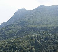
 View of the mountain from Lano. On the right, the village of San-Lorenzo | |
| Highest point | |
| Elevation | 1,767 m (5,797 ft) |
| Prominence | 1,208 m (3,963 ft) |
| Isolation | 18.55 km (11.53 mi) |
| Coordinates | 42.39625°N 9.32681°E |
| Geography | |
 Monte San Petrone | |
| Country | France |
| Department | Haute-Corse |
Location
The Monte San Petrone is the highest peak in the Castagniccia region, named after the abundant sweet chestnut trees, in the northeast of Corsica. It is bounded by the Golo valley to the north, the Tyrhanian Sea to the east, the Tavignano valley to the south and the central valley of Corse from Corte to Ponte Leccia in the east.[1] There are three ridges in the district running roughly north-south: the Mont Piano Maggiore ridge is in the west, the Monte San Pedrone ridge is in the center and is the main ridge of the region, and the eastern ridge includes Monte Negrine and Monte Castello d'Osani.[1]
The peak marks the meeting point of the boundaries of the cantons of Saliceto to the northwest, Nocario to the northeast, Campana to the southeast and San-Lorenzo to the southwest. The Statuette of San Petru is on the eastern slope of the mountain. The village of Saliceto is to the west and Nocario is to the east. The Fium'Alto river originates on the south of the mountain.[2]
Physical
Monte San Petrone has an elevation of 1,767 metres (5,797 ft), clean prominence of 1,208 metres (3,963 ft) and isolation of 18.55 kilometres (11.53 mi). Its nearest higher neighbor is Pinerole at 1,951 metres (6,401 ft), to the west northwest.[3][lower-alpha 1] Monte Cinto, the highest mountain on the island, is 19.5 miles (31.4 km) west.[4]
Hiking
Hikers can access Monte San Petrone in the spring, summer and autumn. It may have snow cover in the winter. The trail from Col de Prato on the D71 road mainly runs through beach and pine woods, which provide shade from the summer heat.[1] The trail is 6 kilometres (3.7 mi) long and rises 800 metres (2,600 ft). It may take a walker in good condition three hours to complete.[5]
Gallery
 Monte San Petrone seen from Ampugnani
 Panorama of the summit on the west side: the pieve du Vallerustie
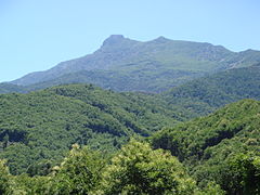 The Ampugnani valley and the summit of San Petrone
 San Petrone seen from Carticasi
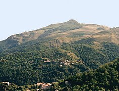 San Petrone and its gentle slopes on the Vallerustie side
 Crocicchia north of San Petrone.
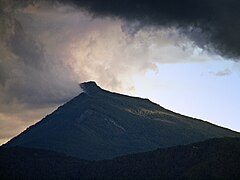 View of San Petrone from Bigorno Pass


Notes
- PeakVisor says that the nearest higher neighbour is Pinzi a i Giuelli, 11.6 miles (18.7 km) to the west.[4]
Citations
Sources
- "Ascension du san petrone au coeur de la castagniccia", Visit Corsica, Collectivité Territoriale de Corse: Agence du Tourisme, retrieved 2021-12-04
- "Monte San Petrone", PeakVisor, retrieved 2021-12-04
- "Monte San Petrone", SummitPost, retrieved 2021-12-03
- "Node: Monte San Petrone (26863958)", OpenStreetMap, retrieved 2021-12-03
- Petter Bjørstad, "Monte San Petrone, France", Peakbagger, retrieved 2021-12-03
Landforms of the Haute-Corse department | ||
|---|---|---|
| Massifs |  | |
| Peaks | ||
| Passes |
| |
| ||
На других языках
[de] Monte San Petrone
Der Monte San Petrone ist ein 1767 Meter hoher Berg im Norden Korsikas und der höchste Berg der Castagniccia. Der Berg befindet sich in einem Nord-Süd verlaufenden Bergkamm. Die Westflanke ist sanft geneigt und mit Wäldern bedeckt. Die Ostflanke ist steil und felsig. Der Berg ist wegen seiner schönen Aussicht auf Korsikas Ostküste, Cap Corse und das Monte Cinto-Massiv ein beliebtes Wanderziel. Am Gipfel befindet sich ein schmiedeeisernes Kreuz mit einer eingemauerten Skulptur des San Petru.- [en] Monte San Petrone
[fr] Monte San Petrone
Le Monte San Petrone est une montagne située dans le département de la Haute-Corse.[it] Monte San Petrone
Il Monte San Petrone (o Monte S. Pietro; in corso: Monte San Pedrone) è un monte e un massiccio scistoso della Corsica nordorientale.[1]Другой контент может иметь иную лицензию. Перед использованием материалов сайта WikiSort.org внимательно изучите правила лицензирования конкретных элементов наполнения сайта.
WikiSort.org - проект по пересортировке и дополнению контента Википедии