geo.wikisort.org - Mountains
The[lower-alpha 1][1] Paglia Orba (pronounced /ˌpa.ʎa ˈɔːr.ba/) is a mountain peak in the Monte Cinto massif in Corsica. It rises to an altitude of 2,525 metres (8,284 ft), between the valleys of the Golo (in the Niolo) and the Cavicchia (in the Filosorma). Relatively isolated, this peak, notable for its characteristic tooth-shaped silhouette, dominates the Fango Valley and the west coast of the island.
| Paglia Orba | |
|---|---|
 Summit, with Capu Tafunatu on its right (aerial photo) | |
| Highest point | |
| Elevation | 2,525 m (8,284 ft) |
| Prominence | 530 m (1,740 ft) |
| Isolation | 4.6 km (2.9 mi) |
| Coordinates | 42°20′33″N 8°52′43″E |
| Geography | |
 Paglia Orba | |
| Country | France |
| Department | Haute-Corse |
| Parent range | Monte Cinto massif |
| Geology | |
| Age of rock | Permian, Miocene |
Straddling the municipalities of Albertacce and Manso, Paglia Orba is the second highest peak of the central chain and the Filosorma, behind Punta Minuta at 2,556 metres (8,386 ft).
Geography
With an altitude of 2,525 metres (8,284 ft), the Paglia Orba is located in the municipalities of Albertacce and Manso. It is nearly 200 metres (660 ft) lower than Monte Cinto. The Golo, the longest river in Corsica, rises at its feet.
On its slopes at an altitude of 1,384 metres (4,541 ft) the Ruisseau Orba rises in the communal forest of Albertacce, which is a monoculture of laricio pines.
Geology

Unlike the other summits of the Cinto massif, which are formed mainly of volcanic rocks, the Paglia Orba is made up of sandstone and conglomerates[2] (puddingstone) with some boulders exceeding 1 cubic metre (35 cu ft) in size.
These sedimentary rocks accumulated during the Permian-Triassic within a vast zone of volcanic collapse (a lake occupying a caldera), before being raised to altitude then largely destroyed by erosion during the tertiary era.[3][4] Only a few rare vestiges of this sedimentary filling remain today, including the Paglia Orba preserved on the southwestern edge of this caldera.
Access
The normal access road to the summit is somewhere between hiking and mountaineering. From the Ciottulu a i Mori refuge, a path leads to the Col des Maures (Moorish Pass) and then up a very steep corridor on the western slope of the Paglia Orba. The route marked by cairns then overlooks a cliff to reach a first summit, separated from the true summit by a ravine called "combe des Chèvres". Other steep routes exist on the south side (vertical fractures or chimneys) but require experience in climbing.[5]
Experienced hikers and mountaineers can also complete the tour of the Paglia Orba[6] by crossing the "Geologists' Breach", named in memory of a geologist who died there,[7][8]) and the "Sphinx Breach", near a characteristic looking rock block.
Climbing
The dizzying faces and ridges of this "queen of the Corsican mountains" offer climbers a multitude of routes rated “AD” to “ED”.[9]
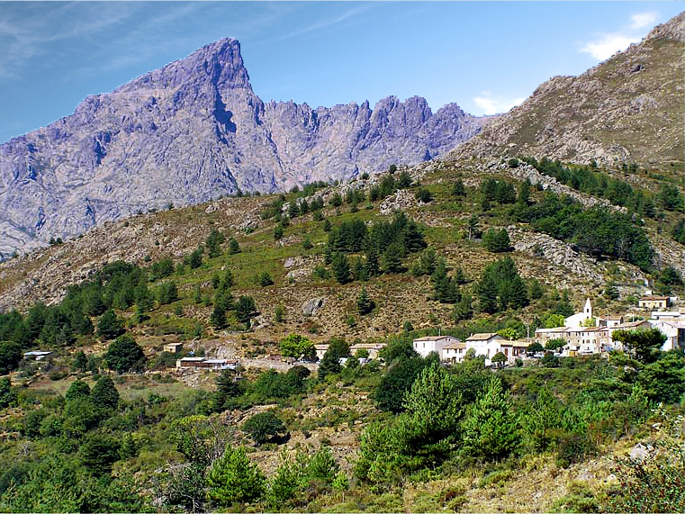
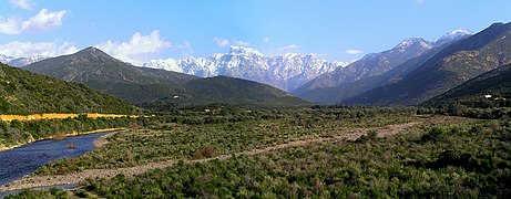 The Paglia Orba seen from the Pont des 5 Arcades (D81) in Galéria, above the Fango valley.
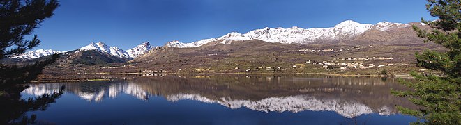 La Paglia Orba (left) seen from the Lac de Calacuccia. In the middle, Monte Cintu.


Notes
- French-language books often treat the name as feminine, but in Corsican it is masculine.
- Chiorboli 2020.
- BRGM 1996.
- Gauthier 2015, p. 62.
- Bouchra Zarki‐Jakni et al. 2004.
- Fabrikant 1982, p. 196-198.
- Fabrikant 1982, p. 208.
- Fabrikant 1982, p. 190.
- Climber killed.
- Fabrikant 1982, p. 194-195.
Sources
- Bouchra Zarki‐Jakni; Peter van der Beek; Gérard Poupeau; Marc Sosson; Erika Labrin; Philippe Rossi; Jean Ferrandini (February 2004), "Cenozoic denudation of Corsica in response to Ligurian and Tyrrhenian extension: Results from apatite fission track thermochronology", Tectonics, 23 (1), doi:10.1029/2003TC001535, ISSN 0278-7407, retrieved 3 March 2021
- BRGM (1996), "Notice de la carte géologique de la France à 1/50000 feuille Galeria-Osani" (PDF), Infoterre, retrieved 2 March 2021*Chiorboli, Jean (27 March 2020), "Paglia Orba : sommets corses emblématiques", Corse-Matin « Settimana » (in French), ISSN 2429-4764
- "Climber killed", Belfast Telegraph: 7, 25 July 1961, ISSN 0307-5664
- Fabrikant, Michel (1982), Guide des montagnes corses : Randonnées pédestres et escalades, Cartes et guides de Corse (in French), Grenoble: Didier Richard, p. 408, ISBN 978-2-7038-0018-7
- Gauthier, Alain (2015), Corse, l'Élysée du Géologue, Albiana, p. 232, ISBN 978-2-8241-0632-8
Landforms of the Haute-Corse department | ||
|---|---|---|
| Massifs |  | |
| Peaks | ||
| Passes |
| |
| ||
На других языках
[de] Paglia Orba
Die Paglia Orba ist ein 2525 m hoher Berg auf Korsika. Durch ihre relativ isolierte Lage dominiert sie die Westküste der Insel. Sie wird als „Königin der korsischen Berge“, aufgrund der charakteristischen Silhouette manchmal auch als das „Matterhorn Korsikas“ bezeichnet. Die Paglia Orba liegt etwa 7 km südwestlich des Monte Cinto.- [en] Paglia Orba
[fr] Paglia Orba
La[Note 1],[2] Paglia Orba (prononcé [ˌpa.ʎa ˈɔːr.ba]) est un sommet montagneux du massif du Cinto en Corse. Elle s'élève à 2 525 mètres d'altitude, à la jonction amont des vallées du Golo (dans le Niolo) et de la Cavicchia (dans le Filosorma). Relativement isolé, ce sommet remarquable par sa silhouette caractéristique en forme de dent domine la vallée du Fango et la côte occidentale de l'île.[it] Paglia Orba
Il monte Paglia Orba è uno dei monti più famosi della Corsica e la terza vetta dell'isola per altezza[1]: è un massiccio isolato, e domina la costa ovest dell'isola; viene soprannominato il « Cervino corso » o anche la « Regina delle montagne corse ».Другой контент может иметь иную лицензию. Перед использованием материалов сайта WikiSort.org внимательно изучите правила лицензирования конкретных элементов наполнения сайта.
WikiSort.org - проект по пересортировке и дополнению контента Википедии