geo.wikisort.org - River
The Golo (French pronunciation: [ɡɔlo]; Corsican: Golu) is the longest river on the island of Corsica, France, at 89.4 kilometres (55.6 mi)
| Golo | |
|---|---|
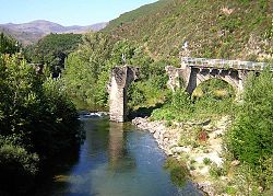
 old Golo bridge near Castello-di-Rostino | |
 | |
| Location | |
| Country | France |
| Physical characteristics | |
| Source | |
| • location | central Corsica |
| Mouth | |
• location | Tyrrhenian Sea |
• coordinates | 42°31′23″N 9°32′5″E |
| Length | 89.4 km (55.6 mi) |
Course
The Golo is 89.38 kilometres (55.54 mi) long.[1] It crosses the communes of Aiti, Albertacce, Bigorno, Bisinchi, Calacuccia, Campile, Campitello, Canavaggia, Casamaccioli, Castello-di-Rostino, Castirla, Corscia, Gavignano, Lento, Lucciana, Monte, Morosaglia, Olmo, Omessa, Piedigriggio, Prato-di-Giovellina, Prunelli-di-Casacconi, Saliceto, Valle-di-Rostino, Venzolasca, Vescovato, Vignale and Volpajola.[1]
The Golo's source is in the mountainous middle of the island, south of Monte Cinto. It flows generally northeast, through Calacuccia and Ponte-Leccia, and ends in the Tyrrhenian Sea approximately 20 kilometres (12 mi) south of Bastia, near the Bastia – Poretta Airport. Its entire course is in the Haute-Corse département.[2] The river is dammed at Calacuccia to form the Lac de Calacuccia, a hydroelectric reservoir.[3]
Hydrology
Measurements of the river flow were taken at the Volpajola [Barchetta] station from 1961 to 2021. The watershed above this station covers 926 square kilometres (358 sq mi). Annual precipitation was calculated as 506 millimetres (19.9 in). The average flow of water throughout the year was 14.8 cubic metres per second (520 cu ft/s).[4]
| Month | Flow |
|---|---|
| Jan | 20.60 |
| Feb | 21.60 |
| Mar | 24.90 |
| Apr | 25.10 |
| May | 20.20 |
| Jun | 8.350 |
| Jul | 3.340 |
| Aug | 2.720 |
| Sep | 3.960 |
| Oct | 8.510 |
| Nov | 17.20 |
| Dec | 21.80 |
Tributaries
The following streams (ruisseaux) are tributaries of the Golo, ordered by length:[1]
- Asco 34 kilometres (21 mi)
- Casaluna 25 kilometres (16 mi)
- Bornalinco 12 kilometres (7.5 mi)
- Erco 11 kilometres (6.8 mi)
- Viru 10 kilometres (6.2 mi)
- Canavaghiola 9 kilometres (5.6 mi)
- Sumano 8 kilometres (5.0 mi)
- Vadone 8 kilometres (5.0 mi)
- Casacconi 7 kilometres (4.3 mi)
- Ruda 7 kilometres (4.3 mi)
- Acqua Fredda 6 kilometres (3.7 mi)
- Casa Murella 6 kilometres (3.7 mi)
- Ruggi 6 kilometres (3.7 mi)
- Pedicinque 6 kilometres (3.7 mi)
- Sanguinelli 6 kilometres (3.7 mi)
- Fosse de Ciavattone 6 kilometres (3.7 mi)
- Frascaghiu 5 kilometres (3.1 mi)
- Pruniccia 5 kilometres (3.1 mi)
- Petra Laccia 5 kilometres (3.1 mi)
- Novella 5 kilometres (3.1 mi)
- Pinzalone 5 kilometres (3.1 mi)
- Volta 5 kilometres (3.1 mi)
- Colga 5 kilometres (3.1 mi)
- Furignone 4 kilometres (2.5 mi)
- Stretto 4 kilometres (2.5 mi)
- Puretello 4 kilometres (2.5 mi)
- Forcione 4 kilometres (2.5 mi)
- Chiarasgiu 4 kilometres (2.5 mi)
- Arenucciu 4 kilometres (2.5 mi)
- Fiuminale 4 kilometres (2.5 mi)
- Vergalellu 4 kilometres (2.5 mi)
- Coticcio 4 kilometres (2.5 mi)
- l'Oia 4 kilometres (2.5 mi)
- Noceto 4 kilometres (2.5 mi)
- Ruisseau du Castellu 3 kilometres (1.9 mi)
- Falconaia 3 kilometres (1.9 mi)
- Sughilia 3 kilometres (1.9 mi)
- Lavertacce 3 kilometres (1.9 mi)
- Vergalone 3 kilometres (1.9 mi)
- Campo Piano 3 kilometres (1.9 mi)
- Ravin de Teghiamara 3 kilometres (1.9 mi)
- Corniolo 3 kilometres (1.9 mi)
- Maltempu 3 kilometres (1.9 mi)
- Buffardu 3 kilometres (1.9 mi)
- Canneto 3 kilometres (1.9 mi)
- Murato 3 kilometres (1.9 mi)
- Sualello 3 kilometres (1.9 mi)
- Catamalzi 3 kilometres (1.9 mi)
- Padule 3 kilometres (1.9 mi)
- Mazzone 2 kilometres (1.2 mi)
- Valde Calze 2 kilometres (1.2 mi)
- Volte 2 kilometres (1.2 mi)
- Cipetto 2 kilometres (1.2 mi)
- Catarette et de Lagiarone 2 kilometres (1.2 mi)
- Silvagnolo 2 kilometres (1.2 mi)
- Ciattarinu 2 kilometres (1.2 mi)
- Alzitana 2 kilometres (1.2 mi)
- Monticello 2 kilometres (1.2 mi)
- Balliccione 2 kilometres (1.2 mi)
- Curtinche 2 kilometres (1.2 mi)
- Mulinellu 2 kilometres (1.2 mi)
- Valliccone 2 kilometres (1.2 mi)
- Finosella 2 kilometres (1.2 mi)
- Scopette 2 kilometres (1.2 mi)
- Alzetu 2 kilometres (1.2 mi)
- Cruma 2 kilometres (1.2 mi)
- Fornello 2 kilometres (1.2 mi)
- Poggie 2 kilometres (1.2 mi)
- Piedilorso 2 kilometres (1.2 mi)
- la Via Secca 2 kilometres (1.2 mi)
- Tornaroio 2 kilometres (1.2 mi)
- Ficaiola 2 kilometres (1.2 mi)
- Novella 2 kilometres (1.2 mi)
- Becchittacci 2 kilometres (1.2 mi)
- Sialari 2 kilometres (1.2 mi)
- Quercitane 2 kilometres (1.2 mi)
- Falconaia 1 kilometre (0.62 mi)
- Vetrice 1 kilometre (0.62 mi)
- Mitalle 1 kilometre (0.62 mi)
- Favale 1 kilometre (0.62 mi)
- Zuffello 1 kilometre (0.62 mi)
- Funtana Secca 1 kilometre (0.62 mi)
- Paratella 1 kilometre (0.62 mi)
- l'Ortone 1 kilometre (0.62 mi)
- Funtana Secca 1 kilometre (0.62 mi)
- Cannella 1 kilometre (0.62 mi)
- Piubbiche 1 kilometre (0.62 mi)
- Favalello 1 kilometre (0.62 mi)
- Chiarasgioli 1 kilometre (0.62 mi)
- Casella 1 kilometre (0.62 mi)
References
Sources
- "Le Golo à Volpajola [Barchetta]", eaufrance (in French), Ministère de l'Ecologie, du Développement Durable et de l'Energie, archived from the original on 2011-03-01, retrieved 2021-12-17
- "Le Golo", Sandre (in French), retrieved 2021-12-17
- "Relation: Le Golo (2805254)", OpenStreetMap, retrieved 2021-12-17
- "Retenue de Calacuccia", Sandre (in French), retrieved 2021-12-12
На других языках
[de] Golo (Korsika)
Der Golo (korsisch: Golu) ist ein Fluss in Frankreich, der im Département Haute-Corse auf der Insel Korsika verläuft. Er entspringt im Regionalen Naturpark Korsika (Parc naturel régional de Corse), an der Süd-Flanke des Capu Tafunatu (2335 m), im Gemeindegebiet von Albertacce, entwässert generell in Richtung Nordost bis Ost und mündet nach rund 89[2] Kilometern an der Gemeindegrenze von Lucciana und Vescovato ins Tyrrhenische Meer.- [en] Golo (river)
[es] Río Golo
El río Golo es el mayor río de la isla de Córcega (Francia). Nace a unos 2000 msnm, en el macizo de Paglia Orba. Desemboca en el mar Tirreno, al sur del Étang de Biguglia. Su longitud es de 89,60 km.[it] Golo
Il Golo (in corso Golu) è il più lungo fiume della Corsica con oltre 89 km di percorso. Scorre interamente nel territorio del dipartimento della Alta Corsica.[ru] Голо
Голо (фр. Golo, корс. Golu) — крупнейшая река Корсики.Другой контент может иметь иную лицензию. Перед использованием материалов сайта WikiSort.org внимательно изучите правила лицензирования конкретных элементов наполнения сайта.
WikiSort.org - проект по пересортировке и дополнению контента Википедии


