geo.wikisort.org - Mountains
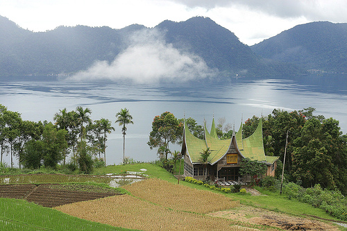
Lake Maninjau (Indonesian: Danau Maninjau, meaning "overlook" or "observation" in the Minangkabau language) is a caldera lake in West Sumatra, Indonesia. It is located 36 kilometres (22 mi) to the west of Bukittinggi, at 0°19′S 100°12′E.
| Maninjau | |
|---|---|
| Danau Maninjau (Indonesian) دانااو مانينجاو (Jawi) | |
 | |
 Maninjau | |
| Location | West Sumatra, Indonesia |
| Coordinates | 0°19′S 100°12′E |
| Type | Caldera lake |
| Primary outflows | Antokan River |
| Basin countries | Indonesia |
| Max. length | 16 km (9.9 mi) |
| Max. width | 7 km (4.3 mi) |
| Surface area | 99.5 km2 (38.4 sq mi) |
| Average depth | 105 m (344 ft) |
| Max. depth | 165 m (541 ft) |
| Water volume | 10.4 km3 (8,400,000 acre⋅ft) |
| Shore length1 | 52.68 km (32.73 mi) |
| Surface elevation | 459 m (1,506 ft) |
| 1 Shore length is not a well-defined measure. | |
Formation
The Maninjau caldera was formed by a volcanic eruption estimated to have occurred around 52,000 years ago.[1] Deposits from the eruption have been found in a radial distribution around Maninjau extending up to 50 kilometres (31 mi) to the east, 75 kilometres (47 mi) to the southeast, and west to the present coastline. The deposits are estimated to be distributed over 8,500 square kilometres (3,300 sq mi) and have a volume of 220–250 cubic kilometres (53–60 cu mi).[2] The caldera has a length of 20 kilometres (12 mi) and a width of 8 kilometres (5.0 mi).[1]
The lake
Lake Maninjau has an area of 99.5 square kilometres (38.4 sq mi), being approximately 16 kilometres (9.9 mi) long and 7 kilometres (4.3 mi) wide. The average depth is 105 metres (344 ft), with a maximum depth of 165 metres (541 ft). The natural outlet for excess water is the Antokan river, located on the west side of the lake. It is the only lake in Sumatra which has a natural outlet to the west coast. Since 1983, this water has been used to generate hydroelectric power for West Sumatra, generated around 68 MW at maximum load.
Most of the people who live around Lake Maninjau are ethnically Minangkabau. Villages on the shores of the lake include Maninjau and Bayur.
Maninjau is a notable tourist destination in the region due to its scenic beauty and mild climate. It is also a site for paragliding.
Local fishing and agriculture


Two endemic species collected from the lake for local consumption and for export to markets outside the crater are pensi, a species of small mussel, and palai rinuak, a type of small fish. One method of preparing palai rinuak is to grill a mixture of the fish along with coconut and spices, wrapped in a banana leaf.
The lake is used for aquaculture, using karamba floating net cages. The technique was introduced in 1992 and, by 1997, there were over 2,000 cage units with over 600 households engaged. Each cage may have 3-4 production cycles each year. There is evidence of pollution around some karamba areas.
On the edge of the lake, land use includes rice fields in the swamps and the lower slopes. The villages are bordered uphill by a large belt of forest-like tree gardens, which dissolve into the upper montane forest on the steepest parts of the slopes up to the ridge of the caldera.[3]
The tree gardens include three typical components:[3]
- Fruit trees including durian, jack fruit, cempedak, rambutan, langsat, golden berries and water apples.
- Timber species including Toona sinensis and Pterospermum javanicum.
- Spice trees including cinnamon, coffee, nutmeg and cardamum.
Sukarno's pantun


The first president of Indonesia, Sukarno, visited the area in early June 1948. A pantun he wrote about the lake reads:[4]
Jangan dimakan arai pinang, |
Do not eat arai nut, |
See also
References
- Alloway, Brent V.; Agung Pribadi; John A. Westgate; Michael Bird; L. Keith Fifield; Alan Hogg; Ian Smith (30 October 2004). "Correspondence between glass-FT and 14C ages of silicic pyroclastic flow deposits sourced from Maninjau caldera, west-central Sumatra". Earth and Planetary Science Letters. Elsevier. 227 (1–2): 121. Bibcode:2004E&PSL.227..121A. doi:10.1016/j.epsl.2004.08.014.
- Purbo-Hadiwidjoyo, M.M.; M.L. Sjachrudin; S. Suparka (1979). "The volcano–tectonic history of the Maninjau caldera, western Sumatra, Indonesia". Geol. Mijnb (58): 193–200.
- Michon, Genevieve (2005). Domesticating forests: how farmers manage forest resources. Center for International Forestry Research (CIFOR). ISBN 979-3361-65-4.
- Burhanuddin, Jajat (2000). Ulama perempuan Indonesia. Gramedia Pustaka Utama. pp. 68–69. ISBN 979-686-644-7.
External links
 Lake Maninjau travel guide from Wikivoyage
На других языках
[de] Maninjau-See
Der Maninjau-See (indonesisch Danau Maninjau) ist ein Kratersee im Westen der indonesischen Insel Sumatra. Er liegt rund 30 Kilometer westlich von Bukittinggi.- [en] Lake Maninjau
[fr] Lac Maninjau
Le lac Maninjau (indonésien: Danau Maninjau, Meninjau signifie Observation ) est une caldeira dans la province de Sumatra occidental en Indonésie. Il est situé à 16 km à l'ouest de Bukittinggi.Другой контент может иметь иную лицензию. Перед использованием материалов сайта WikiSort.org внимательно изучите правила лицензирования конкретных элементов наполнения сайта.
WikiSort.org - проект по пересортировке и дополнению контента Википедии