geo.wikisort.org - Mountains
Kelimutu (pronounced [kəliˈmutu]) is a volcano, close to the small town of Moni in central Flores island in Indonesia. It is around 50 km (31 mi) to the east of Ende, Indonesia, the capital of Ende regency in East Nusa Tenggara province. It has three volcanic crater lakes that differ in color.
| Kelimutu | |
|---|---|
 Crater lake at Kelimutus summit | |
| Highest point | |
| Elevation | 1,639 m (5,377 ft)[1] |
| Listing | List of volcanoes in Indonesia Spesial Ribu |
| Coordinates | 8°46′S 121°49′E |
| Geography | |
 Kelimutu Kelimutu | |
| Location | Ende Regency, Flores Island, Indonesia |
| Geology | |
| Mountain type | Complex volcano |
| Last eruption | June to July 1968[1] |

The science of the Kelimutu lakes is relatively well-known,[2] and the changes in color and temperature are concluded to be related to volcanic activity and the resulting fluid flux at vents at the bottom of the lakes.[3] The Lake colors periodically change due to adjustments in the oxidation-reduction status of the fluid of each lake, and also considering the abundance of different major elements, such as iron and manganese. Oxidation-reduction status depends on the balance of volcanic gas input and rainfall rate,[4] and is thought to be mediated by the groundwater system in the volcano itself.[5] The colors in the lakes change independently from each other, as each has its own unique connectivity to the underlying volcano's activity. Between January and November 2016, the colors of the craters changed six times.[6] Although it is widely believed that the changes are unpredictable, it is more accurate to say that the lack of any regular monitoring of the volcanic system precludes scientists from having the data necessary to drive widely available predictive models.
Geological details
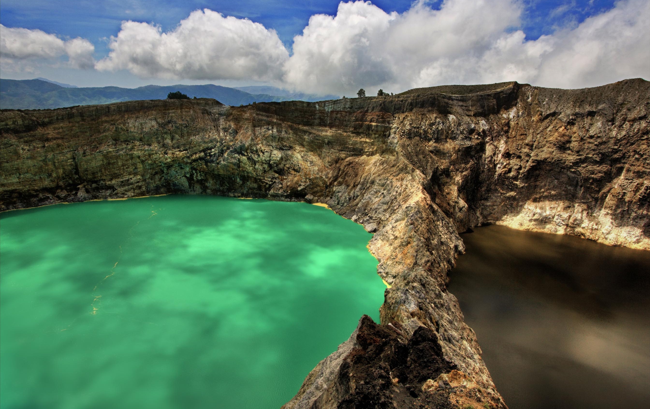
The volcano contains three striking summit crater lakes of varying colors. Tiwu Ata Bupu (Lake of Old People) is usually blue and is the westernmost of the three lakes. The other two lakes, Tiwu Ko'o Fai Nuwa Muri (Lake of Young Men and Maidens) and Tiwu Ata Polo (Bewitched or Enchanted Lake) are separated by a shared crater wall and are typically green or red respectively. The lake colors vary on a periodic basis. Subaqueous fumaroles are the probable cause of active upwelling that occurs at the two eastern lakes.[1]
The Tiwu Ko'o Fai Nuwa Muri has been a source of minor phreatic eruptions in historical time.[7] The summit of the compound 1,639 m (5,377 ft) high Kelimutu volcano is elongated 2 km (1.2 mi) in a WNW-ESE direction; the older cones of Kelido and Kelibara are located respectively 3 km (1.9 mi) to the north and 2 km (1.2 mi) to the south.[8] The scenic lakes are a popular tourist destination.[9]
Kelimutu is also of interest to geologists, because the three lakes have different colors, yet are at the crest of the same volcano.[10] According to Kelimutu National Park officials, the colour changes as a result of chemical reactions resulting from the minerals contained in the lake perhaps triggered by volcano gas activity.[11] However, it is more accurate to refer to the color changes as being driven by oxidation-reduction chemical dynamics. Kawah Putih lake in West Java, south of Bandung, is another crater lake in Indonesia with some similarities to the lakes at Kelimutu.
Tourism
In the early days of developing the local national park in the Kelimutu area, there were some disputes with local communities over the use of the resources. More recently, forest rangers have worked to develop better relations with nearby village communities and overall management has improved.[12]
Kelimutu is one of the mountains listed as a ribu in Indonesia which are mountains in Indonesia which are more than 1,000 metres (3,281 ft) high.
The area is said to have begun to attract attention after being noticed by a regional Dutch military commander, B. van Suchtelen in 1915 and became more well known after Y. Bouman wrote about the site in 1929.[13]
The closest airports are Maumere, and Ende. There are regular flights to Ende from Bali. The drive from Ende to Moni, the town at the base of Kelimutu where accommodation is available, takes about 3 hours, while from Moni to Kelimutu vehicle park, a 13 kilometres (8.1 mi) drive, needs 45 minutes.[14] Usually tourists sleep one night to catch sunrise at Kelimutu.
Local Culture
Kelimutu is sacred to the local Lio people, who believe the souls of the dead migrate here. Young people’s souls go to the warmth of Tiwu Koo Fai Nuwa Muri (Lake of Young Men and Maidens), old people’s to the cold of Tiwu Ata Bupu (Lake of Old People), and those of the wicked to Tiwu Ata Polo (Bewitched or Enchanted Lake). Pork, betel nuts, rice and other valuable offerings are left on ceremonial rocks beside the lakes, amid the dancing of the Lio's annual 'Feed the Spirit of the Forefathers' ceremony, on August 14.[15]
See also
- Kelimutu National Park
- List of volcanoes in Indonesia
Gallery
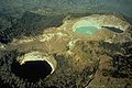 Arial view from the krater lakes, at the lower left is the Tiwu Ata Mbupu (Lake of Old People), at the upper cen Tiwu Ko'o Fai Nuwa Muri (Lake of Young Men and Maiden) and Tiwu Ata Polo (Bewitched, or Enchanted Lake) at the upper right.
 Tiwu Ko'o Fai Nuwa Muri and Tiwu Ata Polo
 Tiwu Ata Polo (Bewitched, or Enchanted Lake)
 Tiwu Ko'o Fai Nuwa Muri and Tiwu Ata Polo
 Tiwu Ata Bupu (Lake of Old People)


References
- "Kelimutu". Global Volcanism Program. Smithsonian Institution.
- "Dr. Gregory B. Pasternack - Watershed Hydrology, Geomorphology, and Ecohydraulics :: Keli Mutu". pasternack.ucdavis.edu. Retrieved 2017-06-11.
- Murphy, Sam; Wright, Robert; Rouwet, Dmitri (January 2018). "Color and temperature of the crater lakes at Kelimutu volcano through time". Bulletin of Volcanology. 80 (1): 2. doi:10.1007/s00445-017-1172-2. ISSN 0258-8900.
- Pasternack, Gregory B.; Varekamp, Johan C. (1997-05-01). "Volcanic lake systematics I. Physical constraints". Bulletin of Volcanology. 58 (7): 528–538. doi:10.1007/s004450050160. ISSN 0258-8900.
- Pasternack, G. B. 1993. Acid-brine crater lake systematics: a case study. Undergraduate High Honors thesis. Wesleyan University, 160 pp, 4 appendices. DOI: 10.13140/RG.2.1.3414.1040.
- Markus Makur (November 24, 2016). "Kelimutu lakes change color for the 6th time this year".
- "Kelimutu Volcano". www.photovolcanica.com. Retrieved 2022-06-28.
- Herrick, Julie. (2013). Nevado del Tolima (Colombia): Non-eruptive activity during 2005-2012: hazard assessment and glacial retreat. Bulletin of Global Volcanism Network. 38. 27.
- 'Kelimutu: Adventure to the Three coloured lakes', Accessed 29 April 2012.
- Pasternack, Gregory B.; Johan C. Varekamp (1994). "The geochemistry of the Keli Mutu crater lakes, Flores, Indonesia" (PDF). Geochemical Journal. 28 (3): 243–262. doi:10.2343/geochemj.28.243. Here's a link to the abstract
- Some details of the characteristics of volcanic soils in the area can be found at Hikmatullah, H. Subagyo, and B.H. Prasetyo, 'Soil properties of the eastern toposequence of Mount Kelimutu, Flores Island, East Nusa Tenggara and their potential for agricultural use'[permanent dead link], Indonesian Jour. of Agricultural Science, 4(1), 2003, pp. 1-11.
- Tifa Asrianti, 'Locals help protect Kelimutu national park', The Jakarta Post, 4 January 2011.
- Gagas Ulung (2011), Exotic NTT: 200 tempat paling menantang dan eksotis di provinsi Nusa Tenggara Timur: wisata alam, bahari, budaya, dan tradisi [Exotic NTT: 200 of the most challenging and exotic places in Nusa Tenggara Timur: tourism for nature, the sea, culture, and tradition], PT Gramedia Pustaka Utama, Jakarta, p. 184.
- Tri Hatma Ningsih (June 23, 2014). "Tiga Warna Sejuta Pesona".
- "Kelimutu National Park | Indonesia Attractions". Lonely Planet. Retrieved 2022-06-28.
External links
 Kelimutu travel guide from Wikivoyage
- Volume 28, No. 3, pp. 137-306 of the Geochemical Journal is a special issue of the journal dedicated to Volcanic lakes.
На других языках
[de] Kelimutu (Berg)
Der Kelimutu ist ein 1639 m hoher Vulkan auf der indonesischen Insel Flores, der wegen seiner drei verschiedenfarbigen Kraterseen ein beliebtes Touristenziel ist.- [en] Kelimutu
[es] Monte Kelimutu
Kelimutu (pronunciado [kəlimutu]) es un volcán, cerca de la pequeña ciudad de Moni en el centro de la isla de Flores en Indonesia. Se sitúa a unos 50 km al este de Ende, Indonesia, capital de la regencia de Ende en la provincia de Nusa Tenggara Oriental. Tiene tres lagos de cráter volcánicos de diferentes colores.[fr] Kelimutu
Le Kelimutu est un volcan au centre de l'île de Florès dans le Sud de l’Indonésie.[ru] Келимуту
Келимуту (индон. Kelimutu) — вулкан на индонезийском острове Флорес высотой в 1639 м. Из-за трёх кратерных озёр, из которых каждое окрашено в свой цвет, Келимуту является популярной туристической достопримечательностью. Последнее известное извержение имело место в 1968 году.Другой контент может иметь иную лицензию. Перед использованием материалов сайта WikiSort.org внимательно изучите правила лицензирования конкретных элементов наполнения сайта.
WikiSort.org - проект по пересортировке и дополнению контента Википедии