geo.wikisort.org - Island
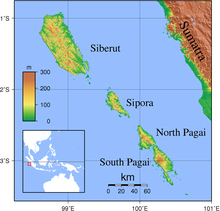
The Mentawai Islands Regency are a chain of about seventy islands and islets approximately 150 kilometres (93 miles) off the western coast of Sumatra in Indonesia. They cover 6,033.76 km2 and had a population of 76,173 at the 2010 Census and 87,623 at the 2020 Census.[3] Siberut at 3,838.25 square kilometres (1,482 square miles) is the largest of the islands. The other major islands are Sipura (or Sipora), North Pagai (Pagai Utara), and South Pagai (Pagai Selatan). The islands lie off the Sumatran coast, across the Mentawai Strait. The indigenous inhabitants of the islands are known as the Mentawai people. The Mentawai Islands have become a noted destination for surfing,[4] with over 40 boats offering surf charters to international guests.[5]
Mentawai Islands Regency
Kabupaten Kepulauan Mentawai | |
|---|---|
Regency | |
|
Coat of arms | |
 Location within West Sumatra | |
 Mentawai Islands Regency Location in Sumatra and Indonesia  Mentawai Islands Regency Mentawai Islands Regency (Indonesia) | |
| Coordinates: 2°11′S 99°39′E | |
| Country | Indonesia |
| Province | West Sumatra |
| Regency seat | Tua Pejat |
| Government | |
| • Regent | Yudas Sabaggalet |
| • Vice Regent | Kortanius Sabeleake |
| Area | |
| • Total | 6,033.76 km2 (2,329.65 sq mi) |
| Population (2020 Census)[1] | |
| • Total | 87,623 |
| • Density | 15/km2 (38/sq mi) |
| Demographics | |
| • Religion | Christianity 79,94% - Protestanism 49% - Catholicism 30,94% Islam 19,56% |
| Time zone | UTC+7 (Indonesia Western Standard Time) |
| Area code | (+62) 759 |
| Website | mentawaikab.go.id |
Administrative districts


The Mentawai Islands have been administered as a regency within the West Sumatra (Sumatera Barat) province since 1999. The regency seat is Tua Pejat, on the island of Sipora. Padang, the capital of the province, lies on the Sumatran mainland opposite Siberut. The regency is divided into ten districts (kecamatan), tabulated below from south to north with their areas and their populations at the 2010 Census[6] and the 2020 Census.[7] The table also includes the locations of the district administrative centres, the number of villages (rural desa and urban kelurahan) in each district, and its post code.
| District | English Name | Area in km2 | Population 2010 Census | Population 2020 Census | Administrative centre | No. of villages | Post code |
|---|---|---|---|---|---|---|---|
| Pagai Selatan | South Pagai | 851.28 | 8,782 | 9,373 | Bulasat | 4 | 25391 |
| Sikakap (a) | Central Pagai | 312.60 | 9,531 | 10,219 | Taikako | 3 | 25399 |
| Pagai Utara | North Pagai | 371.25 | 5,212 | 6,031 | Saumanganya | 3 | 25390 |
| Sipora Selatan | South Sipora | 348.33 | 8,460 | 9,812 | Sioban | 7 | 25392 |
| Sipora Utara | North Sipora | 272.40 | 9,097 | 11,968 | Sido Makmur | 6 | 25398 |
| Siberut Selatan | South Siberut | 328.00 | 8,446 | 9,933 | Muara Siberut | 5 | 25397 |
| Siberut Barat Daya | Southwest Siberut | 1,013.83 | 6,069 | 7,058 | Pasakiat Taileleu | 3 | 25393 |
| Siberut Tengah | Central Siberut | 589.75 | 6,069 | 7,089 | Saibi Samukop | 3 | 25396 |
| Siberut Utara | North Siberut | 782.68 | 7,774 | 8,337 | Muara Sikabaluan | 6 | 25395 |
| Siberut Barat | West Siberut | 1,163.64 | 6,733 | 7,803 | Simalegi | 3 | 25394 |
| Totals | 6,033,76 | 76,173 | 87,623 | Tuapejat | 43 |
Note: (a) Sikakap District covers the northern part of South Pagai Island and the southern part of North Pagai Island, plus some intervening small islands.
Villages
Administrative villages (desa) listed for each district:[8]
| District | Villages |
|---|---|
| Pagai Selatan | Bulasat, Makalo, Malakopa (Malakopak), Sinaka (Sinakak) |
| Sikakap | Matobe (Matobek), Sikakap, Taikako |
| Pagai Utara | Betumonga, Saumanganya (Saumanganyak), Silabu |
| Sipora Selatan | Beriulou, Bosua, Mara, Matobe (Matobek), Nemnemleleu (Nem-Nem Leleu), Saureinu (Saureinuk), Sioban |
| Sipora Utara | Betumonga (Beutomonga), Bukit Pamewa, Gosooinan (Goisooinan), Sido Makmur, Sipora Jaya, Tuapejat |
| Siberut Selatan | Madobag (Madobak Ugai), Maileppet/Maleppet, Matotonan, Muara/Muaro Siberut, Muntei |
| Siberut Barat Daya | Katurai/Katurei, Pasakiat Taileleu (Pasakiat Taleleu), Sagulubbeg (Sagulubek / Sagalubeg / Sagalubbek) |
| Siberut Tengah | Cimpungan, Saibi Muara (Saibi Samukop/Samokop), Saliguma |
| Siberut Utara | Bojakan, Malancan (Malancang), Mongan Poula/Paula, Muara/Muaro Sikabaluan, Sirilogui, Sotboyak |
| Siberut Barat | Sigapokna, Simalegi/Simaligi, Simatalu Sipokak |
Tourism
Surfing
The first photos of the surf breaks in the Mentawais area were leaked after a surf trip in 1992 aboard the MV Indies Trader, with professional surfers Ross Clarke-Jones, Tom Carroll, and Martin Potter.[9] Ever since then, the Mentawai Islands have been well on the radar of surf travellers around the world. At the West of Sumatra, the Mentawai Islands have the most consistent surf breaks in Indonesia making it one of the preferred choices for serious surfers. The tropical waters surrounding the islands offer year-round waves up to 15 ft (4.5 m).[10][11]
Ecology

The islands have been separated from Sumatra since the mid-Pleistocene period, which has allowed at least twenty endemic species to develop amongst its flora and fauna. This includes six endemic primates: the Kloss's gibbon (Hylobates klossii), Mentawai macaque (Macaca pagensis), Siberut macaque (Macaca siberu), Mentawai langur (Presbytis potenziani), Siberut langur (Presbytis siberu), and pig-tailed langur (Simias concolor). They are highly endangered due to logging, unsustainable hunting, and conversion of rainforest to palm oil plantations.[12] Some areas of the Mentawai Islands rainforest ecoregion are protected, such as the Siberut National Park. Red junglefowl, the Asian palm civet and crab-eating macaque are also native.[13]
Seismic activity

The Mentawai Islands lie above the Sunda megathrust, a seismically active zone responsible for many great earthquakes. This megathrust runs along the southwestern side of Sumatra island, forming the interface between the Eurasian Plate and Indo-Australian Plate.
Earthquake and tsunami activity has been high since the 2004 Indian Ocean earthquake. In 1833, the region was hit with an earthquake, possibly similar in size to the 2004 Indian Ocean earthquake;[14] another large earthquake struck in 1797. On October 25, 2010, an earthquake in southern Sumatra led to a deadly tsunami that devastated villages in South and North Pagai.[15] On March 3, 2016, an earthquake of 7.8 magnitude occurred off the Indian Ocean, a few hundred kilometres from Mentawai islands, as a result of strike-slip faulting within the oceanic lithosphere of the Indo-Australia plate.[16]
See also
- Mentawai ethnic group
- Mentawai Festival
Notes
- Badan Pusat Statistikm Jakarta, 2021.
- "Penduduk Menurut Wilayah dan Agama yang Dianut Provinsi Sumatera Barat". sp2010.bps.go.id. Retrieved 2021-07-26.
- Badan Pusat Statistik, Jakarta, 2021.
- "SURFAID". SURFAID. Archived from the original on May 17, 2014. Retrieved May 3, 2017.
- "Every Surf Charter Boat in the Mentawais | 41 Boats with Photos and Info". Indies Trader. Retrieved 2019-05-05.
- Biro Pusat Statistik, Jakarta, 2011.
- Badan Pusat Statistik, Jakarta, 2021.
- "Daftar Desa & Kelurahan di Kabupaten Kepulauan Mentawai". www.nomor.net. Kode Pos Indonesia. 2020. Retrieved 2020-02-25.
- "Mentawai". www.surfindonesia.com. Retrieved 2020-12-18.
- "Top 10 Place to Surf in Indonesia". allindonesiatravel. Retrieved 2020-12-18.
- "15 Surfing Destination". indonesia.travel. Retrieved 2020-12-18.
- Whittaker, D. 2006. A conservation action plan for the Mentawai primates. Primate Conservation 20: 95–105.
- "Mentawai Islands rain forests". Terrestrial Ecoregions. World Wildlife Fund.
- "INDONESIA - THE GREAT EARTHQUAKE AND TSUNAMI OF 1833 OFF THE COAST OF CENTRAL SUMATRA - Dr. George Pararas-Carayannis". www.DrGeorgePC.com. Retrieved May 3, 2017.
- "Indonesia Earthquake and Tsunami Kill 113, Merapi Volcano Eruptions Hours Later". News article. politiktimes.com. October 26, 2010. Archived from the original on November 5, 2010. Retrieved October 26, 2010.
- "M7.8 – Southwest of Sumatra, Indonesia". Retrieved March 2, 2016.
External links
Regencies and cities of West Sumatra | ||
|---|---|---|
Capital: Padang | ||
| Regencies |  | |
| Cities |
| |
See also: List of regencies and cities of Indonesia | ||
Authority control | |
|---|---|
| General |
|
| National libraries | |
На других языках
[de] Mentawai-Inseln
Die Mentawai-Inseln sind eine zu Indonesien gehörige Inselgruppe südwestlich von Sumatra. Sie gehören zur Provinz Westsumatra.- [en] Mentawai Islands Regency
[es] Islas Mentawai
Las islas Mentawai son un pequeño archipiélago de islas volcánicas de Indonesia localizado a unos 150 km de la parte central de la costa occidental de la isla de Sumatra, de la que la separan las aguas del estrecho de Mentawai; se localizan al sur de las islas Batu. Es un claro ejemplo de arco insular.[it] Isole Mentawai
Le Isole Mentawai sono una catena di isole disposte parallelamente alla costa occidentale di Sumatra, nel suo tratto centrale, a circa 150 km di distanza. L'arcipelago comprende una settantina di isolotti e quattro isole di grandi dimensioni: Siberut (4030 km²), che è la maggiore, Sipora, che è la più piccola delle quattro (845 km²), Pagai del nord (Pagai Utara) e Pagai del sud (Pagai Selatan). Le isole sono separate da Sumatra dallo Stretto delle Mentawai.[ru] Ментавай (острова)
Ментава́й[1] (индон. Kepulauan Mentawai) — принадлежащая Индонезии группа из около 70 островов, расположенная в 130 км к юго-западу от Суматры и относящаяся к провинции Западная Суматра. Общая площадь островов составляет около 6100 км²[2], а население — 76 421 человек (2010). Более крупными из Ментавайских островов являются Сиберут (4030 км²), Сипора (845 км²), Пагай-Утара (622 км²) и Пагай-Селатан (900 км²). Плантации каучуконосов и кокосовой пальмы.Другой контент может иметь иную лицензию. Перед использованием материалов сайта WikiSort.org внимательно изучите правила лицензирования конкретных элементов наполнения сайта.
WikiSort.org - проект по пересортировке и дополнению контента Википедии