geo.wikisort.org - Island
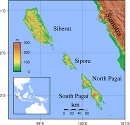
South Pagai (Indonesian: Pagai Selatan) is one of the Mentawai Islands of the west coast of Sumatra in Indonesia. The island is south of North Pagai (or Pagai Utara) Island. The population figure given for South Pagai in the box to the right is for South Pagai District alone; the south portion of Sikakap District (which covers the southern part of North Pagai Island and the northern part of South Pagai Island, together with various small islands in the strait between the two) is largely unpopulated.
 | |
| Geography | |
|---|---|
| Location | South East Asia |
| Coordinates | 3°00′S 100°20′E |
| Archipelago | Mentawai Islands |
| Area | 860.88 km2 (332.39 sq mi) |
| Administration | |
Indonesia | |
| Province | West Sumatra |
| Regency | Mentawai Islands |
| Demographics | |
| Population | 9,373 (2020 Census) |
| Pop. density | 10.9/km2 (28.2/sq mi) |
The September 2007 Sumatra earthquakes were located near these islands, producing coastal uplift, enlarging nearby islands and even producing six new ones.[1] The 2010 Mentawai earthquake and tsunami also struck off its southwest coast, causing a tsunami.
 2010 Mentawai earthquake and tsunami

Surf breaks
This article contains wording that promotes the subject in a subjective manner without imparting real information. (August 2021) |
South Pagai and its surrounding outer islands include surf breaks. The surf breaks in this region were affected during the 2007 seismic event where the reefs raised around 6 feet in the southernmost tip of Mentawai. Due to this, the surf breaks were altered, and new surf breaks were added.
The breaks in the area include:
- "Roxy's Right" (a.k.a. Coldsprings),
- "Rag's Left",
- "Rag's Right",
- "Buddha's Left",
- "Thunders Left",
- "Thunders Right",
- "Yellowstones Left and Right"(a.k.a. "IDK's" a.k.a. "Dracula's"),
- "Bangkok's Left",
- "Lighthouse Rights",
- "McFrights Left" (a.k.a. "Hole"),
- "Moots",
- "Sneaky Peak",
- "Meat Locker"
Breaks are currently accessible by surf charter boat only, and due to the distance required to travel to the South Pagai region, they are frequented by fewer operators.
References
- (in Japanese) Southern Sumatra Earthquake in 2007, coastal change, GSI
This West Sumatra location article is a stub. You can help Wikipedia by expanding it. |
На других языках
[de] Südpagai
Südpagai (indonesisch Pagai Selatan) ist Teil der Mentawai-Inseln, eine zu Indonesien gehörige Inselgruppe rund 130 Kilometer südwestlich von Sumatra.- [en] South Pagai
[it] Pagai del sud
Pagai del sud (in indonesiano Pagai Selatan) è un'isola dell'Indonesia occidentale, appartenente all'arcipelago delle isole Mentawai localizzate a 150 km ad ovest di Sumatra e separate da questa dallo stretto delle Mentawai. Buona parte dell'isola è coperta da foresta pluviale.[ru] Пагай-Селатан
Па́гай-Села́тан[1][2] (индон. Pulau Pagai Selatan) — один из островов Ментавай, лежащих к западу от центральной части Суматры в Индийском океане. В административном отношении является частью индонезийской провинции Западная Суматра.Другой контент может иметь иную лицензию. Перед использованием материалов сайта WikiSort.org внимательно изучите правила лицензирования конкретных элементов наполнения сайта.
WikiSort.org - проект по пересортировке и дополнению контента Википедии