geo.wikisort.org - Mountains
Katla (Icelandic pronunciation: [ˈkʰahtla] (![]() listen)) is a large volcano in southern Iceland. It is very active; twenty eruptions have been documented between 930 and 1918, at intervals of 20–90 years. It has not erupted violently for 104 years, although there may have been small eruptions that did not break the ice cover, including ones in 1955,[1] 1999,[2] and 2011.[3]
listen)) is a large volcano in southern Iceland. It is very active; twenty eruptions have been documented between 930 and 1918, at intervals of 20–90 years. It has not erupted violently for 104 years, although there may have been small eruptions that did not break the ice cover, including ones in 1955,[1] 1999,[2] and 2011.[3]
| Katla | |
|---|---|
 Katla eruption, 1918 | |
| Highest point | |
| Elevation | 1,512 m (4,961 ft)[1] |
| Listing | List of volcanoes in Iceland |
| Coordinates | 63°38′N 19°03′W |
| Geography | |
 Katla Iceland | |
| Geology | |
| Mountain type | Subglacial volcano |
| Last eruption | October to November 1918 |
Prior eruptions have had a Volcanic Explosivity Index (VEI) of between 4 and 6 on a scale of 0 to 8. In comparison, the Eyjafjallajökull 2010 eruption had a VEI of 4. Bigger VEI-5 eruptions are comparable to Mount St. Helens 1980 eruption, while significantly rarer VEI-6 eruptions would be comparable to Krakatoa's 1883 eruption and Mount Pinatubo's 1991 eruption.
Katla is one of the largest volcanic sources of carbon dioxide (CO2) on Earth, accounting for up to 4% of total global volcanic carbon dioxide emissions.[4]
Geography and physical appearances
Katla is one of the largest volcanoes in Iceland.[5] It is situated to the north of Vík í Mýrdal and to the east of the smaller glacier Eyjafjallajökull. Its peak reaches 1,512 metres (4,961 ft) and is partially covered by the Mýrdalsjökull glacier. The system has an area of 595 km2 (230 sq mi). The Eldgjá canyon is part of the same volcanic system.[6][7]
The caldera of the Katla volcano has a diameter of 10 km (6.2 mi) and is covered with 200–700 metres (660–2,300 ft) of ice. The volcano normally erupts every 40–80 years.[5] The flood discharge at the peak of an eruption in 1755 has been estimated at 200,000–400,000 m3/s (7.1–14.1 million cu ft/sec), comparable to the combined average discharge of the Amazon, Mississippi, Nile, and Yangtze rivers (about 266,000 m3/s (9.4 million cu ft/sec)).
Etymology
The name Katla derives from the word ketill ("kettle"), referring to the form of the volcano. Katla is also used as a female first name.[8]
Prehistoric activity
It is thought that Katla is the source of Vedde Ash,[9] more than 6 to 7 cubic kilometers (1.4 to 1.7 cu mi) of tephra dated to 10,600 years BP[1][10][11][12] found at a number of sites including Vedde in Norway, Denmark, Scotland, and North Atlantic cores.
Historic activity
Sixteen eruptions have been recorded for Katla since 930. The last major eruption started on 12 October 1918 and lasted for 24 days.[13] It was likely a VEI-5 level eruption. The 1918 eruption resulted in extending the southern coast by 5 km due to laharic flood deposits. Its present dormancy is among the longest in known history.[14]
Minor (VEI-1?) eruptions occurred in:
|
Major eruptions occurred in:
|
|

Most of these eruptions resulted in glacial floods. The severe fissure eruption in 934 was one of the largest lava eruptions in the past 10,000 years.[15] Before the Hringvegur (Iceland's Ring Road) was constructed in 1974, people feared traversing the plains in front of the volcano because of the frequent jökulhlaup (or glacier bursts) and the deep river crossings. Especially dangerous was the glacier outburst that followed the eruption of 1918.
Present day activity

Katla has been showing signs of unrest since 1999, and geologists have concerns that it might erupt in the near future.[16] Particularly, monitoring has been intensified following the March 2010 eruptions of a smaller neighbouring volcano, the Eyjafjallajökull glacier.[17] The eruption of this nearby long-dormant volcano in March and April 2010 prompted fears among some geophysicists that it might trigger an eruption at the larger and more dangerous Katla.[18][19][20] In the past 1,000 years, all three known eruptions of Eyjafjallajökull have triggered subsequent Katla eruptions.[19]
Following the 2010 Eyjafjallajökull eruptions, on 20 April 2010 Icelandic President Ólafur Grímsson said "the time for Katla to erupt is coming close ... we [Iceland] have prepared ... it is high time for European governments and airline authorities all over Europe and the world to start planning for the eventual Katla eruption".[21]
Increased earthquake activity has been noticed on Katla since the eruption at Eyjafjallajökull, but no other signs of an imminent eruption have been observed. These quakes are located mainly on the northwestern rim of the caldera. On 9 October 2010, a sudden rise in harmonic tremor was observed in the stations around Katla, a sign of a possible impending eruption.[22]
As of 2010[update], volcanologists are continuing to monitor Katla, aware that any eruption from Katla following an eruption from Eyjafjallajökull has historically occurred within months of the latter. The Icelandic Meteorological Office updates its website with reports of quakes both at Eyjafjallajökull and Katla.[23]
2011 activity
In 2011, geologic activity led many to speculate that a very small subglacial eruption had taken place.[3] In June 2011, harmonic tremor was again detected at Katla volcano. A few days later, an earthquake swarm took place in the caldera, indicating magma movement inside the volcano, leading to increased fears of an eruption in the near future.[24]
On 8 and 9 July, another spike in harmonic tremors occurred, as a small eruption of Katla took place. Cracks formed on the glacier, as well as a cauldron.[25] Icelandic media reported a small subglacial eruption might have started.[26] On the morning of 9 July, a glacier flood was reported in the river Múlakvísl, and also later in the river Skálm. The bridge across Múlakvísl was destroyed as well as other parts of the road, Route 1, on the Icelandic ring road. Helicopter pilots flying over the glacier also reported cracks in the glacier.[27] Scientists monitoring the activity said speculation that it was caused by a "very small" subglacial eruption lacked confirmation by visual or seismic evidence.[3]
2016 and 2017 activity
Tremors were detected under Katla in late August 2016.[28][29]
A "Specialist Description" describing the activity on 29 August 2016 noted that there was:
... a seismic swarm in Mýrdalsjökull on the 29th of August with two events in the northern Katla caldera rim measured at magnitude 4.5. These are the biggest earthquakes in Katla volcano since 1977. Earthquake eruption checks confirmed that most earthquakes occurred between 0:40 and 1:50 PM. The big earthquakes were about thirty seconds apart at 1:47. They were followed by more than 50 aftershocks until 15:12 PM, when there was an earthquake of magnitude 3.3 and then the cycle and seismic activity in the region reduced again. No unrest was measured along these earthquakes. The geothermal has decreased in the following week and is now negligible.[30]
An update written at 11 Sep 16:38 GMT reported:
Today, shortly before 14:00, a small earthquake swarm began in Mýrdalsjökull. The largest earthquakes of the swarm were of magnitude 3.3 and 3.0 at 16:12 and 15:57. More than 10 smaller earthquakes were detected in the swarm. All of the earthquakes were shallow and located in the caldera of Katla volcano. It is not unusual for seismic swarms of this type to occur in this area.[31]
In February 2017, seismic activity at the volcano continued.[32]
Images
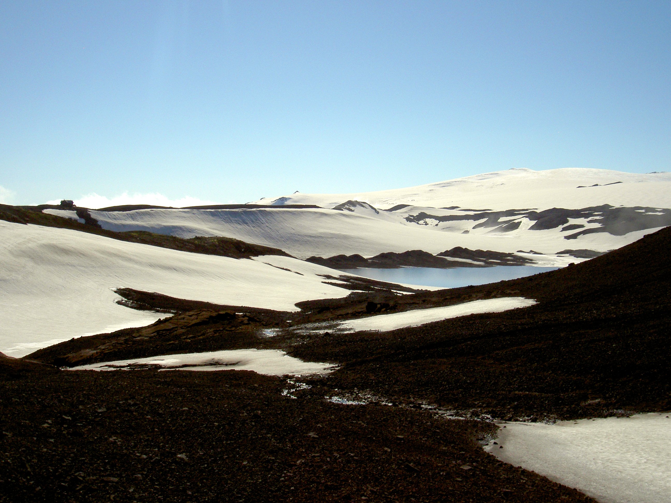
 The Mýrdalsjökull glacier in 2005
 The Mýrdalsjökull glacier in 2005

In popular culture
Katla is the subject of Katla, an Icelandic TV series produced for Netflix.
See also
- Glacial lake outburst flood
- Iceland hotspot
- Iceland plume
- List of glaciers of Iceland
- Volcanism of Iceland
- Ice cauldron
References
- "Katla Volcano". Institute of Earth Sciences. University of Iceland. Archived from the original on 9 November 2009. Retrieved 12 March 2010.
- "1999 Eruption, jökulhlaup". Retrieved 18 October 2014.
- "Katla volcano in Iceland remains dormant". IceNews. 9 July 2011. Archived from the original on 15 August 2012. Retrieved 9 July 2011.
- Ilyinskaya, Evgenia; Mobbs, Stephen; Burton, Ralph; Burton, Mike; Pardini, Federica; Pfeffer, Melissa Anne; Purvis, Ruth; Lee, James; Bauguitte, Stéphane (2018). "Globally significant CO2 emissions from Katla, a subglacial volcano in Iceland" (PDF). Geophysical Research Letters. 45 (19): 10, 332–10, 341. Bibcode:2018GeoRL..4510332I. doi:10.1029/2018gl079096. ISSN 0094-8276. S2CID 52832814.
- Budd, David A.; Troll, Valentin R.; Dahren, Börje; Burchardt, Steffi (2016). "Persistent multitiered magma plumbing beneath Katla volcano, Iceland". Geochemistry, Geophysics, Geosystems. 17 (3): 966–980. Bibcode:2016GGG....17..966B. doi:10.1002/2015GC006118. ISSN 1525-2027.
- "Katla". Global Volcanism Program. Smithsonian Institution. Retrieved 26 March 2010.
- Gudmundsson, Magnús T.; Thórdís Högnadóttir (January 2007). "Volcanic systems and calderas in the Vatnajökull region, central Iceland: Constraints on crustal structure from gravity data". Journal of Geodynamics. 43 (1): 153–169. Bibcode:2007JGeo...43..153G. doi:10.1016/j.jog.2006.09.015.
- "Katla – Nordic Names Wiki – Name Origin, Meaning and Statistics". Retrieved 18 October 2014.
- Housley, R. A.; Lane, C. S.; Cullen, V. L.; Weber, M. -J.; Riede, F.; Gamble, C. S.; Brock, F. (1 March 2012). "Icelandic volcanic ash from the Late-glacial open-air archaeological site of Ahrenshöft LA 58 D, North Germany". Journal of Archaeological Science. 39 (3): 708–716. doi:10.1016/j.jas.2011.11.003.
- Mangerud, J., Lie, S.V., Furned, H., Kristiansen, I.L., Lømo, L. (1984) A Younger Dryas Ash Bed in Western Norway, and Its Possible Correlations with Tephra in Cores from the Norwegian Sea and the North Atlantic. Quaternary Research 21 85–104
- Grönvold, K.; Oskarsson N.; Johnsen S.J.; Clausen H.B.; Hammer C.U.; Bond G.; Bard E. (1995). "Ash layers from Iceland in the Greenland GRIP ice core correlated with oceanic and land sediments". Earth Planet Sci Lett. 135 (1–4): 149–155. Bibcode:1995E&PSL.135..149G. doi:10.1016/0012-821X(95)00145-3.
- Árni Hjartarson (2003), "Postglacial Lava Production in Iceland" (PDF), in Árni Hjartarson (ed.), PhD-thesis, Geological Museum, University of Copenhagen, pp. 95–108[dead link]
- "Katla Volcano News". Retrieved 18 October 2014.
- "Archived copy". Archived from the original on 2 November 2005. Retrieved 4 May 2010.
{{cite web}}: CS1 maint: archived copy as title (link) - "Global Volcanism Program – Katla". Retrieved 18 October 2014.
- Soosalu, Heidi. "Katla seismicity". Institute of Earth Sciences. University of Iceland. Archived from the original on 4 November 2007. Retrieved 12 March 2010.
- "Hard to Predict How Long Iceland Eruption Will Last". Iceland Review. Iceland. 21 March 2010. Archived from the original on 5 June 2011. Retrieved 21 March 2010.
- Volcano erupts in south Iceland BBC online news. Retrieved 21 March 2010.
- Boyes, Roger (21 March 2010). "Iceland prepares for second, more devastating volcanic eruption". The Times. London. Retrieved 22 March 2010.
- "Icelandic Volcano May Cause Bigger Eruption". Reuters. 22 March 2010. Retrieved 20 April 2010.
- "BBC Newsnight interview with President Grímsson of Iceland, 20 April 2010". Retrieved 18 October 2014.
- Frímann, Jón. "Sudden rise in harmonic tremors around Katla and Eyjafjallajökull". Iceland Volcano and Earthquake Blog. Archived from the original on 12 October 2010. Retrieved 30 December 2010.
- "Iceland Meteorological office – Earthquakes Mýrdalsjökull, Iceland". Icelandic Meteorological office. Retrieved 18 October 2014.
- Frímann, Jón (17 June 2011). "Earthquake swarm in Katla volcano". Iceland Volcano and Earthquake Blog. Retrieved 18 October 2011.
- "Katla". Global Volcanism Program. Retrieved 18 October 2014.
- "Hlaup hafið í Múlakvísl". Morgunblaðið (in Icelandic). 9 July 2011. Retrieved 18 October 2011.
- "Sjá sprungur í jöklinum". Morgunblaðið (in Icelandic). 9 July 2011. Retrieved 18 October 2011.
- "Earthquake Activity Page". vedur.is. Icelandic Meteorological Office. Retrieved 29 August 2016.
- "Largest quakes to hit Katla volcano in decades". icelandreview.com/. Retrieved 29 August 2016.
- "11.9.2016". vedur.is. Icelandic Meteorological Office. 11 September 2016.
- "[no title cited]". vedur.is. Icelandic Meteorological Office.
- "Continuing seismic activity in the Katla volcano". Iceland Monitor. 2 February 2017.
External links
- Katla in the Catalogue of Icelandic Volcanoes
- Volcanism 1 Archived 8 December 2011 at the Wayback Machine
- University of Iceland's Institute of Earth Sciences page about Katla
- Webcams from Iceland, including Katla
- Katla: preparedness for tourists
- Icelandic Meteorological Office: Katla status
- Constantly updating map of earthquakes in Mýrdalsjökull
Glaciers of Iceland | ||
|---|---|---|
| ||
| Authority control |
|
|---|
На других языках
[de] Katla
Die Katla (.mw-parser-output .IPA a{text-decoration:none}ˈkʰahtla) ist einer der aktivsten Vulkane in Island. Er liegt unter dem Gletscherschild des Mýrdalsjökull im Süden des Landes.- [en] Katla (volcano)
[es] Katla
El volcán Katla es uno de los volcanes más poderosos del sur de Islandia, localizado bajo el glaciar Mýrdalsjökull. Desde el año 930 se han documentado dieciséis erupciones del Katla, la última de las cuales tuvo lugar en 1918.[fr] Katla
Le Katla est un volcan d'Islande recouvert par le Mýrdalsjökull, une calotte glaciaire du Sud du pays. Il est situé à l'est de l'Eyjafjöll, un autre volcan considéré comme lié au Katla. Il s'agit d'un des volcans les plus actifs et des plus destructeurs d'Islande, à l'origine de plusieurs jökulhlaups.[it] Katla
Il Katla è un grande vulcano dell'Islanda, importante sia per le sue dimensioni che per l'intensità delle sue eruzioni.[ru] Катла
Ка́тла (исл. Katla — прослушать (инф.)) — вулкан на юге Исландии. Высота вулкана — 1512 м; диаметр кальдеры — 10 км. Периодичность извержений — порядка 40—80 лет. Перекрыт юго-восточной частью ледника Мирдальсйёкюдль.Другой контент может иметь иную лицензию. Перед использованием материалов сайта WikiSort.org внимательно изучите правила лицензирования конкретных элементов наполнения сайта.
WikiSort.org - проект по пересортировке и дополнению контента Википедии