geo.wikisort.org - Mountains
Krafla (Icelandic pronunciation: [ˈkʰrapla]) is a volcanic caldera of about 10 km in diameter with a 90 km long fissure zone. It is located in the north of Iceland in the Mývatn region and is situated on the Iceland hotspot atop the Mid-Atlantic Ridge, which forms the divergent boundary between the North American Plate and the Eurasian Plate. Its highest peak reaches up to 818 m and it is 2 km in depth. There have been 29 reported eruptions in recorded history.
This article needs additional citations for verification. (September 2015) |
| Krafla | |
|---|---|
 Aerial view of Krafla (mountain) and Krafla caldera with Leirhnjúkur in 2008 | |
| Highest point | |
| Elevation | 800 m (2,600 ft) |
| Coordinates | 65°44′0″N 16°47′0″W |
| Geography | |
 Krafla Location in Iceland | |
| Location | Iceland |
| Geology | |
| Mountain type | Caldera |
| Last eruption | September 1984 |
Overview

Iceland is a place where it is possible to see plate tectonics at work. It sits astride the Mid-Atlantic Ridge; the western part of the island nation is part of the roughly westward-moving North American plate, while the eastern part of the island is part of the roughly eastward-moving Eurasian Plate. The north–south axis of the Mid-Atlantic Ridge splits Iceland in two, roughly north to south. Along this ridge many of Iceland's most active volcanoes are located; Krafla is one of these.[1]
Krafla includes the crater Víti, one of two well-known craters by this name in Iceland (the other is in Askja). The Icelandic word "víti" means "hell". In former times,[when?] people[who?] often[when?] believed hell to be under volcanoes.[citation needed] Víti has a green lake inside of it.
South of the Krafla area, but not actually within the caldera is Námafjall, a mountain, beneath which is Hverir, a geothermal area with boiling mudpools and steaming fumaroles.
History
The Mývatn fires occurred between 1724 and 1729, when many of the fissure vents opened up. The lava fountains could be seen in the south of the island, and a lava flow destroyed three farms near the village of Reykjahlíð, although nobody was harmed.
Between 1975 and 1984 there was a volcanic episode within the Krafla volcano. It involved nine volcanic eruptions and fifteen uplift and subsidence events. This interrupted some of the Krafla drillfields. During these events a large magma chamber emerged. This has been identified by analysing the seismic activity.
Since 1977 the Krafla area has been the source of the geothermal energy used by a 60 MWe power station. A survey undertaken in 2006 indicated very high temperatures at depths of between 3 and 5 kilometres, and these favourable conditions led to the development of the first well from the Iceland Deep Drilling Project that found magma 2.1 km deep beneath the surface.[2]
Photogallery
 Krafla volcanic area
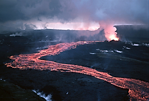
 Lava flow during a rift eruption at Krafla, 1984
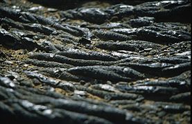 Lava ropes at Krafla, June 2007
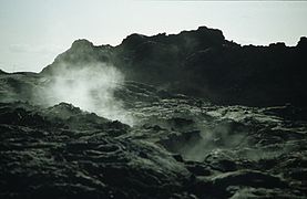 Steams at Krafla, June 2007
 Sulfur deposits at Krafla, June 2007
 A general view of Krafla, June 2007
 Mudpots at Hverir, Námafjall, August 2008
 Lava at Krafla
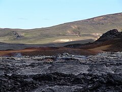 Krafla area
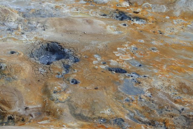
 Boiling mudpools
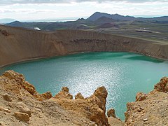 Víti crater and lake
 Small lake in Krafla


See also
- Geography of Iceland
- List of lakes of Iceland
- List of volcanoes in Iceland
- Volcanism of Iceland
- Geothermal power in Iceland
References
- Kious, W. Jacquelyne; Tilling, Robert I. (February 1996). "This Dynamic Earth: The Story of Plate Techtonics. Chapter 3: Understanding plate motions - Divergent boundaries". United States Geological Survey. USGS. Retrieved 15 January 2020.
The volcanic country of Iceland, which straddles the Mid-Atlantic Ridge, offers scientists a natural laboratory for studying on land the processes also occurring along the submerged parts of a spreading ridge. Iceland is splitting along the spreading center between the North American and Eurasian Plates, as North America moves westward relative to Eurasia.
- http://www.iddp.is/ Iceland Deep Drilling Project
External links
| Wikimedia Commons has media related to Krafla (volcanic system). |
- Krafla in the Catalogue of Icelandic Volcanoes
- "Krafla". Global Volcanism Program. Smithsonian Institution. Retrieved 2021-06-25.
- Volcanism
- Photos of Krafla and Reykjahlíð (among others)
- Univ. of Iceland: Information about Krafla
- Energy from magma at Krafla
Authority control | |
|---|---|
| General |
|
| National libraries | |
На других языках
[de] Krafla
Bei der Krafla [.mw-parser-output .IPA a{text-decoration:none}ˈkʰrapla] handelt es sich um ein Vulkansystem von ca. 100 km Länge im Norden Islands. Der gleichnamige Zentralvulkan von 818 m Höhe beherrscht mit zahlreichen Kratern die Mývatn-Region.- [en] Krafla
[fr] Krafla
Le Krafla (IPA=[ˈkʰrapla]) est une ride palagonitique (818 m d'altitude)[3] du Nord de l'Islande, éponyme d'un système volcanique appartenant au graben médian, qui comprend un volcan central caractérisé par une caldeira d'une dizaine de kilomètres de large, et un champ de fissures orientées nord-sud sur une centaine de kilomètres depuis le volcan tabulaire Selfjall au sud à la mer au nord. Ses éruptions ont façonné la topographie des environs du Mývatn.[it] Krafla
Krafla è una caldera di circa 10 km e con una fenditura lunga 90 km situata nel nord dell'Islanda nella regione di Mývatn. Il suo picco più alto misura 818 m, ha eruttato 29 volte ed è profonda 2 km.[ru] Крабла
Крабла[2] (исл. Krafla) — кальдера диаметром около 14 км, находящаяся в 90-километровой зоне рифта. Расположена в северной части Исландии, в 15 км к северо-востоку от озера Миватн. Высочайная вершина кальдеры достигает 818 метров.Другой контент может иметь иную лицензию. Перед использованием материалов сайта WikiSort.org внимательно изучите правила лицензирования конкретных элементов наполнения сайта.
WikiSort.org - проект по пересортировке и дополнению контента Википедии