geo.wikisort.org - Mountains
Jizera Mountains (Czech: Jizerské hory), or Izera Mountains (Polish: Góry Izerskie; German: Isergebirge), are part of the Western Sudetes on the border between the Czech Republic and Poland. The range got its name from the Jizera River, which rises at the southern base of the Smrk massif. The beech forests within the Jizera Mountains were added to the UNESCO World Heritage Site known as Ancient and Primeval Beech Forests of the Carpathians and Other Regions of Europe, because of their outstanding preservation and testimony to the ecological history of Europe (and the beech family specifically) since the Last Glacial Period.[1]
| Jizera Mountains | |
|---|---|
| Jizerské hory (cz), Góry Izerskie (pl) | |
 | |
| Highest point | |
| Peak | Wysoka Kopa |
| Elevation | 1,127 m (3,698 ft) |
| Coordinates | 50°51′1″N 15°25′12″E |
| Geography | |

| |
| Countries | Czech Republic and Poland |
| States | Bohemia and Lower Silesia |
| Range coordinates | 50°50′N 15°15′E |
| Parent range | Western Sudetes |
| Geology | |
| Type of rock | Granite and Basalt |
Geography

The range stretches from the Lusatian Mountains (Zittau Mountains) in the northwest to the Krkonoše in the southeast. The Jizera Mountains comprise the sources of the Jizera river, as well as of the Kwisa and the Lusatian Neisse.
The major part in the south is formed from granite, in the northern part from gneisses and mica schists, with some areas formed from basalt.
The weather conditions are characterized by above-average annual precipitation. On 30 July 1897, the measuring station at Nová Louka recorded a daily precipitation amounting to 345.1 mm (13.6 inches), still an unbroken European record.
Peaks
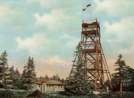
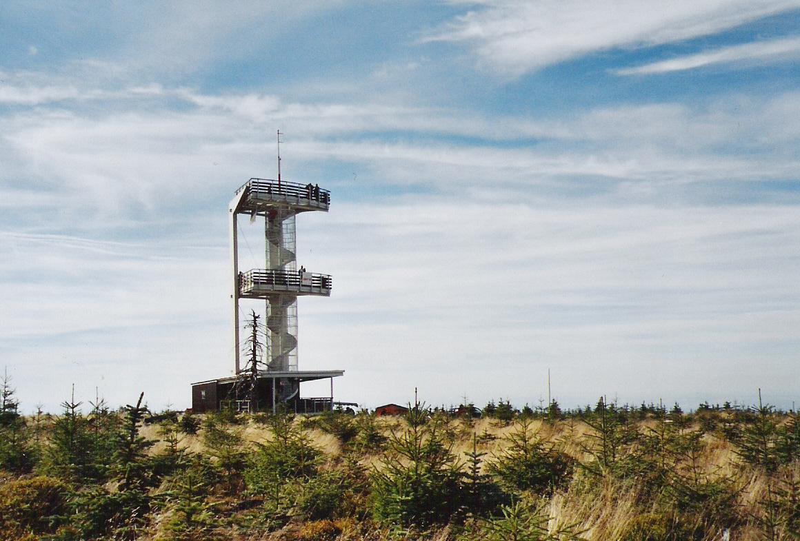
The highest peak is Wysoka Kopa (Hinterberg, 1,127 m, 3,698 feet) near the town of Szklarska Poręba in Poland. Neverteheless, a better-known mountain is Smrk (1124 m, 3,688 feet), with a recently rebuilt look-out tower. Other peaks include Jizera (1,122 m, 3,681 feet) and Stóg Izerski (Heufuder, 1,107 m, 3,632). The peaks in order of elevation:
- Wysoka Kopa (Hinterberg), 1,127 m; highest peak of the Jizera Mountains
- Smrk (Tafelfichte), 1,124 m; highest peak of the Bohemian Jizera Mountains
- Jizera (Siechhübel), 1,122 m
- Stóg Izerski (Heufuder), 1,107 m
- Smědavská hora (Wittigberg), 1,084 m
- Bukovec (Buchberg), 1,005 m; one of the highest basalt peaks in Europe
- Hvězda (Stefanshöhe), 959 m
- Černá Studnice (Schwarzbrunnberg), 869 m
- Tanvaldský Špičák (Tannwalder Spitzberg), 831 m; skiing region near Tanvald
- Oldřichovský Špičák (Buschullersdorfer Spitzberg), 724 m
History

The first settlements in the area date back to prehistory. Later on, Celts, German tribes resides in the valleys until they left in 5th century. Later came Lusatian Sorbs. In the 14th century, German-speaking colonists came and started clearing of the dense primeval forests. Permanent settlements were established. In the 16th century, several glass works were founded. Glassmaking had a profound effect on the ecosystem. The primeval forest was gradually replaced by fast-growing spruce monoculture. Other important industries included tin-mining, metallurgy and textile. The Tabulový kámen (German: Tafelstein), 1072 m) on the northern edge of the Smrk Mountain marked the border between the properties of the Counts of Gallas in Friedland, Bohemia, the von Gersdorff family from Meffersdorf, Upper Lusatia (Unięcice, now part of Wigandsthal) and the Counts of Schaffgotsch from Schreiberhau, Silesia.
In the second half of the 20th century, the ecosystem was badly hit by emissions, produced by lignite fired power stations located in the Zittau basin, part of Europe's ecological Black Triangle. Weakened spruce forest, less resistant against various types of parasites, were on the verge of extinction. The higher parts of the mountains, once densely wooded, became largely treeless, in part also because of excessive deforestation. New roads cut through the once-secluded landscape.
The situation improved only after the fall of communism in 1989. Open-pit coal mines in the former East Germany were closed, as well as several major power plants. Emission filters were installed at the immense Turów Power Station in Bogatynia on the Polish side of Lusatian Neisse. At the same time large-scale reforestation projects were started.
Tourism


The Jizera Mountains are an attractive location for winter sports, cycling and hiking. The centre for both downhill skiing and ski run is Bedřichov. The international cross-country races Jizerská 50 and Bieg Piastów (in Polana Jakuszycka) take place there. Its summer MTB counterpart is also gaining popularity.
The towns surrounding the mountains include Liberec, Frýdlant v Čechách, Nové Město pod Smrkem, Świeradów Zdrój, Szklarska Poręba, Desná, Tanvald and Jablonec nad Nisou.
Protections
Large parts of the Jizera Mountains are under some form of protection. In the smaller Polish parts, the peat bogs in Jizera Valley are part of a relatively small nature protection of about 5 km²; Rezerwat Torfowiska Doliny Izery.[2] In the Czech parts, Jizera Mountains Protected Landscape Area (CHKO Jizerské hory) covers 368 km², or almost all of the Czech parts of the mountains.[3] This landscape protection contains several reserves, including the Jizera Dark Sky Park (Rašeliniště Jizery),[4] dedicated to star watching.
Literature
- (in Czech, German, and English) Weiss, Siegfried (2000) Moje Jizerky - Jizerské hory v proměnách času, Mein Isergebirge - Das Isergebirge im Wandel der Zeit, My Jizera Hills - The Jizera Mountains through a changing of time, Buk
- (in Czech) Nevrlý, Miroslav (1996) Kniha o Jizerských horách, 3rd edition, Civitas
References
- "Ancient and Primeval Beech Forests of the Carpathians and Other Regions of Europe". UNESCO World Heritage Centre. United Nations Educational, Scientific, and Cultural Organization. Retrieved 3 September 2022.
- "Rezerwat TORFOWISKA DOLINY IZERY" (in Polish). Retrieved 15 September 2019.
- "Správa CHKO Jizerské hory" [Administration of the Jizera Mountains Protected Landscape Area] (in Czech). Nature Conservation Agency of the Czech Republic. Retrieved 15 September 2019.
- "Rašeliniště Jizery - Frýdlantsko, Jizerské hory" [Jizera peat bog - Frydlant Region, Jizera Mountains] (in Czech). Retrieved 15 September 2019.
External links
- Photos of Jizera Mountains
- (in Czech) Jizerskehory.cz
- (in German) The Jizera Mountains throughout time
- (in English) The Jizera Mountains 3D Photos gallery

Authority control | |
|---|---|
| General |
|
| National libraries | |
На других языках
[de] Isergebirge
Das Isergebirge (tschechisch: Jizerské hory, polnisch: Góry Izerskie) ist ein Teil der Sudeten und bildet die Verbindung zwischen dem in Deutschland gelegenen Zittauer Gebirge/Lausitzer Gebirge und dem tschechisch/polnischen Riesengebirge. Das Isergebirge liegt sowohl in Tschechien als auch Polen und ist Quellgebiet von Iser (Jizera), Queis (Kwisa) und Lausitzer Neiße (Łužiska Nysa).- [en] Jizera Mountains
[es] Montes Jizera
Las montañas Jizera (en checo, Jizerské hory; en alemán, Isergebirge; en polaco, Góry Izerskie) son parte de los Sudetes en la frontera entre la República Checa y Polonia. En su mayor parte son de granito, con algunas áreas de basalto. Las montañas toman su nombre del río Jizera, que nace en la ladera sur de Smrk.[fr] Monts de la Jizera
Les monts de la Jizera (ou de l’Izera) constituent une chaîne des Sudètes occidentales à la frontière polono-tchèque. Ils sont principalement formés de granite, avec quelques formations de basalte. Ces montagnes tirent leur nom de la Jizera, qui prend sa source au pied de la Smrk.[it] Monti Iser
I Monti Iser (in polacco Góry Izerskie, in ceco Jizerské hory) fanno parte del gruppo montuoso dei Sudeti Occidentali, che sono la porzione occidentale della catena dei Sudeti e costituiscono l'unione tra i monti di Zittau/Monti lusaziani, situati in Germania, e i Monti dei Giganti. I monti Iser sono situati nel territorio della Polonia e della Repubblica Ceca. Vi si trovano le sorgenti dei fiumi Iser, Queis e del Neiße.[ru] Йизерские горы
Йизерские горы, И́зерские горы (чеш. Jizerské hory; польск. Góry Izerskie; нем. Isergebirge) — горный хребет на границе Чехии и Польши, в системе Западных Судет.Другой контент может иметь иную лицензию. Перед использованием материалов сайта WikiSort.org внимательно изучите правила лицензирования конкретных элементов наполнения сайта.
WikiSort.org - проект по пересортировке и дополнению контента Википедии