geo.wikisort.org - Mountains
The České středohoří, also known as Central Bohemian Uplands[1] or Central Bohemian Highlands,[2] is a geomorphological region in northern Bohemia of the Czech Republic.
| Central Bohemian Uplands | |
|---|---|
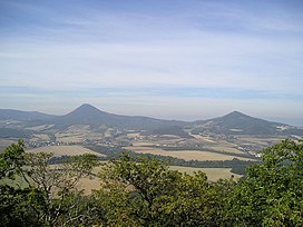
 Milešovka (left) and Kletečná as seen from Lovoš | |
| Highest point | |
| Peak | Milešovka |
| Elevation | 837 m (2,746 ft) |
| Coordinates | 50°35′00″N 14°07′30″E |
| Dimensions | |
| Area | 1,266 km2 (489 sq mi) |
| Naming | |
| Native name | České středohoří (Czech) |
| Geography | |
 Location of the České Středohoří in the Czech Republic | |
| Country | Czech Republic |
| Regions | Ústí nad Labem and Liberec |
| Range coordinates | 50°35′00″N 14°07′30″E |
| Parent range | Ore Mountains Foothills |
| Geology | |
| Type of rock | basalt |
Geography
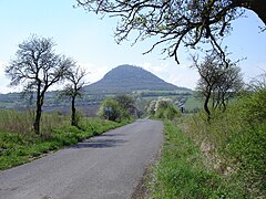
The region is about 80 km long, extending from Česká Lípa in the northeast to Louny in the southwest and from Litoměřice in the south to Děčín in the north, and is intersected by the river Elbe. The mountains, which are of volcanic origin, have distinctively sharp solitary peaks.
Protection
The eponymous protected landscape area covers most of the uplands' territory; consequently, construction through the area of the D8 motorway (part of European route E55 between Dresden and Prague) was very controversial. Despite this, the motorway was finally completed in December 2016.
Gallery
|
See also
References
- The Central Bohemian Uplands and Žatecko at www.czecot.com. Accessed on 28 Feb 2011.
- e.g. The New Encyclopaedia Britannica, Volume 31, Encyclopaedia Britannica, 1998, p. 371
External links
Wikivoyage has a travel guide for Central Bohemian Uplands.
На других языках
[de] Böhmisches Mittelgebirge
Das Böhmische Mittelgebirge (tschechisch České středohoří) ist ein Mittelgebirge in Tschechien und Teil des Böhmischen Beckens. Es befindet sich in Nordböhmen zu beiden Seiten der Elbe. Es erstreckt sich dabei in einer Länge von 80 km zwischen dem Nordböhmischen Becken im Westen und dem Lausitzer Gebirge (Lužické hory) im Osten. Im Norden geht es fast nahtlos in die Berglandschaft der Böhmischen Schweiz über. Im Süden befinden sich die weiträumigen Niederungen von Eger und Elbe. Das Böhmische Mittelgebirge steht seit 1976 als ChKO České středohoří unter Landschaftsschutz.- [en] České Středohoří
[fr] České Středohoří
České Středohoří, ou hauts-plateaux de Bohême centrale[1], est une chaîne de montagnes du nord de la Bohême, en Tchéquie. Longue d'environ 80 km, elle s'étend de Česká Lípa au nord-est à Bílina au sud-ouest, et de Litoměřice au nord à Děčín au sud ; elle est traversée par l'Elbe.[it] Monti della Boemia centrale
I Monti della Boemia centrale (in ceco České Středohoří) sono un massiccio montuoso della Repubblica Ceca settentrionale, lungo circa 90 km e attraversato dal fiume Elba. I monti sono formati da basalto e occupano una superficie di circa 1266 km².Текст в блоке "Читать" взят с сайта "Википедия" и доступен по лицензии Creative Commons Attribution-ShareAlike; в отдельных случаях могут действовать дополнительные условия.
Другой контент может иметь иную лицензию. Перед использованием материалов сайта WikiSort.org внимательно изучите правила лицензирования конкретных элементов наполнения сайта.
Другой контент может иметь иную лицензию. Перед использованием материалов сайта WikiSort.org внимательно изучите правила лицензирования конкретных элементов наполнения сайта.
2019-2025
WikiSort.org - проект по пересортировке и дополнению контента Википедии
WikiSort.org - проект по пересортировке и дополнению контента Википедии


