geo.wikisort.org - Mountains
The Chilean Coastal Range (Spanish: Cordillera de la Costa) is a mountain range that runs from north to south along the Pacific coast of South America parallel to the Andean Mountains, extending from Morro de Arica in the north to Taitao Peninsula, where it ends at the Chile Triple Junction, in the south. The range has a strong influence on the climate of Chile since it produces a rain shadow to the east. Because of this the vegetation growing on the seaward slopes is much more exuberant than in the interior. Compared to the coastal lowlands and the Intermediate Depression, it is sparsely populated with land use varying from protected areas to grazing and silviculture. The range is present in all Chilean regions, except for Coquimbo Region and Magallanes Region.
This article needs additional citations for verification. (October 2014) |
| Chilean Coastal Range | |
|---|---|
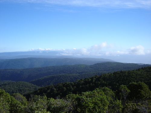 View from Cerro Oncol | |
| Highest point | |
| Peak | Cerro Vicuña Mackenna |
| Elevation | 3,114 m (10,217 ft)[1] |
| Coordinates | 24°27′01″S 70°02′55″W[1] |
| Dimensions | |
| Length | 3,100 km (1,900 mi) North-South |
| Geography | |
 The eastern border of the Chilean Coast Range is marked with yellow. Uncertain borders are marked with dots.
| |
| Country | Chile |
| Range coordinates | 32°58′32″S 71°00′49″W |
| Parent range | Andes |
Geography
Like the Andes, the coastal range becomes progressively lower with increasing latitude. The range begins at Morro de Arica in the north and reaches its highest point, of 3114 m, in Sierra Vicuña Mackenna in the Antofagasta Region. Between Copiapó and Aconcagua rivers, in the so-called Norte Chico region, the range fuses with the Andes. Just north of Santiago the range separates from the Andes but comes close to it again near Paine, a southern suburb of Santiago, and San Fernando. From Santiago south the range loses height until reaching the Bío-Bío River, beyond which the Nahuelbuta range emerges which reaches about 1500 m in its central parts. South of Nahuelbuta Range, in the Araucanía Region, the coastal range is replaced by a flatland area. South of Toltén River the range rises again as the Cordillera de Mahuidanchi. Beyond the heights of Corral this range changes into Cordillera Pelada. From Chacao Channel south the range is penetrated by the sea creating islands and peninsulas. Chiloé Island, the largest of these, has two ranges: Cordillera del Piuchén from Chacao Channel to Cucao Lake and Pirulil Range in the southern half. South of Chiloé the portions of the range above sea level form the Guaitecas and the Chonos Archipelagos. The southern extreme of the range forms the Taitao Peninsula and its sub-peninsula Tres Montes.
The range can be divided in several minor ranges. Some of these ranges and their boundaries are:

- Sierra Vicuña Mackenna (24–25° S)
- Vizcachas Mountains (33° S)
- Cordillera de Nahuelbuta (37–38° S)
- Imperial-Toltén River lowland
- Cordillera de Queule (39°)
- Cordillera de Mitropulli (39°)
- Loncoche Massif
- Cordillera de Oncol (39° S)
- Altos de Valdivia (40° S)
- Cordillera Pelada (40° S)
- Cordillera El Sarao (41° S)
- Cordillera del Piuchén (42° S)
- Pirulil Range (42–43° S)
Geology
The range has no single structural or lithological origin but is the result of the alignment of horst, forearc highs and upthrusted blocks along Chile's coast. The range was separated from the Andes during the Tertiary rise of the Andes due to the subsidence of the Intermediate Depression.
The range is made of different lithological units. From Valparaíso Region to Lanalhue Fault the bedrock is largely made up of the Coastal Batholith of central Chile. These igneous rocks were once part of a proto-Andean magmatic belt. South of Lanalhue Fault most of the range is made up by the Bahía Mansa Metamorphic Complex which is made up of medium grade metamorphic rocks including schists. The analogous granites of the northern part of the coast range are placed inside the Andes in this latitudes.
During the Miocene regions of the Chilean Coast Range hosted several volcanoes. At present it does not show any sign of volcanic activity.
The northern part of the Chilean Coast Range contains a series of iron ore deposits known as the Chilean Iron Belt which are aligned along the Atacama Fault.[2]
See also
- Climate of Chile
- Geology of Chile
- Chilean Central Valley
- Atacama Desert
References
- Síntesis geográfica nacional, Chilean government.
- "Cerro Vicuña Mackenna". Wikimapia.
- Tornos, Fernando; Hanchar, John M.; Munizaga, Rodrigo; Velasco, Francisco; Galindo, Carmen (2020). "The role of the subducting slab and melt crystallization in the formation of magnetite-(apatite) systems, Coastal Cordillera of Chile". Mineralium Deposita. 56 (2): 253–278. doi:10.1007/s00126-020-00959-9. S2CID 212629723.
External links
 Media related to Cordillera de la Costa (Chile) at Wikimedia Commons
На других языках
[de] Cordillera de la Costa (Chile)
Cordillera de la Costa ist das Küstengebirge in Chile.- [en] Chilean Coast Range
[fr] Cordillère de la Côte (Andes centrales)
La cordillère de la Côte est une série de chaînes de montagnes d'Amérique du Sud orientées nord-sud et qui s'étend sur plusieurs milliers de kilomètres le long de l'océan Pacifique, sur la frange occidentale des Andes, du cerro Tunga au Pérou jusqu'à la région Aisén del General Carlos Ibáñez del Campo au Chili. Les plus hauts sommets sont dans la partie nord avec le cerro Vicuña Mackenna culminant à 3 114 mètres d'altitude. La chaîne s'abaisse progressivement vers le sud pour disparaître au niveau de la péninsule de Taitao. Elle joue un rôle important dans la sécheresse du désert de l'Atacama, le plus sec du monde, en interceptant l'air humide venu de l'océan Pacifique (phénomène d'ombre pluviométrique).[it] Cordigliera della Costa (Cile)
La Cordigliera della Costa (in spagnolo Cordillera de la Costa) è una catena montuosa del Cile.[ru] Береговая Кордильера
Берегова́я Кордилье́ра[1], или Береговы́е Кордилье́ры Анд[2], Береговые Кордильеры[3] (исп. Cordillera de la Costa) — меридиональный хребет, протянувшийся почти параллельно Главной Кордильере и отделяющий Продольную долину Чили от Тихого океана.Другой контент может иметь иную лицензию. Перед использованием материалов сайта WikiSort.org внимательно изучите правила лицензирования конкретных элементов наполнения сайта.
WikiSort.org - проект по пересортировке и дополнению контента Википедии