geo.wikisort.org - Coast
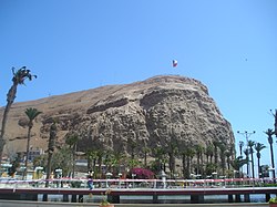
Morro de Arica is a steep hill located in the Chilean city of Arica. Its height is 139 metres above sea level. It was the last bulwark of defense for the Peruvian troops who garrisoned the city during the War of the Pacific (1879–1883). Morro de Arica was assaulted and captured on June 7, 1880, by Chilean troops in the last part of the Tacna and Arica campaign.[1] Morro de Arica rises steeply from the city and the sea, with a more gentle slope towards the east. A giant flag of Chile is flown on its summit. Morro de Arica was declared a national monument on October 6, 1971.[2]
| Wikimedia Commons has media related to Morro de Arica. |

References
- Pinochet Ugarte, Augusto; Villaroel Carmona, Rafael; Lepe Orellana, Jaime; Fuente-Alba Poblete, J. Miguel; Fuenzalida Helms, Eduardo (1997) [1984]. Historia militar de Chile (in Spanish). Vol. II (3rd ed.). Biblioteca Militar. pp. 165–166.
- "Morro de Arica". Consejo de Monumentos Nacionales de Chile (in Spanish). Retrieved 5 March 2020.
На других языках
- [en] Morro de Arica
[es] Morro de Arica
El morro de Arica es un cerro costero, que tiene unos 100 metros de altura, emplazado al sur del espacio urbano de Arica, en la región de Arica y Parinacota, en el norte de Chile. Es el mayor referente turístico y simbólico de la ciudad. Fue declarado Monumento Nacional el 6 de octubre de 1971.[1]Текст в блоке "Читать" взят с сайта "Википедия" и доступен по лицензии Creative Commons Attribution-ShareAlike; в отдельных случаях могут действовать дополнительные условия.
Другой контент может иметь иную лицензию. Перед использованием материалов сайта WikiSort.org внимательно изучите правила лицензирования конкретных элементов наполнения сайта.
Другой контент может иметь иную лицензию. Перед использованием материалов сайта WikiSort.org внимательно изучите правила лицензирования конкретных элементов наполнения сайта.
2019-2025
WikiSort.org - проект по пересортировке и дополнению контента Википедии
WikiSort.org - проект по пересортировке и дополнению контента Википедии