geo.wikisort.org - Island
The Sunda Arc is a volcanic arc that produced the volcanoes that form the topographic spine of the islands of Sumatra, Nusa Tenggara, and Java, the Sunda Strait and the Lesser Sunda Islands. The Sunda Arc begins at Sumatra and ends at Flores, and is adjacent to the Banda Arc.[1] The Sunda Arc is formed via the subduction of the Indo-Australian Plate beneath the Sunda and Burma plates at a velocity of 63–70 mm/year.[2]

| Geography | |
|---|---|
| Location | Indonesia |
| Coordinates | 7.1510° S, 110.1403° E |
| Major islands | Sumatra, Java, Nusa Tenggara |
| Additional information | |
| Tectonic - Indo-Australian Plate and Eurasia Plate
Major Volcanoes - Merapi, Krakatoa, Mount Sinabung, Semeru | |
Formation and geologic setting
Mid-oceanic ridge basalts (MORB) form most of the oceanic basin south of Sunda, according to geodynamic studies.[3] These plates began to converge in the Early Miocene.[3] The Indo-Australian Plate is subducting beneath the Eurasian Plate with the dip angle of 49-56 degrees.[4] The slab subducting under Java is continuous down to the lower mantle. However, the slab appears to beak apart under Sumatra Island.[5][6] Earthquake depth records indicate that there is no deep seismic activity in Sumatra, likely due to the age of the subducting complex..[7][6][8] Two types of subductions have been identified along the Sunda Arc: 1) orthogonal subduction along Java and 2) oblique subduction on the Sumatra side. These subductions are separated by the Sunda Strait.[9]
Notable seismic events
With the ongoing magmatic activities and the nature of the subduction zone, Sunda Arc experiences major seismic events throughout history. These events cost the loss of lives and vast destruction along the coast. These are some major seismic events that have been recorded.
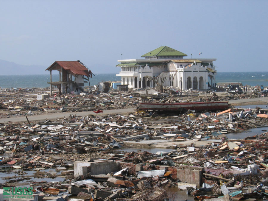
Tsunami on December 2004, Indian Ocean
In 2004, the tsunami in Indian Ocean was triggered by an earthquake of 9.15 magnitude near Sumatra Island.[10] In Banda Aceh area, the tsunami height reached up to 35 meters, which surpassed value recorded prior to this event.[11]
Tsunami on July 2006, West Java and Central Java, Indonesia
A devastating event occurred on July 17, 2006, with major destruction along West Java and Central Java. The Mw-7.7 earthquake-induced tsunami struck over 250 km of the coastline and cost more than 600 deaths. The approximate run-up height was about 4–6 meters.[12]
Historic eruptions and arc volcanism
The Sunda Arc is home to some of the world's most dangerous and explosive volcanoes.[13] The 1815 eruption of Mount Tambora on Sumbawa and the 1257 eruption of Mount Samalas on Lombok were among the largest in the last two millennia, ranking 7 on the VEI scale.[14] The Sunda Arc subduction zone was also the site of one of the largest known eruptions of the Cenozoic, the VEI 8 Toba supereruption on Sumatra, which expelled 2,800 km³ of magma c. 74,000 BP.[15] The resulting caldera has become Lake Toba. The loudest noise in recorded history occurred during the 1883 eruption of Krakatoa and was heard 5,000 km (3,100 mi) away.[16] Hundreds of thousands of people have been killed by these eruptions and by episodes of activity at other volcanoes, including Papandayan, Galunggung, Merapi, Kelud, Sinabung and Agung.
Main-arc volcanism

The main-arc volcanism along Sunda is mainly derived from the interaction between the Indo-Australian Plate and the Eurasia Plate. Magma originates from partial melting of the mantle wedge driven by the fluids from subducting slab.[17] In addition, volcanic rocks from Quaternary generally show more enrichment in alkaline contents than those from Tertiary age.[17][13] The majority of basalts of the arc have calc-alkaline contents, except for some potassic lava production in East Java.[18]
Back-arc volcanism
The magmatic activities along the back-arc may or may not relate to the main-arc materials. Magma and lava appear to have originated from molten materials at a deeper part of the mantle as supported by a higher K2O/Na2O ratio in comparison to other part of Sunda Arc.[3][17] Most salient volcanoes in back-arc region are Lasem, Muria, and Bawean in which their volcanic rocks show complex patterns in terms of chemical signature.[3]

Major islands
Java
Java Island is located on the east side of Sunda Arc, residing between Sumatra and Bali.[19] Its oceanic crust's thickness is approximately 20-25 kilometers.[17] With the geological activities and the tectonic nature of Sunda Arc, megathrust earthquakes and volcanic activities are ubiquitous at Java island.[20] Modern volcanoes at Java are formed during Tertiary with typical products of andesitic composition and progressively get more alkali content during Quaternary.[17][21] Along the Java island, there are approximately 62 geothermal fields which can be utilized for further usages including producing electricity.[22] Java is also a germinal center for supplying gold and cooper in which the occurrences of these low-sulfidication (LS) epithermal deposits may associate with magmatic arc activities[19] with the spatial relationship between the akaditic magma and porphyry Cu-Au deposits.[23][24]
East Java
Most volcanic activity in East Java is Plinian-type, which is very explosive and emits columns of hot volcanic debris.[25] The adiakitic magma, which deviates from usual island-arc magma, is associated with porphyry deposits.[23] There is evidence that the Ringgit-Beser volcanic complex also produces potassic and magnesian lava, which could be a result of the decreasing influence of subduction-related material.[26] A major volcano in East Java is Mount Bromo.
Central Java
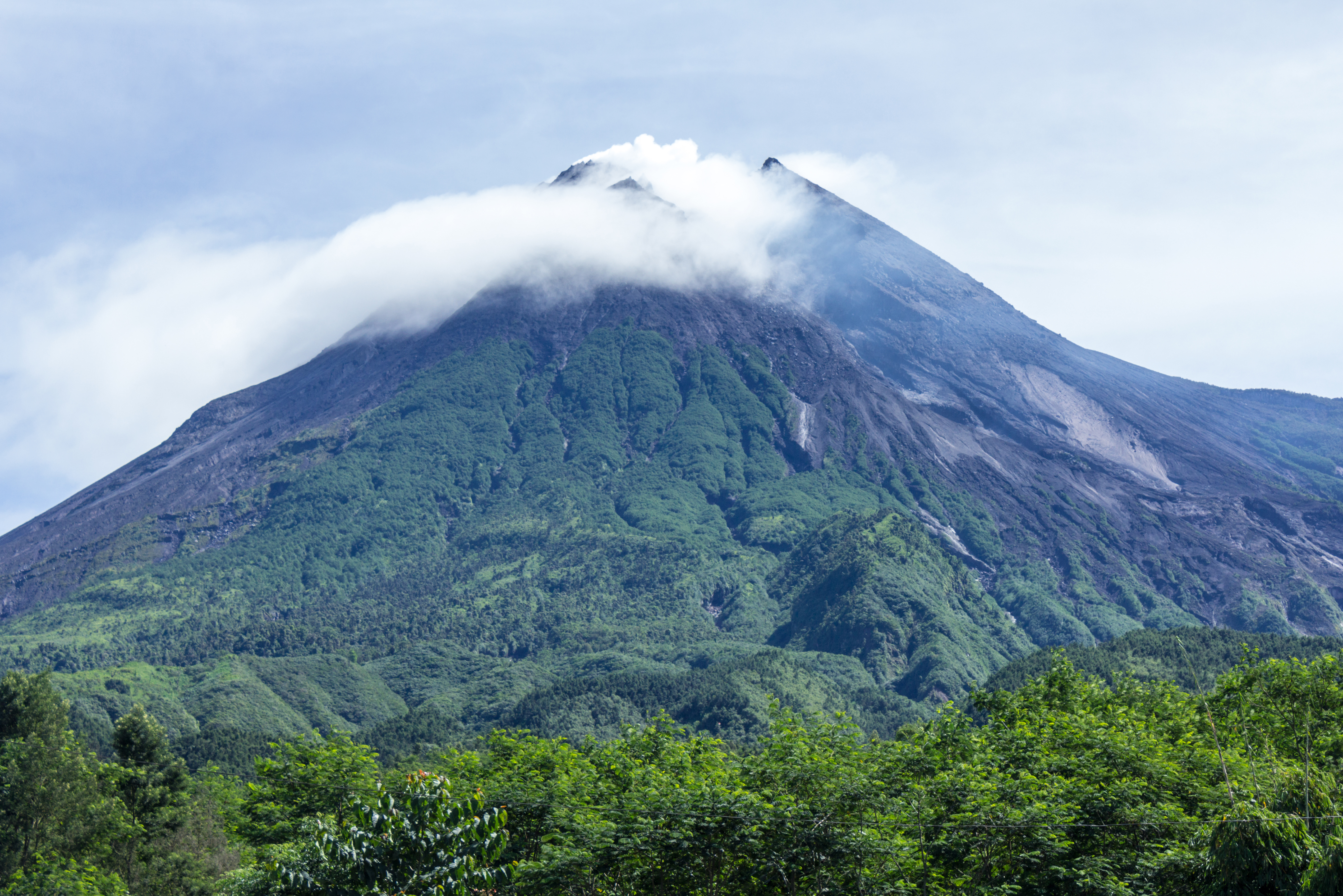
There exist two main arcs at Central Java which are Southern Mountain Arc (SMA) and Modern Volcanic Arc (MVA) which give rise to frequent volcanic activities.[20] Prior studies suggested that SMA is formed during Middle Eocene,[27] followed by the subduction that resulted in the formation of MVA in Late Eocene.[28][20] Central Java is home to one of the most notorious volcanoes, Merapi, as well as other major volcanoes such as Merbabu, Muria, and Slamet.
Mount Merapi is the most active volcano in Indonesia which erupt periodically every 2–6 years[29] and has shown perennial volcanic activities dated back roughly 2000 years ago based on carbon isotropic signatures.[30] The earliest eruption has been approximated to be roughly 40,000 years ago.[31] The most recent significant eruptions occurred in 1994, 2006, and 2010. Mount Merapi is a steep stratovocano situated on Central Java Island with its seismic and volcanic activities that could pose major threats to countless lives and infrastructures in its vicinity.[32] Most recent volcanic activities are induced by the collapse of lava dome, contributing to highly explosive eruption of andesitic materials.[32][33]
West Java
The volcanic activities in this region have began roughly since Pliocene or Pleistocene epoch.[34][35] There are two major volcanic zones called the volcanic front (VF) and the rear arc (RA) with different chemical imprints.[36] The geochemical study of major and trace elements and isotopic signatures of lava have confirmed the steady-state subduction and ongoing replenishment of magma for about 10 Ma.[36] The volcanic rocks founded on West Java are dated back to the Eocene.[36] The basement of West Java is continental lithosphere which can be inferred from crustal assimilation and contamination in volcanic rocks.[37][38]
Krakatoa
The island of Anak Krakatau has grown at an average rate of five inches (13 cm) per week since the 1950s.[39] Quiet periods of a few days have alternated with almost continuous Strombolian eruptions since 1994. In 1883 CE, tsunami were triggered by the eruption of Krakatoa with the run-up of 41 meters.[40] The magnitude of damage reached Panama, which was located almost 19,300 km away from the focus.[40]

Sumatra
Sumatra island is located on the southwest side of Sunda Arc.[41] The main seismic zone of Sumatra is the Sumatra Fault System (SFS), which trends NW-SE.[41] The subducting oceanic crust are dated to be approximately 50 to 90 Ma.[6] A K/Ar study reveals that subducted-related magmatism in Sumatra started roughly in early Mesozoic according to the evidences derived from the plutonic body on Barisan Mountain.[42][41][43] The key mineralization found on Sumatra are epithermal veins of Au, Ag, Zn, Pb, and other metals in which these ore bodies are correlated to arc volcanism and subvolcanism intrusive bodies.[44]
Mount Sinabung is a stratovolcano of andesite and dacite in the Karo plateau of North Sumatra, 40 kilometres (25 mi) from the Lake Toba supervolcano. It has been continuously active since 2013.
Nusa Tenggara
Nusa Tenggara lies at the east side of Sunda. The information and study on this island are scarce compared to Java due to the difficulty of access.[1] Generally, the island is composed on Quaternary volcanic deposits.[1] Major volcanoes in Nusa Tenggara are Kelimutu and Mount Rinjani. Seismic studies have shown clusters of seismic events beneath active island-arc volcanoes, which may be a result from the collision zone.[45][46]
See also
References
- Pacey, Adam; Macpherson, Colin G.; McCaffrey, Ken J. W. (2013-05-01). "Linear volcanic segments in the central Sunda Arc, Indonesia, identified using Hough Transform analysis: Implications for arc lithosphere control upon volcano distribution". Earth and Planetary Science Letters. 369–370: 24–33. Bibcode:2013E&PSL.369...24P. doi:10.1016/j.epsl.2013.02.040. ISSN 0012-821X.
- Simons, W. J. F.; Socquet, A.; Vigny, C.; Ambrosius, B. a. C.; Abu, S. Haji; Promthong, Chaiwat; Subarya, C.; Sarsito, D. A.; Matheussen, S.; Morgan, P.; Spakman, W. (2007). "A decade of GPS in Southeast Asia: Resolving Sundaland motion and boundaries". Journal of Geophysical Research: Solid Earth. 112 (B6): B06420. Bibcode:2007JGRB..112.6420S. doi:10.1029/2005JB003868. ISSN 2156-2202.
- Hall, Robert (2002-04-01). "Cenozoic geological and plate tectonic evolution of SE Asia and the SW Pacific: computer-based reconstructions, model and animations". Journal of Asian Earth Sciences. Cenozoic geological and plate tectonic evolution of SE Asia and the SW Pacific: Computer-based reconstructions, model and animations (including CD-ROM). 20 (4): 353–431. Bibcode:2002JAESc..20..353H. doi:10.1016/S1367-9120(01)00069-4. ISSN 1367-9120.
- Syracuse, Ellen M.; Abers, Geoffrey A. (2006-05-23). "Global compilation of variations in slab depth beneath arc volcanoes and implications: ARC VOLCANO SLAB DEPTH". Geochemistry, Geophysics, Geosystems. 7 (5): n/a. doi:10.1029/2005GC001045. S2CID 134426211.
- Pesicek, J. D.; Thurber, C. H.; Widiyantoro, S.; Engdahl, E. R.; DeShon, H. R. (2008). "Complex slab subduction beneath northern Sumatra". Geophysical Research Letters. 35 (20): L20303. Bibcode:2008GeoRL..3520303P. doi:10.1029/2008GL035262. ISSN 1944-8007. S2CID 129435818.
- Widiyantoro, S.; van der Hilst, R. (1996-03-15). "Structure and Evolution of Lithospheric Slab Beneath the Sunda Arc, Indonesia". Science. 271 (5255): 1566–1570. Bibcode:1996Sci...271.1566W. doi:10.1126/science.271.5255.1566. ISSN 0036-8075. S2CID 128483384.
- Wortel, M. J. R.; Vlaar, N. J. (1988). "Subduction zone seismicity and the thermo-mechanical evolution of downgoing lithosphere". Pure and Applied Geophysics. 128 (3–4): 625–659. Bibcode:1988PApGe.128..625W. doi:10.1007/BF00874551. ISSN 0033-4553. S2CID 55287111.
- Kirby, S.H; Stein, S.; Okal, EA; Rubie, D. (1996). "Deep earthquakes and metastable mantle phase transformations in subducting oceanic lithosphere". Rev. Geophys. Space Phys. 34. doi:10.1029/96RG01050.
- Kopp, Heidrun; Flueh, Ernst R.; Klaeschen, Dirk; Bialas, Jörg; Reichert, Christian (2001-11-01). "Crustal structure of the central Sunda margin at the onset of oblique subduction". Geophysical Journal International. 147 (2): 449–474. Bibcode:2001GeoJI.147..449K. doi:10.1046/j.0956-540x.2001.01547.x. ISSN 0956-540X. S2CID 130459678.
- Meltzner, Aron J.; Sieh, Kerry; Abrams, Michael; Agnew, Duncan C.; Hudnut, Kenneth W.; Avouac, Jean-Philippe; Natawidjaja, Danny H. (2006-02-15). "Uplift and subsidence associated with the great Aceh-Andaman earthquake of 2004: THE 2004 EARTHQUAKE". Journal of Geophysical Research: Solid Earth. 111 (B2): n/a. doi:10.1029/2005JB003891.
- Lavigne, F.; Gomez, C.; Giffo, M.; Wassmer, P.; Hoebreck, C.; Mardiatno, D.; Prioyono, J.; Paris, R. (2007-02-09). "Field observations of the 17 July 2006 Tsunami in Java". Natural Hazards and Earth System Sciences. 7 (1): 177–183. Bibcode:2007NHESS...7..177L. doi:10.5194/nhess-7-177-2007. ISSN 1684-9981.
- Mori, Jim; Mooney, Walter D.; Kurniawan, Sandy Arief; Anaya, Aan; Widiyantoro, Sri (2007). "The 17 July 2006 Tsunami Earthquake in West Java, Indonesia". Seismological Research Letters. 78 (2): 201–207. doi:10.1785/gssrl.78.2.201.
- Deegan, Frances M.; Whitehouse, Martin J.; Troll, Valentin R.; Geiger, Harri; Jeon, Heejin; le Roux, Petrus; Harris, Chris; van Helden, Marcel; González-Maurel, Osvaldo (2021-06-24). "Sunda arc mantle source δ18O value revealed by intracrystal isotope analysis". Nature Communications. 12 (1): 3930. Bibcode:2021NatCo..12.3930D. doi:10.1038/s41467-021-24143-3. ISSN 2041-1723. PMC 8225799. PMID 34168147.
- Oppenheimer, Clive (2016-08-19). "Climatic, environmental and human consequences of the largest known historic eruption: Tambora volcano (Indonesia) 1815". Progress in Physical Geography. 27 (2): 230–259. doi:10.1191/0309133303pp379ra. S2CID 131663534.
- Ninkovich, D.; Shackleton, N. J.; Abdel-Monem, A. A.; Obradovich, J. D.; Izett, G. (1978-12-07). "K–Ar age of the late Pleistocene eruption of Toba, north Sumatra". Nature. 276 (5688): 574–577. Bibcode:1978Natur.276..574N. doi:10.1038/276574a0. ISSN 1476-4687. S2CID 4364788.
- Winchester, Simon. (2003). Krakatoa : the day the world exploded, 27 August 1883. London: Viking. ISBN 0-670-91126-7. OCLC 52531741.
- Setijadji, Lucas Donny; Kajino, Shigeo; Imai, Akira; Watanabe, Koichiro (2006). "Cenozoic Island Arc Magmatism in Java Island (Sunda Arc, Indonesia): Clues on Relationships between Geodynamics of Volcanic Centers and Ore Mineralization". Resource Geology. 56 (3): 267–292. doi:10.1111/j.1751-3928.2006.tb00284.x. ISSN 1751-3928. S2CID 128418609.
- Carn, S. A.; Pyle, D. M. (2001-09-01). "Petrology and Geochemistry of the Lamongan Volcanic Field, East Java, Indonesia: Primitive Sunda Arc Magmas in an Extensional Tectonic Setting?". Journal of Petrology. 42 (9): 1643–1683. Bibcode:2001JPet...42.1643C. doi:10.1093/petrology/42.9.1643. ISSN 0022-3530.
- Prihatmoko, Sukmandaru; Idrus, Arifudin (2020-06-01). "Low-sulfidation epithermal gold deposits in Java, Indonesia: Characteristics and linkage to the volcano-tectonic setting". Ore Geology Reviews. 121: 103490. doi:10.1016/j.oregeorev.2020.103490. ISSN 0169-1368. S2CID 216374772.
- Suhardja, S. K.; Widiyantoro, S.; Métaxian, J. -P.; Rawlinson, N.; Ramdhan, M.; Budi-Santoso, Agus (2020-05-01). "Crustal thickness beneath Mt. Merapi and Mt. Merbabu, Central Java, Indonesia, inferred from receiver function analysis". Physics of the Earth and Planetary Interiors. 302: 106455. Bibcode:2020PEPI..30206455S. doi:10.1016/j.pepi.2020.106455. ISSN 0031-9201. S2CID 216177998.
- Whitford, D. J (1975-09-01). "Strontium isotopic studies of the volcanic rocks of the Saunda arc, Indonesia, and their petrogenetic implications". Geochimica et Cosmochimica Acta. 39 (9): 1287–1302. Bibcode:1975GeCoA..39.1287W. doi:10.1016/0016-7037(75)90136-2. ISSN 0016-7037.
- Purnomo, Budi Joko; Pichler, Thomas (2014-09-15). "Geothermal systems on the island of Java, Indonesia". Journal of Volcanology and Geothermal Research. 285: 47–59. Bibcode:2014JVGR..285...47P. doi:10.1016/j.jvolgeores.2014.08.004. ISSN 0377-0273.
- Oyarzun, Roberto; Márquez, Alvaro; Lillo, Javier; López, Ivan; Rivera, Sergio (2014-03-01). "Giant versus small porphyry copper deposits of Cenozoic age in northern Chile: adakitic versus normal calc-alkaline magmatism". Mineralium Deposita. 36 (8): 794–798. doi:10.1007/s001260100205. ISSN 0026-4598. S2CID 129497628.
- Imai, Akira (2008-11-05). "Metallogenesis of Porphyry Cu Deposits of the Western Luzon Arc, Philippines: K-Ar ages, SO 3 Contents of Microphenocrystic Apatite and Significance of Intrusive Rocks". Resource Geology. 52 (2): 147–161. doi:10.1111/j.1751-3928.2002.tb00127.x. S2CID 128948223.
- Smyth, H.; Hall, R.; Hamilton, Joseph; Kinny, Peter (2005). "East Java: Cenozoic basins, volcanoes and ancient basement". Proceedings of the Indonesian Petroleum Association, 30th Annual Convention. hdl:20.500.11937/21075. ISSN 0126-1126.
- Edwards, C. M. H.; Menzies, M. A.; Thirlwall, M. F.; Morris, J. D.; Leeman, W. P.; Harmon, R. S. (1994-12-01). "The Transition to Potassic Alkaline Volcanism in Island Arcs: The Ringgit--Beser Complex, East Java, Indonesia". Journal of Petrology. 35 (6): 1557–1595. Bibcode:1994JPet...35.1557E. doi:10.1093/petrology/35.6.1557. ISSN 0022-3530.
- Smyth, Helen R.; Hall, Robert; Nichols, Gary J. (2008), "Cenozoic volcanic arc history of East Java, Indonesia: The stratigraphic record of eruptions on an active continental margin", Special Paper 436: Formation and Applications of the Sedimentary Record in Arc Collision Zones, Geological Society of America, pp. 199–222, doi:10.1130/2008.2436(10), ISBN 978-0-8137-2436-2, retrieved 2020-09-22
- Clements, Benjamin; Hall, Robert; Smyth, Helen R.; Cottam, Michael A. (2009-05-01). "Thrusting of a volcanic arc: a new structural model for Java". Petroleum Geoscience. 15 (2): 159–174. doi:10.1144/1354-079309-831. ISSN 1354-0793. S2CID 140597900.
- Ratdomopurbo, A; Poupinet, G (2000). "An overview of the seismicity of Merapi volcano (Java, Indonesia), 1983–1994". Journal of Volcanology and Geothermal Research. 100 (1–4): 193–214. Bibcode:2000JVGR..100..193R. doi:10.1016/S0377-0273(00)00137-2.
- Gertisser, Ralf; Keller, Jörg (2003). "Temporal variations in magma composition at Merapi Volcano (Central Java, Indonesia): magmatic cycles during the past 2000 years of explosive activity". Journal of Volcanology and Geothermal Research. 123 (1–2): 1–23. Bibcode:2003JVGR..123....1G. doi:10.1016/S0377-0273(03)00025-8.
- Camus, G; Gourgaud, A; Mossand-Berthommier, P. -C; Vincent, P. -M (2000-07-01). "Merapi (Central Java, Indonesia): An outline of the structural and magmatological evolution, with a special emphasis to the major pyroclastic events". Journal of Volcanology and Geothermal Research. 100 (1): 139–163. Bibcode:2000JVGR..100..139C. doi:10.1016/S0377-0273(00)00135-9. ISSN 0377-0273.
- Luehr, Birger-G.; Koulakov, Ivan; Rabbel, Wolfgang; Zschau, Jochen; Ratdomopurbo, Antonius; Brotopuspito, Kirbani Sri; Fauzi, Pak; Sahara, David P. (2013-07-01). "Fluid ascent and magma storage beneath Gunung Merapi revealed by multi-scale seismic imaging". Journal of Volcanology and Geothermal Research. Merapi eruption. 261: 7–19. Bibcode:2013JVGR..261....7L. doi:10.1016/j.jvolgeores.2013.03.015. ISSN 0377-0273.
- Newhall, C. G.; Bronto, S.; Alloway, B.; Banks, N. G.; Bahar, I.; del Marmol, M. A.; Hadisantono, R. D.; Holcomb, R. T.; McGeehin, J.; Miksic, J. N.; Rubin, M. (2000-07-01). "10,000Years of explosive eruptions of Merapi Volcano, Central Java: archaeological and modern implications". Journal of Volcanology and Geothermal Research. 100 (1): 9–50. Bibcode:2000JVGR..100....9N. doi:10.1016/S0377-0273(00)00132-3. ISSN 0377-0273.
- Sriwana, T.; van Bergen, M.J.; Varekamp, J.C.; Sumarti, S.; Takano, B.; van Os, B.J.H.; Leng, M.J. (2000). "Geochemistry of the acid Kawah Putih lake, Patuha Volcano, West Java, Indonesia". Journal of Volcanology and Geothermal Research. 97 (1–4): 77–104. Bibcode:2000JVGR...97...77S. doi:10.1016/S0377-0273(99)00178-X.
- Soeria-Atmadja, R.; Maury, R. C.; Bellon, H.; Pringgoprawiro, H.; Polve, M.; Priadi, B. (1994-01-01). "Tertiary magmatic belts in Java". Journal of Southeast Asian Earth Sciences. Symposium on the Dynamics of Subduction and its Products. 9 (1): 13–27. Bibcode:1994JAESc...9...13S. doi:10.1016/0743-9547(94)90062-0. ISSN 0743-9547.
- Sendjaja, Yoga A.; Kimura, Jun-Ichi (2010). "Geochemical variation in Tertiary-Quaternary lavas of the West Java arc, Indonesia: Steady-state subduction over the past 10 million years". Journal of Mineralogical and Petrological Sciences. 105 (1): 20–28. Bibcode:2010JMPeS.105...20S. doi:10.2465/jmps.080930. ISSN 1345-6296. S2CID 129705669.
- Mirzam Abdurrachman (2012). "Geochemical variation of Quaternary volcanic rocks in Papandayan area, West Java, Indonesia: A role of crustal component". doi:10.13140/RG.2.1.4473.7048.
{{cite journal}}: Cite journal requires|journal=(help) - Setiawan, I; Indarto, S; Sudarsono; Fauzi I, A; Yuliyanti, A; Lintjewas, L; Alkausar, A; Jakah (2017-10-19). "Geothermal and volcanism in west Java". IOP Conference Series: Earth and Environmental Science. 118: 012074. doi:10.1088/1755-1315/118/1/012074. ISSN 1755-1307.
- Gardner, M. F.; Troll, V. R.; Gamble, J. A.; Gertisser, R.; Hart, G. L.; Ellam, R. M.; Harris, C.; Wolff, J. A. (2012-10-31). "Crustal Differentiation Processes at Krakatau Volcano, Indonesia". Journal of Petrology. 54 (1): 149–182. doi:10.1093/petrology/egs066. ISSN 0022-3530.
- Mutaqin, B W; Lavigne, F; Hadmoko, D S; Ngalawani, M N (2019-06-13). "Volcanic Eruption-Induced Tsunami in Indonesia: A Review". IOP Conference Series: Earth and Environmental Science. 256 (1): 012023. Bibcode:2019E&ES..256a2023M. doi:10.1088/1755-1315/256/1/012023. ISSN 1755-1315. S2CID 197561888.
- McCourt, W. J.; Crow, M. J.; Cobbing, E. J.; Amin, T. C. (1996). "Mesozoic and Cenozoic plutonic evolution of SE Asia: evidence from Sumatra, Indonesia". Geological Society, London, Special Publications. 106 (1): 321–335. Bibcode:1996GSLSP.106..321M. doi:10.1144/gsl.sp.1996.106.01.21. ISSN 0305-8719. S2CID 129448745.
- Katili, John A. (1973-10-01). "Geochronology of West Indonesia and its implication on plate tectonics". Tectonophysics. 19 (3): 195–212. Bibcode:1973Tectp..19..195K. doi:10.1016/0040-1951(73)90019-X. ISSN 0040-1951.
- Hamilton, Warren Bell (1979). "Tectonics of the Indonesian region". Professional Paper. doi:10.3133/pp1078.
{{cite book}}: Missing or empty|title=(help) - Kurnio, Hananto. "STRUCTURAL GEOLOGICAL CONTROL ON THE MINERALIZATION ON TABUAN ISLAND,SEMANGKO BAY, SOUTH SUMATERA, INDONESIA". Bulletin of the Marine Geology. 23 – via Science Direct.
- Špičák, Aleš; Hanuš, Václav; Vaněk, Jiří (2005-07-01). "Seismotectonic pattern and the source region of volcanism in the central part of Sunda Arc". Journal of Asian Earth Sciences. 25 (4): 583–600. Bibcode:2005JAESc..25..583S. doi:10.1016/j.jseaes.2004.05.005. ISSN 1367-9120.
- Simandjuntak, T. O.; Barber, A. J. (1996). "Contrasting tectonic styles in the Neogene orogenic belts of Indonesia". Geological Society, London, Special Publications. 106 (1): 185–201. Bibcode:1996GSLSP.106..185S. doi:10.1144/gsl.sp.1996.106.01.12. ISSN 0305-8719. S2CID 140546624.
Further reading
- Newcomb KR & McCann WR. (1987). Seismic history and seismotectonics of the Sunda Arc. Journal of Geophysical Research; 92:421–439.
На других языках
- [en] Sunda Arc
[ru] Зондская островная дуга
Зондская островная дуга — вулканическая островная дуга в Индийском океане, часть Зондского архипелага.Другой контент может иметь иную лицензию. Перед использованием материалов сайта WikiSort.org внимательно изучите правила лицензирования конкретных элементов наполнения сайта.
WikiSort.org - проект по пересортировке и дополнению контента Википедии