geo.wikisort.org - Mountains
Mount Galunggung (Indonesian: Gunung Galunggung, formerly spelled Galoen-gong) is an active stratovolcano in West Java, Indonesia, around 80 km (50 mi) southeast of the West Java provincial capital, Bandung (or around 25 km (16 mi) to the east of the West Java town of Tasikmalaya). Mount Galunggung is part of the Sunda Arc extending through Sumatra, Java and the Lesser Sunda Islands, which has resulted from the subduction of the Australian plate beneath the Eurasian plate.
| Galunggung | |
|---|---|
| Gunung Galunggung | |
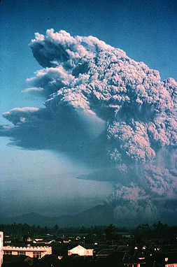 Galunggung eruption in 1982 | |
| Highest point | |
| Elevation | 2,168 m (7,113 ft) |
| Listing | Ribu |
| Coordinates | 7°15′24″S 108°04′37″E |
| Geography | |
 Galunggung Location on Java | |
| Location | West Java, Indonesia |
| Geology | |
| Mountain type | Stratovolcano |
| Last eruption | January 1984[1] |
For the first time since 1982 after eruptions finished and conditions seemed normal, on February 12, 2012, the status was upgraded to Alert based on changes in conditions.[2] [3] On 28 May 2012, it was lowered from 2 back to 1 (On a scale of 1–4).
1822 eruption
Galunggung had its first historical eruption in 1822 that produced pyroclastic flows and lahars that killed 4,011 people.[4]
Hazardous eruption of 1982


The last major eruption on Galunggung was in 1982, which had a Volcanic Explosivity Index of 4 and indirectly killed 18 people in traffic accidents and by starvation. This eruption also brought the dangers of volcanic ash to aviation to worldwide attention, after two Boeing 747 passenger jets flying downwind of the eruption suffered temporary engine failures and damage to exterior surfaces, both planes being forced to make emergency landings at Jakarta airport.
One plane, a British Airways aircraft traveling from Kuala Lumpur, Malaysia to Perth, Australia carrying 240 passengers, accidentally entered the ash cloud during night in June 1982 150 km (93 mi; 81 nmi) downwind of the volcano. All four engines failed due to the buildup of volcanic ash, and the aircraft descended for 16 minutes, losing 7,500 m (24,606 ft) of its 11,500 m (37,730 ft) altitude, until the crew managed to restart the engines and land in Jakarta.[5]
The following month, a Singapore Airlines aeroplane with approximately 230 passengers aboard also inadvertently entered the cloud at night, and three of its four engines stopped. The crew succeeded in restarting one of the engines after descending 2,400 m (7,874 ft). Both aircraft suffered serious damage to their engines and exterior surfaces.[6]
Historical avalanche deposits

A hummocky deposit known as the Ten Thousand Hills of Tasikmalaya attracted the attention of early-20th-century geologists. Houses were built on the hummocks since they provided good defence against hostile people, and being above the paddy fields were free of mosquitoes and rats.
Originally, it was thought that either it had been formed by a lahar caused by the release of the waters of the crater lake, or that it was man-made, composed of rocks and boulders dumped there after being cleared from paddy fields.
However, in the light of the Mount St. Helens eruption of 1980 and from examination of the Mount Shasta deposits, it has become clear that the hummocks are a debris-avalanche deposit. Like these mountains, Galunggung has a horseshoe-shaped crater indicating a massive landslide, and examination of shattered lava blocks revealed them to be similar to deposits on the other two volcanoes. According to radiocarbon dating of samples taken from a lava flow, the landslide happened within the last 23,000 years.
See also
- Volcanoes of Java
- List of volcanoes in Indonesia
- List of volcanic eruptions by death toll
References
- "Galunggung". Global Volcanism Program. Smithsonian Institution. Retrieved 2021-06-24.
- "Sejak 1982, Baru Kali ini Galunggung Berstatus Waspada (in Indonesian)". February 14, 2012. Archived from the original on September 7, 2012.
- Suwarni, Yuli Tri (February 13, 2012), "Mt. Galunggung status raised to alert", The Jakarta Post, archived from the original on February 14, 2012
- "Volcano World - Galunggung". volcano.oregonstate.edu. 27 January 2021.
- Ranter, Harro. "ASN Aircraft accident Boeing 747-236B G-BDXH Jakarta". aviation-safety.net. Aviation Safety Network. Retrieved 2021-12-09.
{{cite web}}: CS1 maint: url-status (link) - "A Singapore Airlines jumbo jet flew into a plume..." UPI.
External links
 Media related to Galunggung at Wikimedia Commons
- S. Brantley & H. Glicken (1986). "Volcanic Debris Avalanches". Earthquakes & Volcanoes. 18 (6): 195–206. Retrieved 2011-08-20.
- NOAA facts and figures about Galunggung
- Volcanological Survey of Indonesia
- Official website of Indonesian volcanoes at USGS
| Authority control |
|
|---|
На других языках
[de] Galunggung
Der Gunung Galunggung (indonesisch Gunung „Berg“) ist ein aktiver Vulkan auf der indonesischen Insel Java. Er liegt 40 Kilometer ostnordöstlich des Papandayan und 16 Kilometer nordwestlich der Stadt Tasikmalaya mit mehr als 700.000 Einwohnern, für die er eine direkte Gefahr darstellt.- [en] Galunggung
[es] Galunggung
Galunggung (en indonesio Gunung Galunggung), es un estratovolcán ubicado en la Isla de Java, en Indonesia.[fr] Galunggung
Le Galunggung, en indonésien Gunung Galunggung, est un volcan d'Indonésie situé dans l'ouest de Java. Deux de ses éruptions sont notables, celle de 1822 par son nombre de victimes s'élevant à 4 011 morts et celle de 1982 qui provoque l'arrêt des réacteurs de deux avions de ligne qui réussissent néanmoins à les redémarrer, évitant ainsi un crash.[it] Galunggung
Il Galunggung (in indonesiano: Gunung Galunggung) è un stratovulcano attivo presente sull'isola di Giava, a circa 80 km da Bandung, capoluogo della provincia di Giava Occidentale (e a 25 km dalla città di Garut), in Indonesia. Appartiene all'Arco di Sonda, che attraversa Sumatra, Giava e Bali ed è prodotto dalla subduzione della placca australiana sotto quella euroasiatica.[ru] Галунггунг
Галунггунг (индон. Gunung Galunggung) — вулкан в провинции Западная Ява, Индонезия.Другой контент может иметь иную лицензию. Перед использованием материалов сайта WikiSort.org внимательно изучите правила лицензирования конкретных элементов наполнения сайта.
WikiSort.org - проект по пересортировке и дополнению контента Википедии