geo.wikisort.org - Island
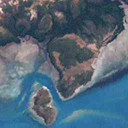
Port Lihou Island or Yeta (Yœtha beard) is an island in the Torres Strait, in Queensland's north between the Australian mainland and Papua New Guinea. It lies off the south coast of Muralag, separated by a channel that is three kilometres (1.9 miles) long but only a few metres wide at the north-eastern end (170 m (558 ft) at the south-western end). It is approximately 2.8 by 2.8 km (1.7 by 1.7 miles) in size. The area is 3.97 square kilometres (1.53 square miles).
This article needs additional citations for verification. (February 2014) |
Since May 2001 the Kaurareg people have held the native title rights to most of the island.[1]
Yeta is the name given by the Muralag/Kaurareg people. Its English name of Port Lihou was given by Lieutenant John Lihou, R.N., in 1823.
Lihou, then Master of the merchant ship Zenobia, was on passage from Manila to South America and had chosen a route through Torres Strait. This was the first occasion a ship was navigated through Torres Strait from west to east. It was also the first occasion a ship was navigated through the Coral Sea from Torres Strait, south-eastward to the south-ward of New Caledonia.
The Zenobia entered Endeavour Strait in January 1823, and discovered a shallow port on the south coast of Prince of Wales Island, subsequently named Port Lihou.
See also
References
- "Kaurareg Native Title Aboriginal Corporation". Native Title Corporations. Australian Institute of Aboriginal and Torres Strait Islander Studies (AIATSIS). Retrieved 24 December 2013.
List of Torres Strait topics | |||||||||||||||||||
|---|---|---|---|---|---|---|---|---|---|---|---|---|---|---|---|---|---|---|---|
| Torres Strait Islands, islets, and cays |
| ||||||||||||||||||
| People, culture, communities and languages |
| ||||||||||||||||||
| Governance and legal matters |
| ||||||||||||||||||
| Buildings and structures | |||||||||||||||||||
| Other |
| ||||||||||||||||||
This Far North Queensland geography article is a stub. You can help Wikipedia by expanding it. |
На других языках
[de] Port Lihou Island
Port Lihou Island, auch Yeta oder Yata genannt, ist eine unbewohnte australische Insel im Süden des Archipels der Torres-Strait-Inseln. Sie liegt in der Port Lihou-Bucht direkt vor der Südostküste von Prince-of-Wales Island, von dieser vollständig durch einen allerdings nur wenige Meter breiten Wasserlauf getrennt. Rund 400 Meter vor der Südwestküste liegt das wesentlich kleinere Packe Island.- [en] Port Lihou Island
Другой контент может иметь иную лицензию. Перед использованием материалов сайта WikiSort.org внимательно изучите правила лицензирования конкретных элементов наполнения сайта.
WikiSort.org - проект по пересортировке и дополнению контента Википедии