geo.wikisort.org - Island
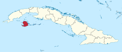
Isla de la Juventud[4] (Spanish pronunciation: [ˈizla ðe la xuβenˈtuð]; English: Isle of Youth) is the second-largest Cuban island (after Cuba's mainland) and the seventh-largest island in the West Indies (after mainland Cuba itself, Hispaniola, Jamaica, Puerto Rico, Trinidad, and Andros Island). The island was called the Isle of Pines (Spanish: Isla de Pinos) until 1978. It has an area 2,200 km2 (850 sq mi) and is 50 km (31 mi) south of the island of Cuba, across the Gulf of Batabanó. The island lies almost directly south of Havana and Pinar del Río and is a Special Municipality (2,419 km2 (934 sq mi)), not part of any province and is therefore administered directly by the central government of Cuba. The island has only one municipality, also named Isla de la Juventud.
This article needs additional citations for verification. (February 2020) |
Isla de la Juventud | |
|---|---|
Special Municipality of Cuba | |
 Regional map | |
 Coat of arms | |
 | |
| Country | Cuba |
| Capital | Nueva Gerona |
| Area | |
| • Total | 2,419 km2 (934 sq mi) |
| Elevation | 303 m (994 ft) |
| Population (2012 census)[2] | |
| • Total | 84,751 |
| • Density | 35/km2 (91/sq mi) |
| Time zone | UTC-5 (EST) |
| Area code | +53-061 |
| HDI (2019) | 0.832[3] very high · 2nd of 16 |
| Website | https://www.redisla.gob.cu/es/ |

The largest of the 350 islands in the Canarreos Archipelago (Archipiélago de los Canarreos), the island has an estimated population of 83,544 (in 2019).[5] The capital and largest city is Nueva Gerona in the north, and the second largest and oldest city is Santa Fe in the interior. Other communities include Columbia, La Demajagua (formerly Santa Bárbara),[6] Mac Kinley, Cuchilla Alta, Punta del Este, Sierra de Caballos and Sierra de Casas.
History
Little is known of the pre-Columbian history of the island, though a cave complex near the Punta del Este beach preserves 235 ancient drawings made by the native population. The island was first sighted by Europeans in 1494 during Christopher Columbus's second voyage to the New World.
Columbus named the island La Evangelista, claiming it for Spain. The island was also known, at various points in its history, as Isla de Cotorras (Isle of Parrots) and Isla de Tesoros (Treasure Island).
Pirate activity in and around the area left its trace in English literature; notably, Treasure Island by Robert Louis Stevenson, and Peter Pan by J. M. Barrie, each drawing on accounts of the island and its native and pirate inhabitants, by reflecting the long dugout canoes that both pirates and the indigenous peoples used, and the American crocodile (Crocodylus acutus).
Following its defeat in the Spanish–American War and the Cuban War of Independence, Spain dropped all claims to Cuba under the terms of the 1898 Treaty of Paris. The Platt Amendment of 1901, which defined Cuba's boundaries for the purposes of U.S. authorities, left the U.S. position on sovereignty over the then Isla de Pinos undetermined. This led to competing claims to the island by the United States and Cuba.[7] In 1907, the U.S. Supreme Court decided, in Pearcy v. Stranahan, that control of the island was a political decision, not a judicial one.[8] In 1916, a pamphlet titled Isle of Pines: American or What? called for the U.S. to annex or purchase the island to settle the issue.[9]
In 1904, Cuba and the United States negotiated and signed the Hay-Quesada Treaty, which recognized Cuba's sovereignty over the island. The U.S. Senate ratified this agreement on March 13, 1925, over the objections of some four hundred United States citizens and companies, who owned or controlled about 95% of the island's land.[10][11][12]
Prior to 1976, the island was part of La Habana Province. With the political and administrative reorganization of Cuban provinces in 1976, the island was given the status of "special municipality".[13]
Fidel Castro presided at a ceremony changing the name of the island from Isla de Pinos to Isla de la Juventud on 3 August 1978.[14] This was the realization of a promise that he had made in 1967, when he said "Let’s call it the Isle of Youth when the youth have done something grand with their work here, when they have revolutionized the natural environment, when they see the fruits of their labor and have revolutionized society here."[15]
Geography and economy
Much of the island is covered in pine forests, which is the source of the island's large lumber industry (as well as its original name). The northern region of the island has low ridges from which marble is quarried, while the southern region is an elevated plain. Agriculture and fishing are the island's main industries, with citrus fruit and vegetables being grown. A black sand beach was formed by volcanic activity.
The island has a mild climate but is known for frequent hurricanes. It is a popular tourist destination, with many beaches and resorts, including Bibijagua Beach. Until the Cuban government expropriated all foreign-owned property in the early 1960s, much land was owned by Americans, and the island contained a branch of the Hilton Hotels chain.
Demographics
In the 2012 official census, the Special Municipality of Isla de la Juventud had a population of 84,751. The racial makeup of the population was white 50,732 (59.9%), mestizo or mulatto 26,013 (30.7%) and black 8,006 (9.4%). [2] With a total area of 2,419.27 km2 (934.09 sq mi),[16] the Municipality had a population density of 35.8/km2 (93/sq mi).
"Caimaneros", the inhabitants of the south coast of the island, are descended from settlers from the Cayman Islands and Jamaica, and are English-speaking Cubans.
Transportation
The main transportation to the island is by boat or aircraft. Hydrofoils (kometas) and motorized catamarans will make the journey from Batabanó to Nueva Gerona in between two and three hours. A much slower and larger cargo ferry takes around six hours to make the crossing but is cheaper.
Presidio Modelo
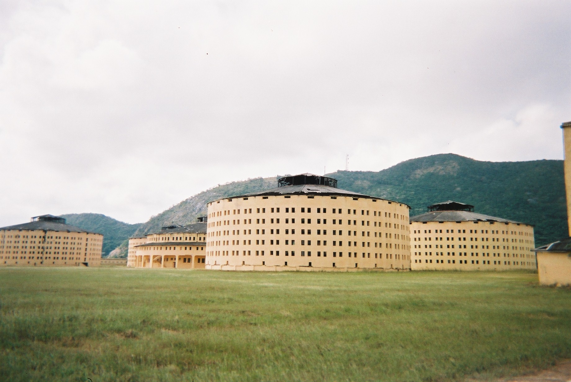
The Presidio Modelo was erected in 1926 and 1928. The model panopticon penitentiary is on the outskirts of Nueva Gerona.[10] It was the place where, after leading a failed attack on the Moncada Barracks in July 1953, Fidel Castro, along with his brother Raúl Castro, was imprisoned by the regime of Fulgencio Batista from 1953 to 1955.[17]
Following the Cuban Revolution, the same facility was used to imprison the new regime's enemies and political dissidents. They included Huber Matos, an officer in the revolutionary army who attempted to resign and who said he was tortured there.[18] Armando Valladares wrote a memoir describing the prison's harsh conditions and cruel treatment of political prisoners.[19] Presidio Modelo ceased functioning as a prison in 1967. It has been declared a national monument and its hospital rooms converted into a museum.
References
- "Lugar que ocupa el territorio según la superficie y la población" (PDF). Una MIRADA a Cuba (in Spanish). Oficina Nacional de Estadísticas. Cuba. 2010.
- 2012 Official Census Archived November 10, 2013, at the Wayback Machine | Province, City and ethnic group
- "Sub-national HDI - Area Database - Global Data Lab". hdi.globaldatalab.org. Retrieved January 24, 2022.
- Directorate of Intelligence (August 16, 2007). "The World Factbook — Cuba". Retrieved September 3, 2007.
- "Statistical Yearbook of Cuba Population 2020 Edition January-December 2019" (PDF). oficina nacional de estadística e información. Retrieved October 7, 2020.
- (in Spanish) Historical infos about Santa Bárbara and La Demajagua on EcuRed
- "The Isle of Pines". New York Times. November 16, 1905. Retrieved November 9, 2013.
The 'secession' from Cuba of a few American residents of the Isle of Pines is an incident of which National good faith and self-respect, we think, will compel the Government at Washington to take, not approving, but adverse notice.
- Tucker, Spencer C. (2009). The Encyclopedia of the Spanish-American and Philippine-American Wars. Santa Barbara, California: ABC-CLIO. p. 525. ISBN 978-1-85109-951-1.
- "Would Annex The Isle of Pines". New York Times. August 18, 1916. Retrieved November 9, 2013.
The proposed purchase by the United States of the Danish West Indies for $25,000,000 has started a renewal of agitation by American residents of the Isle of Pines for its purchase or acquisition from Cuba by the United States. The Isle of Pines Chamber of Commerce has issued a pamphlet entitled "Isle of Pines: American or What?"
- Ireland, Gordon (1941). Boundaries, possessions, and conflicts in Central and North America and the Caribbean. New York: Octagon Books. p. 333.
- Cuba's Island of Dreams: Voices from the Isle of Pines and Youth
- Neagle, Michael E. (2016), America's Forgotten Colony: Cuba's Isle of Pines (Cambridge University Press) - http://www.cambridge.org/us/academic/subjects/history/twentieth-century-american-history/americas-forgotten-colony-cubas-isle-pines?format=PB#tle1iZbI2eqyfs2G.97
- Encyclopedia of Cuba: People, History, Culture. Westport, Conn.: Greenwood Press. 2003. pp. 33, 41. ISBN 157356334X.
- "Cuba has New Name for 'Treasure Island'" (PDF). New York Times. August 4, 1978. Retrieved April 11, 2016.
- Gonzalez Suarez, Lisanka. "History and present state of Isla de la Juventud Cuba". Havana Journal Inc. Retrieved September 22, 2016.
- Government of Cuba (2002). "Population by Special Municipality" (in Spanish). Archived from the original on September 28, 2007. Retrieved October 2, 2007.
- Alex von Tunzelmann (2011). Red Heat: Conspiracy, Murder and the Cold War in the Caribbean. Simon & Schuster.
- "Huber Matos, a Moderate in the Cuban Revolution". American Experience. PBS. December 21, 2004. Retrieved January 26, 2011.
- Armando Valladares, Against All Hope (New York: Knopf, 1986)
External links
- Supreme Court decision of 1907
- Municipality page (Spanish)
- Image of the Presidio Modelo, Léopold Lambert, Weaponized Architecture: The Impossibility of Innocence, New York, 2012, p. 19.
Main settlements in Isla de la Juventud | ||
|---|---|---|
| ||
| |||||||||||||||||||||||||||
| |||||||||||||||||||||||||||
| |||||||||||||||||||||||||||
| |||||||||||||||||||||||||||
| |||||||||||||||||||||||||||
| |||||||||||||||||||||||||||
Authority control | |
|---|---|
| General | |
| National libraries | |
| Other |
|
На других языках
[de] Isla de la Juventud
Die Isla de la Juventud (dt. „Insel der Jugend“, oft auch engl. Isle of Youth; bis 1978 Isla de Pinos, dt. „Kieferninsel“) ist mit einer Fläche von 2204 km² die größte Nebeninsel Kubas und die sechstgrößte Insel in der Karibik. Sie ist keine eigene Provinz, sondern wird als Sonderverwaltungsgebiet (Municipio especial) behandelt. Die Insel liegt im Golf von Batabanó auf der karibischen Seite Kubas und gehört zum Archipiélago de los Canarreos. Nueva Gerona ist der Hauptort und mit 69.976 Einwohnern gleichzeitig die größte Stadt der Insel (Zensus 2012).- [en] Isla de la Juventud
[es] Isla de la Juventud
La isla de la Juventud (antes isla de Pinos) es una isla caribeña, la quinta en extensión del archipiélago de las Antillas Mayores, con una extensión territorial de 2200 km².[2] Junto a más de 600 cayos e islotes, conforma el archipiélago de los Canarreos, en la parte suroccidental de Cuba, junto al golfo de Batabanó, aproximadamente a 60 kilómetros de la isla de Cuba y 142 kilómetros de la ciudad de La Habana.[fr] Île de la Jeunesse
L’île de la Jeunesse (en espagnol : Isla de la Juventud) (île des Pins jusqu'en 1978) est la plus grande île cubaine après l'île de Cuba, et la sixième plus grande des Caraïbes. Comme c'est depuis 1830 un lieu de détention et de relégation (lieu dit de « rééducation » depuis 1960) et le site de la prison de Presidio Modelo, elle est considérée comme une municipalité spéciale administrée directement par le gouvernement central de Cuba, et non comme une province du pays.[it] Isola della Gioventù
L'isola della Gioventù (in spagnolo Isla de la Juventud) è un'isola facente parte dell'arcipelago di Cuba con un'estensione di circa 2 419 km², localizzata nel mar dei Caraibi. Dal punto di vista giuridico-amministrativo costituisce l'unica municipalità speciale della Repubblica, ed è dunque distinta da tutte le altre quindici province.[ru] Хувентуд
Хувенту́д (исп. Isla de la Juventud — остров Молодёжи), до 1978 года Пи́нос (исп. Pinos) — второй по величине остров и особый муниципалитет Республики Куба. Находится в 50 км от южного побережья острова Куба в архипелаге Лос-Канарреос. Площадь острова — 2200 км².Другой контент может иметь иную лицензию. Перед использованием материалов сайта WikiSort.org внимательно изучите правила лицензирования конкретных элементов наполнения сайта.
WikiSort.org - проект по пересортировке и дополнению контента Википедии