geo.wikisort.org - Island
Inisheer (Irish: Inis Oírr [ˈɪnʲɪʃ iːɾʲ], Inis Thiar [ˈɪnʲɪʃ hiəɾˠ] or Inis Oirthir [ˈɪnʲɪʃ ˈɛɾʲhəɾʲ]) is the smallest and most easterly of the three Aran Islands in Galway Bay, Ireland. With 281 residents as of the 2016 census, it is second-most populous of the Arans. Caomhán of Inis Oírr is the island's patron saint. There are five small settlements: Baile Thiar, Chapeltown (Baile an tSéipéil), Castle Village (Baile an Chaisleáin), Baile an Fhormna and Baile an Lorgain.
Native name: Inis Oírr | |
|---|---|
 | |
 | |
 Inisheer | |
| Geography | |
| Location | Atlantic Ocean |
| Coordinates | 53°03′29″N 9°31′39″W |
| Area | 1,448 acres (586 ha)[1] |
| Highest elevation | 62 m (203 ft)[1] |
| Administration | |
Ireland | |
| Province | Connacht |
| County | Galway |
| Demographics | |
| Population | 281 (2016)[2] |
| Pop. density | 48/km2 (124/sq mi) |
Name
The island was originally called Árainn Airthir, and later Inis Oirthir, which are thought to mean "eastern Aran" and "eastern island" respectively.[3] The second element is also found in the names Inishsirrer and Orior. According to Séamas Ó Murchú, the current official name, Inis Oírr, was brought into use by the Ordnance Survey Ireland. He says it may be a compromise between Inis Oirthir and the traditional local name Inis Thiar.[4]
Geology and geography
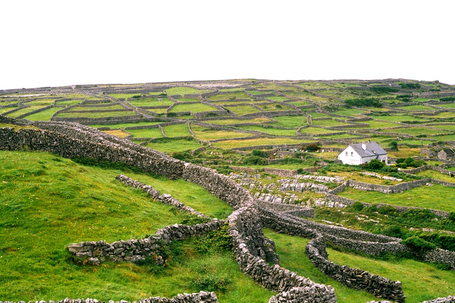
The island is geologically an extension of The Burren. The terrain of the island is composed of limestone pavements with crisscrossing cracks known as "grikes", leaving isolated rocks called "clints".
The limestones date from the Viséan period (Lower Carboniferous), formed as sediments in a tropical sea approximately 350 million years ago, and compressed into horizontal strata with fossil corals, crinoids, sea urchins and ammonites.
Glaciation following the Namurian phase facilitated greater denudation. The result is that Inisheer is one of the finest examples of a Glacio-Karst landscape in the world.[citation needed] The effects of the last glacial period (the Midlandian) are most in evidence, with the island overrun by ice during this glaciation. The impact of earlier Karstification (solutional erosion) has been eliminated by the last glacial period, so any Karstification now seen dates from approximately 10,000 years ago and the island Karst is thus recent.[citation needed]
Solutional processes have widened and deepened the grykes of the limestone pavement. Pre-existing lines of weakness in the rock (vertical joints) contribute to the formation of extensive fissures separated by clints (flat pavement-like slabs). The rock karstification facilitates the formation of subterranean drainage.
Climate and agriculture
The island has a temperate climate. Average air temperatures range from 15 °C (59 °F) in July to 6 °C (43 °F) in January. The soil temperature does not usually drop below 6 °C (43 °F). Since grass will grow once the temperature rises above 6 °C (43 °F), this means that the island (like the neighbouring Burren) has one of the longest growing seasons in Ireland, and supports diverse and rich plant growth.
Late May is the sunniest time,[5] and also likely the best time to view flowers, with the gentians and avens peaking (but orchid species blooming later).[original research?]
Flora and fauna
The island supports arctic, Mediterranean and alpine plants side-by-side, due to the unusual environment. Like the Burren, the Aran islands are known for their remarkable assemblage of plants and animals.[6] The grikes (crevices) provide moist shelter, thus supporting a wide range of plants including dwarf shrubs. Where the surface of the pavement is shattered into gravel, many of the hardier Arctic or alpine plants can be found. But when the limestone pavement is covered by a thin layer of soil, patches of grass are seen, interspersed with plants like the gentian and orchids.
Notable insects present include the butterfly the pearl-bordered fritillary (Boloria euphrosyne), brown hairstreak (Thecla betulae), marsh fritillary (Euphydryas aurinia) and wood white (Leptidea sinapis); the moths, the burren green (Calamia tridens), Irish annulet (Gnophos dumetata) and transparent burnet (Zygaena purpuralis); and the hoverfly Doros profuges.
History

In 1885 a burial site called Cnoc Raithní was discovered which dates back to 1500 BC. This is the earliest evidence of human settlement of the island.[7]
Saint Caomhán, the patron saint of Inisheer, according to some traditions, was the elder brother of Kevin of Glendalough. The ruins of Teampall Chaomháin in Inisheer cemetery have to be uncovered annually as the floor of it is well below the level of the sand. In the Middle Ages, the island was ruled by the O'Brien dynasty who provided most of the Kings of Thomond. This rule was exercised before the Anglo-Irish settled in Connacht in the 1230s.[citation needed]
The Tribes of Galway paid the O'Briens an annual tribute of twelve tuns of wine "in consideration of their protection and expenses in guarding the bay and harbour of Galway against pirates and coast plunderers." The remains of the 14th-century 'O'Brien's Castle' are sited near the island's highest point. In 1582 the O'Flahertys of Connemara captured it. Today O'Flahertys still live on the island. In 1652 it was given to the Cromwellian invasion force and the O'Flahertys were defeated. They saw no use for it and the castle was partially dismantled, it has been unoccupied since.[8][9]

The cargo vessel Plassey was shipwrecked off Inis Oírr on 8 March 1960 and has since been thrown above the high tide mark at Carraig na Finise on the island by strong Atlantic waves. The ship features in the opening credits of the TV Show Father Ted.
A group of local Islanders, the Inisheer Rocket Crew,[10] rescued the entire crew from the stricken vessel using a breeches buoy; an event captured in a pictorial display at the National Maritime Museum in Dún Laoghaire.

Antiquities
The following sites on the island are designated as National Monuments:
- Creggankeel Fort (NM 41.01)
- Grave of the Seven Daughters (NM 41.02)
- St. Gobnet's Church (NM 41.05)
- Cnoc Raithní (NM 41.06)
- O'Brien's Castle (NM 41.07)
- St. Cavan's Church (NM 41.08)
Demographics
The table below reports data on Inis Oírr's population taken from Discover the Islands of Ireland (Alex Ritsema, Collins Press, 1999) and the Census of Ireland. Census data in Ireland before 1841 are not considered complete and/or reliable.
|
|
| ||||||||||||||||||||||||||||||||||||||||||||||||||||||||||||||||||||||||||||||||||||
| Source: Central Statistics Office. "CNA17: Population by Off Shore Island, Sex and Year". CSO.ie. Retrieved 12 October 2016. | ||||||||||||||||||||||||||||||||||||||||||||||||||||||||||||||||||||||||||||||||||||||
Transport
The island is reached by ferry from Rossaveal in Connemara and Doolin in County Clare as well as from the other Aran Islands. There is also a regional airport on each island which is served from Connemara Regional Airport by AerArann. A pier was opened in Doolin in June 2015 for commercial ferries serving the island.[11] Islanders travel by foot or car around the island. Tourists can avail of tours/taxi trips by horse and trap.[citation needed]
Language
Irish is still today the daily language of the approximately 260 permanent residents.[citation needed] In addition, many school pupils from the mainland come to the island to learn Irish in an environment where it is a living language in the local college, Coláiste Laichtín during the months of June, July and August.
Sport
Some of the limestone sea cliffs have attracted interest from rock-climbers,[12] though the bigger islands of Inis Mór and Inis Meáin are more popular. Diving is possible.[13]
In the media
The island gained some television exposure in the 1990s when it (and 'An Plassy') appeared in the opening credits of the sitcom Father Ted masquerading as the fictional Craggy Island.
Inis Oírr is mentioned in the song "The Return of Pan" by the band The Waterboys.
Inisheer is also the name of a well-known slow air written by Thomas Walsh from Dublin, after a visit to the island in the 1970s.[14][15][16]
Inis Oírr was discussed at length in the work of cultural anthropologist John Cowan Messenger under the name Inis Beag.[17][18]
Gallery
 Limestone pavement
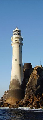
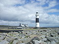 The lighthouse
 Eastern coastline
 Saint Caomhan's church, viewed from the priest's residence in the west through the nave and chancel arch to the altar in the east.
 Saint Caomhan's church with Caomhan's grave (Leaba Caomhan) in the background.
 Saint Gobnait's church
 Saint Fiachra's holy well near Cill Gobnait.
 O'Brien fort near the summit of Inisheer. Northern and western elevations
 View walking from pier towards beach / O'Brien's Castle
 Áras Éanna, arts and cultural center
 Tobar Éinne (Tobar Éanna), Saint Enda's holy well on Inis Oirr
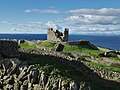 O'Brien's Castle, built in the 14th century


References
- "OSI Maps, 6" Cassini Maps". osi.ie. Ordnance Survey Ireland. Retrieved 9 May 2022.
- "Populated off-shore islands". gov.ie. Department of Rural and Community Development. Retrieved 8 May 2022.
The main inhabited offshore islands included in the 2016 census [..] Co. Galway [..] Inis Oírr* [..] 281
- "Inis Oírr/Inisheer". Placenames Database of Ireland. (see scanned records)
- Ó Murchú, Séamas. "An tainm áite Inis Oírr" in Éigse 26 (1992), pp. 119–123.
- Éireann, Met. "Met Éireann - The Irish Weather Service". www.met.ie.
- Webb, D. A. (1961–1963). "Noteworthy Plants of the Burren: A Catalogue Raisonné". Proceedings of the Royal Irish Academy, Section B. Royal Irish Academy. 62: 117–34. ISSN 0035-8983. JSTOR 20494847.
- "Inis Oírr (Inisheer) Island".
- "O'Brien's Castle". 2 May 2017.
- "OBriens Castle Inis Oirr Aran Islands Ireland". Archived from the original on 30 March 2009.
- "Scotch on the rocks - Independent.ie".
- "New Doolin Pier. Official blessing and opening ceremony. - Visit Doolin". 21 June 2015.
- "Aran Islands - Irish Climbing Online Wiki". wiki.climbing.ie.
- "Scuba diving ireland". Archived from the original on 17 May 2013. Retrieved 8 October 2013.
- Thoman Walsh, irishtunecomposers.weebly.com, retrieved 14 Aug. 2017
- The tune Inisheer, thesession.org, retrieved 14. Aug. 2017
- Inisheer, oh Inisheer; The Story of an Irish Air, www.folkworld.de, retrieved 14. Aug. 2017
- Rural Community Studies in Europe. Pergamon Press. 1981. p. 88. ISBN 9781483146256.
Inis Beag – a fictional name for Inisheer
- Ó Giolláin, Diarmuid (2000). Locating Irish Folklore: Tradition, Modernity, Identity. Cork University Press. pp. 183.
inis beag inisheer -wikipedia.
External links
 Inis Oírr travel guide from Wikivoyage
- Official tourism website for Inis Oírr and the Aran Islands
Places in County Galway | ||
|---|---|---|
County town: Galway | ||
| Towns |  | |
| Villages |
| |
| Townlands / places |
| |
| Baronies |
| |
| Islands | ||
| ||
Lighthouses in Ireland | ||
|---|---|---|
Lighthouses are shown in anti-clockwise sequence beginning from the north and proceeding west, south, east, and back to north. | ||
| County Donegal |
|  |
| County Sligo |
| |
| County Mayo |
| |
| County Galway |
| |
| County Clare |
| |
| County Kerry |
| |
| County Cork |
| |
| County Waterford |
| |
| County Wexford | ||
| County Wicklow | ||
| County Dublin | ||
| County Louth | ||
| County Down |
| |
| County Antrim |
| |
| ||
Authority control | |
|---|---|
| General |
|
| National libraries | |
На других языках
[de] Inis Oírr
Inis Oírr [.mw-parser-output .IPA a{text-decoration:none}ˌɪnʲɪʃ ˈiːɾʲ] (anglisiert Inisheer) ist eine Insel an der Westküste des County Galway in Irland. Der englische Name ist eine lautliche Nachbildung des irischen Namens. Daneben existieren zwei weitere irischsprachige Bezeichnungen für die Insel, Inis Thiar bzw. Inis Oirthir. Jedoch ist Inis Oírr seit einer Gesetzesänderung im Jahr 2004 der einzige offizielle Name.[2] Als Teil der Aran-Inseln ist Inis Oírr die kleinste bewohnte und östlichste Insel der Gruppe.- [en] Inisheer
[fr] Inis Oírr
Inis Oírr (aussi appelé Inis Thiar ou Inis Oirthir en irlandais ; en anglais : Inisheer) est la plus petite et la plus orientale des îles d'Aran, dans la baie de Galway, en Irlande.[it] Inis Oírr
Inis Oírr /ˌiniʃ ˈiːr/ (in gaelico irlandese: Inis Thiar o Inis Oirthir /ˌiniʃ ˈirhəx/, Inisheer in inglese) è la più piccola per dimensione delle tre isole Aran, nella Baia di Galway, Irlanda. È la seconda per abitanti e quella più orientale del noto arcipelago, oltre che la più vicina alla terraferma irlandese (precisamente al Clare).[ru] Инишир
Инишир (ирл. Inis Oírr[1], [ˈɪnɪɕ iːr]/[ˈɪnɪɕ siːr], англ. Inisheer) — самый маленький и восточный из островов Аран[2], расположенный в заливе Голуэй. Его название и переводится как «восточный остров». На острове площадью 5,67 км² (3х2) проживает 249 чел. (2011).[3].Другой контент может иметь иную лицензию. Перед использованием материалов сайта WikiSort.org внимательно изучите правила лицензирования конкретных элементов наполнения сайта.
WikiSort.org - проект по пересортировке и дополнению контента Википедии