geo.wikisort.org - Island
Hunga Tonga–Hunga Haʻapai (![]() listen (help·info)) is a submarine volcano in the South Pacific located about 30 km (19 mi) south of the submarine volcano of Fonuafoʻou and 65 km (40 mi) north of Tongatapu, Tonga's main island.[3] It is part of the highly active Kermadec-Tonga subduction zone and its associated volcanic arc, which extends from New Zealand north-northeast to Fiji, and is formed by the subduction of the Pacific Plate under the Indo-Australian Plate.[4][5] It lies about 100 km (62 mi) above a very active seismic zone.[5][6]
listen (help·info)) is a submarine volcano in the South Pacific located about 30 km (19 mi) south of the submarine volcano of Fonuafoʻou and 65 km (40 mi) north of Tongatapu, Tonga's main island.[3] It is part of the highly active Kermadec-Tonga subduction zone and its associated volcanic arc, which extends from New Zealand north-northeast to Fiji, and is formed by the subduction of the Pacific Plate under the Indo-Australian Plate.[4][5] It lies about 100 km (62 mi) above a very active seismic zone.[5][6]
| Hunga Tonga–Hunga Haʻapai | |
|---|---|
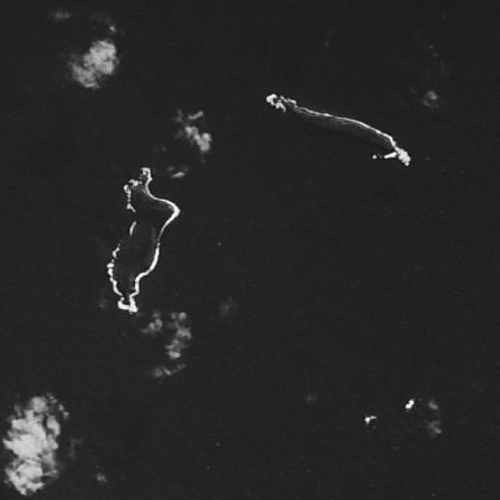
 The islands of Hunga Tonga (right side) and Hunga Haʻapai (left side), in February 2022. | |
| Highest point | |
| Elevation | 114 metres (374 ft)[1] |
| Listing | List of volcanoes in Tonga |
| Coordinates | 20.536°S 175.382°W |
| Geography | |
| Location | Tonga Islands |
| Geology | |
| Mountain type | Submarine volcano |
| Last eruption | 20 December 2021 – 15 January 2022[2] |
 An interactive map of Hunga Tonga–Hunga Haʻapai | |
The volcano rises around 2,000 m from the seafloor and has a caldera which – on the eve of the 2022 eruption – was roughly 150 m below sea level and 4 km at its widest extent.[7] The only major above-water part of the volcano are the twin uninhabited islands[8] of Hunga Tonga and Hunga Haʻapai, which are respectively part of the northern and western rim of the caldera.[3][7] As a result of the volcano's eruptive history, the islands existed as single landmass from 2015 to 2022: they were merged by a volcanic cone in a VEI 2 volcanic eruption in 2014–2015,[3][7] and were separated again by a more explosive eruption in 2022, which also reduced the islands in size.[2][9]
Its most recent eruption in January 2022 generated a tsunami that reached as far as the coasts of Japan and of the Americas and a volcanic plume that reached 58 km (36 mi) into the mesosphere. As of May 2022 the eruption is the largest volcanic eruption in the 21st century. Hunga Tonga–Hunga Haʻapai likely had a previous major explosive eruption in the late 11th or early 12th century (possibly in 1108). Several known historical eruptions occurred in 1912, 1937, 1988, 2009, 2014–15 and 2021–22.
Volcano and caldera
Hunga Tonga–Hunga Haʻapai is a submarine volcano in the Kermadec-Tonga Ridge in South Pacific, a ridge formed by the convergent boundary where the Pacific Plate is subducted by the Indo-Australian Plate, forming a long volcanic and island chain. Hunga Tonga–Hunga Haʻapai volcano lies almost completely underwater, with the exception of two small volcanic islands, Hunga Tonga and Hunga Haʻapai. They are, respectively, the remnants of the northern and western rim of the volcano's caldera.[3][10] The volcano's base at the seafloor is approximately 20 km in diameter,[11] rising roughly 2,000 m towards the sea surface. Before the 2022 eruption, the volcano's caldera was roughly 150 m below sea-level, and had a size of 4 × 2 km.[7] Its northern and southern portions were filled by volcanic deposits from previous eruptions.[7] Before the 2015 eruption, the two subaerial islands were about 1.6 km (0.99 mi) apart,[12] and were each about 2 km (1.2 mi) long. They are both composed largely of andesite and layered tephra deposits,[5][6] with steep rocky cliffs.[13] This andesite tends to be of the basaltic type.[14]
Samples from the islands suggest a long eruptive history.[7] One pyroclastic flow was dated to 1040–1180 CE, correlating to ash deposits found on Tongatapu, and to an unknown tropical eruption in 1108 CE that had produced 1 °C of global cooling.[7] The caldera is believed to have been formed by this eruption.[7] Submarine eruptions at a rocky shoal – about 3.2 km (2.0 mi) southeast of Hunga Haʻapai and 3 km (1.9 mi) south of Hunga Tonga – were reported in 1912 and 1937; both eruptions had a Volcanic Explosivity Index (VEI) of 2.[3] Another eruption in Hunga occurred from a fissure 1 km (0.62 mi) south-southeast of Hunga Haʻapai island in 1988; this eruption had a VEI of 0.[3] The 2009 eruption[3] arose from two vents located to the south and northwest of Hunga Haʻapai. The tephra deposited around each vent became connected to the island and nearly tripled its size, but such deposits disappeared with erosion in the following months.[13]
Geography


Islands
Hunga Tonga and Hunga Haʻapai are the only subaerial parts of the volcano. Hunga Tonga is the eastern island, while Hunga Haʻapai is the western one. They are part of Tonga's Haʻapai group of islands,[15] an island arc formed at the convergent boundary where the Pacific Plate subducts under the Indo-Australian Plate.[6][16][17]
Before the 2014–15 eruption, which connected them into a single island, the islands were separated by about 1.6 km (0.99 mi) of ocean water.[12] Before the 2022 eruption, the highest point in the former Hunga Tonga reached an elevation of 149 m (489 ft), while Hunga Haʻapai was only 128 m (420 ft) above sea level.[3] Neither island was large: before they were connected in 2015, each island was about 2 km (1.2 mi) long, with Hunga Tonga being roughly 390,000 m2 (0.15 sq mi) and Hunga Haʻapai 650,000 m2 (0.25 sq mi) in size.[18] They are much smaller after the 2022 eruption. Neither island was developed due to a lack of an acceptable anchorage, although there were large guano deposits on each island.[15][19]
After the 2015 eruption, the smaller Hunga Tonga island, approximately 1.5 km (0.93 mi) to the northeast of Hunga Haʻapai, became attached to the crater via a 380 m (1,250 ft)-wide tombolo, and further sandy deposits had built up at the southern end of the crater's connection with Hunga Haʻapai. The caldera itself has eroded rapidly in the southeast, originally allowing an opening that flooded the crater with seawater to form a bay. This bay has later become separated from the open ocean by a shallow sandbar, forming a lagoon. Initially it was believed that the entire island would be eroded rapidly, but by 2017, scientists believed that the process could take decades.[20]
The islands figure in Tongan mythology as one of the few islands which were not overfished, and hence thrown down from heaven to land on earth.[21][22] Tongans called them the islands which "jump back and forth" (i.e. suffer earthquakes).[21] The first Europeans to see the islands were those with the Dutch explorers Willem Schouten and Jacob Le Maire in 1616. The British explorer Captain James Cook visited them several times in 1777 and learned their Tongan names.[23][24][25]
History
2009 eruption

On 16 March 2009, a submarine eruption near Hunga Tonga–Hunga Haʻapai began spewing steam, smoke, pumice, and ash thousands of feet into the sky.[26][lower-alpha 1] By 21 March, Tonga's chief geologist, Kelepi Mafi, reported lava and ash issuing from two vents – one on the uninhabited island Hunga Haʻapai and another about 100 m (330 ft) offshore. The eruption had filled the gap between the two vents, creating new land surface that measured hundreds of square metres.[30][31] The eruption devastated Hunga Haʻapai, covering it in black ash and stripping it of vegetation and fauna.[31]
The volcanic eruption drew worldwide attention. The volcano was featured in a segment of the television program Angry Planet in 2009.[32]
2014–2015 eruption

In November–December 2014, volcanic plumes and a series of earthquakes at volcanoes occurred north of Tonga for several weeks, indicating resumed volcanic activity in the area.
A new eruption began at Hunga Tonga–Hunga Haʻapai on 19 December 2014. Local fishermen reported a tall white steam plume rising from the ocean over the undersea volcanic mount. Satellite images taken on December 29 showed the eruption continuing, with a smoke and ash plume rising from the site, and discolored seawater (possibly caused by smoke and ash released below the surface, or by disturbance of the seabed).[33] The eruption continued into 2015, with a tall ash cloud rising 3 km (9,800 ft) into the sky on 6 January 2015.[34]
The eruption entered a new stage on 11 January 2015, when the volcano began sending ash plumes as high as 9 km (30,000 ft) into the sky. An Air New Zealand flight on 12 January had to be diverted to Samoa, while a number of other flights between New Zealand and Tonga were cancelled.[35] An ash plume reached 4.5 km (15,000 ft) on January 13. Officials identified two vents, one on Hunga Haʻapai and another about 100 m (330 ft) offshore and underwater.[36] Large rocks and wet, dense ash were being ejected up to 400 m (1,300 ft) into the air.[36][37] By 16 January, a new island had been formed by the explosion.[38] Tongan officials estimated the new island to be 1 km (0.62 mi) wide, 2 km (1.2 mi) long, and 100 m (330 ft) high,[36][37] although geologists said the new island would probably exist only a few months until ocean waves wore it down.[39] Ash and acid rain were falling in an area about 10 km (6.2 mi) from the new island, and Hunga Tonga and Hunga Haʻapai had both been denuded of vegetation.[36][37]
Despite the volcano's eruption, which was spewing a steam cloud 1 km (0.62 mi) into the air,[37] international flights to Tonga resumed on 16 January, as volcano and aviation experts deemed the eruption no longer a threat to airliners.[36]
Geologists from Tonga and New Zealand who visited the volcano on January 19 said the eruption had quieted in the last 24 hours. They noted that nearly all the eruption was now coming from the vent on the new island, with steam clouds rising to a height of 7 to 10 km (4.3–6.2 mi), and ash and rock being thrown to a height of about 200 to 300 m (660–980 ft). Emission of ash was limited, with magma rocks hitting the ocean causing some steam explosions. The team found no floating volcanic debris, such as pumice rafts, and the smell of volcanic gases was intermittent. Tongan officials established a zone 20 km (12 mi) in diameter around the island to protect visitors from rock, ash, and acid rain.[40]
Tongan officials declared the eruption at an end on 26 January,[41] after observing no new gas, ash, or rock emerging from the island vent.[42] By this time, the island was 1 to 2 km (0.62 to 1.24 mi) wide, 2 km (1.2 mi) long, and 120 m (390 ft) high.[41][42] The new island had joined with Hunga Haʻapai, and was about 200 m (660 ft) away from joining with Hunga Tonga.[41][42] Locals visiting the island said seabirds were nesting.[43]
In June 2015, entrepreneur Ian Argus Stuart became the first person to overnight on this new island formation. Spending 11 nights on the island, Stuart survived eating nothing but seagull eggs and squid. Stuart went to Hunga Tonga with the help of the Spanish explorer Alvaro Cerezo, who provides castaway experiences to remote desert islands around the planet.[44]
Post–2015 scientific study

In June 2017, French explorers Cécile Sabau and Damien Grouille landed the island from their sailing boat COLIBRI. Aside from taking some of the very few pictures of the island before it was decimated by the 2022 eruption, they collected a total of 16 rock samples, documented with GPS plotting and 3D pictures.[45]
This material was studied by scientists at NASA's Goddard Space Flight Center, led by Dr James B. Garvin. They studied Hunga Tonga–Hunga Haʻapai, using it as a model for volcanic shapes on Mars. In an article published in late 2017, the scientists concluded that Hunga Tonga–Hunga Haʻapai eroded in ways that are remarkably similar to the erosion patterns seen on similar landforms on Mars. The scientists noted that this suggested Mars was once flooded briefly by water, but that the water receded fairly quickly. They said that further study of the similarities between Hunga Tonga–Hunga Haʻapai and Martian volcanic landforms was needed.[46]
Another analysis of the samples showed that the volcanic ash that forms much of Hunga Tonga–Hunga Haʻapai reacted with the warm oceanic water around it. This chemical reaction turned the ash into much harder rock, and volcanologists believed the island would last for several decades rather than be eroded. This made Hunga Tonga–Hunga Haʻapai only the third volcanic island in the last 150 years to survive more than a few months.[46]
In October 2018, scientists visited the island and discovered that its surface was covered with gravel, sticky mud, and vegetation. The island was also populated by a variety of bird life. They also found that the island seemed to be eroding more quickly than previously thought, due to rainfall.[47][48]
December 2021–January 2022 eruption

On 20 December 2021 the volcano erupted, causing a large plume that was visible from Nukuʻalofa.[49] The Volcanic Ash Advisory Centre Wellington issued an advisory to airlines.[50] Explosions could be heard up to 170 kilometres (110 mi) away.[51] The initial eruption continued until 2 am on 21 December.[49] Activity continued, and on 25 December, satellite imagery showed that the island had increased in size.[52]
As activity on the volcano decreased, it was declared dormant on 11 January[53][54] before restarting on 14 January after the volcano sent an ash cloud 20 km (12 mi).[55] The Tongan government subsequently issued a tsunami warning.[56][57] On the next day, the volcano violently erupted again, about seven times more powerfully than the eruption on 20 December 2021. The initial volcanic plume rose to 58 kilometres (36 miles) into the mesosphere, the greatest height ever reported for a vapor plume.[58] There were numerous reports of loud booms across Tonga and other countries, such as Fiji and as far away as New Zealand and Australia. A boom was heard in Alaska, 10,000 kilometres (6213 miles) from the source seven hours after eruption.[59] The Met Office in the UK has also detected shockwaves from the eruption.[60] The eruption set off a massive atmospheric shock-wave travelling at about 300 m (1,000 ft) per second.[61] The energy released by the eruption is estimated to have been equivalent to 61 Megatons (of TNT),[62] more powerful than the largest nuclear bomb ever detonated. Near the eruption, the explosion damaged property, including shattered windows.[63] A tsunami warning was issued just after 5:30 p.m. by the Tonga Meteorological Services and the tsunami flooded coastal areas in Tonga.[64]
Two people were killed in Peru and two fishermen were injured in San Gregorio, California. Four deaths were confirmed in Tonga, including a British woman whose body was found after she went missing when the tsunami struck.[65][66][67][68]
According to a report in the journal Geophysical Research Letters, while comparable to other volcanic eruptions on some measures, the 2022 Hunga Tonga–Hunga Haʻapai eruption sent unprecedented amounts of water (H2O) vapor into the stratosphere.[69]
It was reported on 16 January that radar surveys before and after the eruption show that most of the then island had been destroyed, and only small parts remained.[9] These included remnants of Hunga Tonga and Hunga Haʻapai.[70]
A survey of the caldera by a remote operated vehicle in August 2022 found continuing signs of volcanic activity.[71]
See also
- List of volcanoes in Tonga
- List of islands and towns in Tonga
- Surtsey, another recently formed volcanic island in Iceland
- List of large volcanic eruptions
Footnotes
- The date the eruption began is uncertain. According to the Smithsonian Institution's Global Volcanism program, "Observers flying near the area of Hunga Tonga–Hunga Haʻapai (about 62 km NNW of Nukuʻalofa, the capital of Tonga) on 16 or 17 March reported seeing an eruption."[27] The report cites Keizo Gates' web log, dated 16 March 2009, which contains photos allegedly taken from civilian aircraft late on the afternoon of March 16.[28] The Smithsonian subsequently confirmed that the eruption began on 16 March.[29]
References
- "Hunga Tonga-Hunga Haʻapai". Global Volcanism Program. Smithsonian Institution. Archived from the original on 2 February 2022. Retrieved 2 February 2022.
- "Hunga Tonga-Hunga Ha'apai: Eruptive History". Global Volcanism Program. Smithsonian Institution. Archived from the original on 12 June 2022. Retrieved 12 June 2022.
- "Hunga Tonga–Hunga Ha'apai". Global Volcanism Program. Smithsonian Institution.
- Clift, Peter D.; Rose, Estelle F.; Shimizu, Nobumichi; Layne, Graham D.; Draut, Amy E.; and Regelous, Marcel. "Tracing the Evolving Flux From the Subducting Plate in the Tonga-Kermadec Arc System Using Boron in Volcanic Glass." Geochimica et Cosmochimica Acta. 65:19 (October 2001). doi:10.1016/S0016-7037(01)00670-6
- Gupta, Alok K. Igneous Rocks. Mumbai, India: Allied Publishers, 1998. ISBN 81-7023-784-X
- Ewart, A.; Bryan, W.B.; and Gill, J.B. "Mineralogy and Geochemistry of the Younger Volcanic Islands of Tonga, S.W. Pacific." Journal of Petrology. 14:3 (1973). doi:10.1093/petrology/14.3.429
- Cronin, S.J.; Brenna, M.; Smith, I.E.M.; Barker, S.J.; Tost, M.; Ford, M.; Tonga'onevai, S.; Kula, T.; Vaiomounga, R. (26 June 2017). "New volcanic island unveils explosive past". Science News by AGU. Eos. Vol. 98. doi:10.1029/2017EO076589. Archived from the original on 15 January 2022. Retrieved 16 January 2022.
- "New island 'now home to flowers and owls'". BBC News. 7 February 2019. Archived from the original on 18 July 2020. Retrieved 19 August 2020.
- "Pacific volcano: New Zealand sends flight to assess Tonga damage". BBC. 15 January 2022. Archived from the original on 16 January 2022. Retrieved 15 January 2022.
- Bryan, W.B.; Stice, G.D.; Ewart, A. (1972). "Geology, petrography, and geochemistry of the volcanic islands of Tonga". Journal of Geophysical Research. 77 (8): 1574–1575. Bibcode:1972JGR....77.1566B. doi:10.1029/JB077i008p01566. Archived from the original on 16 January 2022. Retrieved 16 January 2022.
- Croin, Shane (15 January 2022). "Why the volcanic eruption in Tonga was so violent, and what to expect next". The Conversation. Archived from the original on 15 January 2022. Retrieved 21 January 2022.
- Pacific Islands Pilot. London, UK: United Kingdom Hydrographic Office. 1969.
- Vaughan, R. Greg; Webleyb, Peter W. (1 December 2010). "Satellite observations of a surtseyan eruption: Hunga Ha'apai, Tonga". Journal of Volcanology and Geothermal Research. 198 (1–2): 177–186. Bibcode:2010JVGR..198..177V. doi:10.1016/j.jvolgeores.2010.08.017. Archived from the original on 21 January 2022. Retrieved 21 January 2022.
- Garvin, J.B.; Slayback, D.A.; Ferrini, V.; Frawley, J.; Giguere, C.; Asrar, G.R.; Andersen, K. (28 April 2018) [11 March 2018]. "Monitoring and modeling the rapid evolution of Earth's newest volcanic island: Hunga Tonga Hunga Ha'apai (Tonga) using high spatial resolution satellite observations". Geophysical Research Letters. 45 (8): 3445–3452. Bibcode:2018GeoRL..45.3445G. doi:10.1002/2017GL076621. PMC 6049963. PMID 30034048.
- Wells, Susan M.; Sheppard, Charles; Jenkins, Martin (1988). Coral Reefs of the World: Central and Western Pacific (Report). United Nations Environment Programme. ISBN 2-88032-945-0.
- Ewart, A. "A Petrological Study of the Younger Tongan Andesites and Dacites, and the Olivine Tholeiites of Niua Fo'ou Island, S. W. Pacific." Contributions to Mineralogy and Petrology. 58:1 (January 1976) doi:10.1007/BF00384740
- Hawkesworth, C.J.; Turner, S.P.; McDermott, F.; Peate, D.W.; and van Calsteren, P. "U-Th Isotopes in Arc Magmas: Implications for Element Transfer from the Subducted Crust." Science. 276:5312 (25 April 1997). doi:10.1126/science.276.5312.551
- Dahl, Arthur L. (1986). Review of the Protected Areas System in Oceania. IUCN Commission on National Parks and Protected Areas (Report). United Nations Environment Programme. ISBN 2-88032-509-9.
- Fletcher, Matt; Keller, Nancy J. (2001). Tonga. Oakland, California: Lonely Planet. ISBN 1-74059-061-9.
- "The world's youngest island". BBC. 11 December 2017. Archived from the original on 11 December 2017. Retrieved 12 December 2017.
- Gifford, Edward Winslow (1924). Tongan Myths and Tales. London, UK: The British Museum.
- Nunn, Patrick D. (November 2004). "Fished up or thrown down: The geography of Pacific island origin myths". Annals of the Association of American Geographers. 93: 2.
- Suren, Peter (2001). Essays on the History of the Discovery and Exploration of Tonga by the Europeans. Nukuʼalofa, Kingdom of Tonga: Friendly Islands Bookshop.
- Rutherford, Noel. (1977). Friendly Islands: A history of Tonga. Cambridge, UK: Oxford University Press. ISBN 0-19-550519-0.
- Cook, James, Captain (1999) [1771]. Beaglehole, John Cawte; Edwards, Philip (eds.). The Journals of Captain Cook. New York, NY: Penguin Classics. ISBN 0-14-043647-2.
- "Tongan inspection team heads to undersea volcano". phys.org/news. 19 March 2009. Archived from the original on 9 February 2019. Retrieved 7 February 2019.
- SI/USGS Weekly Volcanic Activity Report 11–17 March 2009 (Report). Smithsonian Institution / USGS. Archived from the original on 13 April 2009.
- Gates, Keizo (16 March 2009). "New Tonga eruption". Kzo.net. Archived from the original on 22 April 2016.
- SI/USGS Weekly Volcanic Activity Report 18–24 March 2009 (Report). Smithsonian Institution / USGS. Archived from the original on 2 March 2021.
- Percival, Jenny (21 March 2009). "Underwater volcano creates new island off Tonga". The Guardian. Archived from the original on 8 December 2016.
- "'No living thing left' as Tonga volcano erupts". Agence France Presse. 20 March 2009. Archived from the original on 6 July 2012 – via Google News.
- Angry Planet, "Entertainment", Cape Argus, 20 November 2009
- Klemetti, Erik (30 December 2014). "New eruption at Hunga Tonga–Hunga Ha'apai". Wired. Retrieved 9 January 2015; "Undersea eruption from Hunga Tonga–Hunga Ha'apai in Tonga, South Pacific Ocean". MODIS Web. NASA. 9 January 2015. Archived from the original on 10 January 2015. Retrieved 9 January 2015.
- "Hunga Tonga–Hunga Ha'apai". Global Volcanism Program, National Museum of Natural History. Smithsonian Institution. 7 January 2015. Archived from the original on 10 January 2015. Retrieved 9 January 2015.
- Tapaleao, Vaimoana (13 January 2015). "Tongan volcano eruption puts flights on alert". New Zealand Herald. Archived from the original on 13 January 2015. Retrieved 12 January 2015.
- "Tongan volcano creates new island". The Star. 16 January 2015. Archived from the original on 17 January 2015. Retrieved 16 January 2015.
- "Photos: Massive ash cloud in Tonga volcano eruption". TV New Zealand. 16 January 2015. Archived from the original on 17 January 2015. Retrieved 16 January 2015.
- "Tongan volcano forms new island". Radio Australia. 16 January 2015. Archived from the original on 16 January 2015. Retrieved 16 January 2015.
- Perry, Nick (21 January 2015). "New island created by underwater volcanic eruption in Tonga may soon disappear". The Independent. Archived from the original on 11 June 2020. Retrieved 21 January 2015.
- "Geo survey reports less ash coming from volcano". Matangi Tonga. Nukuʻalofa, Tonga. 19 January 2015. Archived from the original on 19 January 2015. Retrieved 19 January 2015.
The survey team, including two volcanologists from GNS-Science in New Zealand, visited the site, located on a NNW bearing 65 km from Vuna Wharf, on January 17, on board the VOEA Pangai. The site observation was sponsored by the New Zealand High Commission.
- "Volcanic eruption ends, leaving tiny ash island". Matangi Tonga. 26 January 2015. Archived from the original on 2 February 2015. Retrieved 26 January 2015.
- "Volcano eruption in Tonga declared over". Radio New Zealand. 26 January 2015. Archived from the original on 29 January 2015. Retrieved 26 January 2015.
- Pearlman, Jonathan (11 March 2015). "First photographs emerge of new Pacific island off Tonga". Daily Telegraph. Archived from the original on 28 April 2019. Retrieved 12 March 2015.
- "Real-life castaway: 'He's not afraid to die' (surviving on seagull eggs and squid)". News.com.au. 26 June 2015. Archived from the original on 19 November 2015. Retrieved 26 June 2015.
- Garvin, James; Slayback, D.; Ferrini, Vicki; Frawley, J.; Giguere, C.; Asrar, G.; Andersen, K. (26 March 2018). "Monitoring and Modeling the Rapid Evolution of Earth's Newest Volcanic Island: Hunga Tonga Hunga Ha'apai (Tonga) Using High Spatial Resolution Satellite Observations". Geophysical Research Letters. 45 (8): 3445–3452. Bibcode:2018GeoRL..45.3445G. doi:10.1002/2017GL076621. PMC 6049963. PMID 30034048. Archived from the original on 1 February 2022. Retrieved 1 February 2022.
- Chang, Kenneth (11 December 2017). "New Pacific Island Could Resemble Ancient Martian Volcanoes". The New York Times. Archived from the original on 14 December 2017. Retrieved 15 December 2017.
- Joshua Berlinger (5 February 2019). "Mud, vegetation on new Pacific island baffle scientists". CNN. Archived from the original on 5 February 2019. Retrieved 6 February 2019.
- New Tonga island 'now home to flowers and owls' Archived 7 February 2019 at the Wayback Machine, bbc.co.uk/news, accessed 7 February 2019
- Mary Lyn Fonua (21 December 2021). "Air NZ funeral flight to Tonga cancelled as Hunga eruption continues". Matangi Tonga. Archived from the original on 21 December 2021. Retrieved 21 December 2021.
- "VA Advisory". VAAC. 19 December 2021. Archived from the original on 20 December 2021. Retrieved 20 December 2021.
- "Undersea volcano sends plume of steam into the skies near Tonga". NewsHub. 21 December 2021. Archived from the original on 20 December 2021. Retrieved 21 December 2021.
- "Tonga volcano grows in size as eruption continues for sixth day". RNZ. 25 December 2021. Archived from the original on 25 December 2021. Retrieved 26 December 2021.
- Tonga Geological Services, Government of Tonga (11 January 2022). "7 Days with no further eruption from Hunga Volcano. It is now declared dormant". Archived from the original on 17 January 2022. Retrieved 17 January 2022 – via Facebook.
- "Hunga volcano quietens down, while pumice floats onto Tongatapu beaches". Matangi Tonga. 6 January 2022. Archived from the original on 7 January 2022. Retrieved 8 January 2022.
- "Underwater volcano Hunga-Tonga-Hunga-Ha'apai erupts again". Radio New Zealand. 14 January 2022. Archived from the original on 14 January 2022. Retrieved 15 January 2022.
- "Tsunami Marine Warning for Tonga". Government of Tonga. 14 January 2022. Archived from the original on 14 January 2022. Retrieved 14 January 2022.
- "Underwater volcano Hunga-Tonga–Hunga-Ha'apai erupts again". RNZ. 14 January 2022. Archived from the original on 16 January 2022. Retrieved 14 January 2022.
- "Tonga Volcano Plume Reached the Mesosphere". NASA. 17 February 2022. Archived from the original on 22 February 2022. Retrieved 22 February 2022.
Two weather satellites were uniquely positioned to observe the height and breadth of the plume. Together they captured what is likely the highest plume in the satellite record.
- "Hunga volcano eruption provides an explosion of data | Geophysical Institute". www.gi.alaska.edu. Retrieved 17 May 2022.
- Simons, Paul. "Pacific volcano eruption felt in Alaska and Britain". The Times. ISSN 0140-0460. Retrieved 17 May 2022.
- Armario, Christine (15 January 2022). "Tsunami waves reach West Coast as National Weather Service urges: 'Move off the beach'". The Washington Post. Archived from the original on 16 January 2022. Retrieved 15 January 2022.
- Díaz, J. S.; Rigby, S. E. (9 August 2022). "Energetic output of the 2022 Hunga Tonga–Hunga Ha'apai volcanic eruption from pressure measurements". Shock Waves. Bibcode:2022ShWav.tmp...37D. doi:10.1007/s00193-022-01092-4. ISSN 1432-2153. S2CID 251480018.
- "Waves crash through homes in Tonga following massive tsunami warning". Stuff. 15 January 2022. Archived from the original on 15 January 2022. Retrieved 15 January 2022.
- "Live updates: Tsunami warning for parts of NZ's North Island, waves crashing into Tonga". RNZ. 15 January 2022. Archived from the original on 15 January 2022. Retrieved 15 January 2022.
- Nicholas Parra (16 January 2022). "Reportan dos muertes y daños por tsunami en Perú: país no emitió alerta". Radio Bío-Bío (in Spanish). Archived from the original on 16 January 2022. Retrieved 16 January 2022.
- Jerimiah Oetting (15 January 2022). "Here are the impacts of the tsunami along the Monterey Bay". KAZU. Archived from the original on 16 January 2022. Retrieved 16 January 2022.
- "Tonga tsunami sparks 'unprecedented disaster', government says". BBC News. 18 January 2022. Archived from the original on 18 January 2022. Retrieved 18 January 2022.
- "Tonga tsunami: Body of British woman swept away by wave found". Sky News. 17 January 2022. Archived from the original on 17 January 2022. Retrieved 17 January 2022.
- Millán, L.; Santee, M. L.; Lambert, A.; Livesey, N. J.; Werner, F.; Schwartz, M. J.; Pumphrey, H. C.; Manney, G. L.; Wang, Y.; Su, H.; Wu, L. (16 July 2022). "The Hunga Tonga‐Hunga Ha'apai Hydration of the Stratosphere". Geophysical Research Letters. 49 (13): e2022GL099381. Bibcode:2022GeoRL..4999381M. doi:10.1029/2022GL099381. ISSN 0094-8276. PMC 9285945. PMID 35865735.
- "Dramatic Changes at Hunga Tonga-Hunga Ha'apai". NASA. 22 January 2022. Archived from the original on 22 February 2022. Retrieved 22 February 2022.
- "Unmanned vessel records continuing volcanic activity deep inside HTHH". Matangitonga. Matangi Tonga. 12 August 2022. Retrieved 12 August 2022.
External links
- "Hunga Tonga–Hunga Ha'apai". Global Volcanism Program. Smithsonian Institution. Retrieved 15 January 2022.
- The Rise and Fall of Hunga Tonga-Hunga Ha'apai – Robert Waterman – Esri
- "Underwater Volcano Erupts Off Tonga." BBC News. March 19, 2009. – Video showing the 18 March 2009, eruption
- "Expedition To A New Island" – Explorer George Kourounis sets foot on a brand new volcanic island
- "Hunga Tonga – The Volcano" – Local Tonga news of the 2022 eruption
На других языках
[de] Hunga Tonga-Hunga Haʻapai
Hunga Tonga-Hunga Haʻapai ist ein submariner Vulkan im Inselstaat Tonga im Pazifik. Er befindet sich in der Haʻapai-Inselgruppe, etwa 64 km nördlich von Tongatapu, der Hauptinsel von Tonga. Die namensgebenden Inseln Hunga Tonga und Hunga Haʻapai waren ursprünglich getrennt und wurden durch einen Vulkanausbruch Ende Dezember 2014 verbunden. Durch einen weiteren, deutlich stärkeren Vulkanausbruch im Januar 2022 wurde die ehemals 114 m hohe[1] Insel großflächig verändert und ist bis auf einzelne Felsspitzen, die noch über den Meeresspiegel ragen, verschwunden.[2][3]- [en] Hunga Tonga–Hunga Haʻapai
[es] Hunga Tonga
Hunga Tonga-Hunga Haʻapai es un volcán submarino situado unos 30 kilómetros al sureste de Fonuafoʻou, una isla que forma parte de la nación de Tonga.[1][fr] Hunga Tonga
Hunga Tonga est un volcan sous-marin du royaume des Tonga dans le sud-ouest de l'océan Pacifique. En 2009, une éruption crée deux îles nouvelles nommées Hunga Tonga et Hunga Ha'apai qui sont reliées par un isthme en 2015. En 2022, une forte éruption le détruit et redivise l'île en deux.[it] Hunga Tonga-Hunga Haʻapai
Hunga Tonga-Hunga Haʻapai è un vulcano sottomarino delle Tonga che fa parte della zona di subduzione delle Kermadec-Tonga, un'area geologicamente molto attiva che si estende dalla Nuova Zelanda fino a nord-ovest delle Figi, nell'Oceano Pacifico, dovuta alla subduzione della placca pacifica sotto alla placca indo-australiana.[ru] Хунга-Тонга-Хунга-Хаапай
Хунга-Тонга-Хунга-Хаапай (англ. Hunga Tonga-Hunga Haʻapai) — вулкан и название двух необитаемых островов Хунга-Тонга и Хунга-Хаапай в архипелаге Тонга. В связи с современной вулканической активностью очертания островов подвержены значительным изменениям, с 2014 года по 2022 год являлись одним островом.Другой контент может иметь иную лицензию. Перед использованием материалов сайта WikiSort.org внимательно изучите правила лицензирования конкретных элементов наполнения сайта.
WikiSort.org - проект по пересортировке и дополнению контента Википедии