geo.wikisort.org - Island
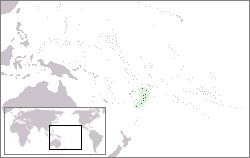
Tongatapu is the main island of Tonga and the site of its capital, Nukuʻalofa. It is located in Tonga's southern island group, to which it gives its name, and is the country's most populous island, with 74,611 residents (2016), 70.5% of the national population, on 260 square kilometres (100 square miles). Based on Google Earth Pro, its maximum elevation is at least 70 metres (230 feet) above sea level along Liku Road at 21 degrees 15 minutes and 55.7 seconds south 175 degrees 08 minutes 06.4 seconds west, but could be even higher somewhere else. Tongatapu is Tonga's centre of government and the seat of its monarchy.
 Satellite picture of Tongatapu | |
 | |
| Geography | |
|---|---|
| Location | Pacific Ocean |
| Coordinates | 21°12′41″S 175°09′11″W |
| Archipelago | Tonga Islands |
| Area | 260.48 km2 (100.57 sq mi) |
| Administration | |
Tonga | |
| Largest settlement | Nukuʻalofa (pop. 23,221) |
| Demographics | |
| Population | 74,454[1] (2021) |
| Pop. density | 273.57/km2 (708.54/sq mi) |
| Ethnic groups | Tongan (majority), European, Chinese, Pacific Islanders. |
Tongatapu has experienced more rapid economic development than the other islands of Tonga, and has thus attracted many internal migrants from them.
Geography
This section does not cite any sources. (May 2017) |
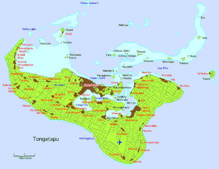
The island is 257.03 square kilometres (99.24 square miles) (or 260.48 square kilometres (100.57 square miles) including neighbouring islands) and rather flat, as it is built of coral limestone. The island is covered with thick fertile soil consisting of volcanic ash from neighbouring volcanoes. At the steep coast of the south, heights reach an average of 35 metres (115 feet), and maximum 70 metres (230 feet), gradually decreasing towards the north.

![Page from the ship's log of Abel Tasman with the description of 't Eijlandt Amsterdam, nowadays Tongatapu [2]](http://upload.wikimedia.org/wikipedia/commons/a/a2/NL-HaNA_1.11.01.01_121_0051_Scheepsjournaal_Abel_Tasman_35.jpg)
North of the island are many small isolated islands and coral reefs which extend up to 7 kilometres (4.3 miles) from Tongatapu's shores. The almost completely closed Fanga'uta and Fangakakau Lagoons are important breeding grounds for birds and fish as they live within the mangroves growing around the lagoon's shores. The lagoons were declared a Natural Reserve in 1974 by the government.[citation needed]
Climate
Tongatapu has a rather cooler climate than the rest of Tonga as it is the southernmost group of islands in the country. Because of this, fruit production is lower in Tongatapu than it is in the warmer islands in the north.
| Climate data for Nukuʻalofa (Köppen Af) | |||||||||||||
|---|---|---|---|---|---|---|---|---|---|---|---|---|---|
| Month | Jan | Feb | Mar | Apr | May | Jun | Jul | Aug | Sep | Oct | Nov | Dec | Year |
| Record high °C (°F) | 32 (90) |
32 (90) |
31 (88) |
30 (86) |
30 (86) |
28 (82) |
28 (82) |
28 (82) |
28 (82) |
29 (84) |
30 (86) |
31 (88) |
32 (90) |
| Average high °C (°F) | 29.4 (84.9) |
29.9 (85.8) |
29.6 (85.3) |
28.5 (83.3) |
26.8 (80.2) |
25.8 (78.4) |
24.9 (76.8) |
24.8 (76.6) |
25.3 (77.5) |
26.4 (79.5) |
27.6 (81.7) |
28.7 (83.7) |
27.3 (81.1) |
| Daily mean °C (°F) | 26.4 (79.5) |
26.8 (80.2) |
26.6 (79.9) |
25.3 (77.5) |
23.6 (74.5) |
22.7 (72.9) |
21.5 (70.7) |
21.5 (70.7) |
22.0 (71.6) |
23.1 (73.6) |
24.4 (75.9) |
25.6 (78.1) |
24.1 (75.4) |
| Average low °C (°F) | 23.4 (74.1) |
23.7 (74.7) |
23.6 (74.5) |
22.1 (71.8) |
20.3 (68.5) |
19.5 (67.1) |
18.1 (64.6) |
18.2 (64.8) |
18.6 (65.5) |
19.7 (67.5) |
21.1 (70.0) |
22.5 (72.5) |
20.9 (69.6) |
| Record low °C (°F) | 16 (61) |
17 (63) |
15 (59) |
15 (59) |
13 (55) |
11 (52) |
10 (50) |
11 (52) |
11 (52) |
12 (54) |
13 (55) |
16 (61) |
10 (50) |
| Average rainfall mm (inches) | 174 (6.9) |
210 (8.3) |
206 (8.1) |
165 (6.5) |
111 (4.4) |
95 (3.7) |
95 (3.7) |
117 (4.6) |
122 (4.8) |
128 (5.0) |
123 (4.8) |
175 (6.9) |
1,721 (67.8) |
| Average rainy days | 17 | 19 | 19 | 17 | 15 | 14 | 15 | 13 | 13 | 11 | 12 | 15 | 180 |
| Average relative humidity (%) | 77 | 78 | 79 | 76 | 78 | 77 | 75 | 75 | 74 | 74 | 73 | 75 | 76 |
| Source: Weatherbase[3] | |||||||||||||
History
People of the Lapita culture
This section does not cite any sources. (May 2017) |
Tongatapu is known as having one of the highest concentration of archaeological remains in the Pacific. The earliest traces of Lapita pottery found in Tonga was from around 900–850 BC, 300 years after the first settlements in Tonga were established. Archaeologist David Burley discovered the pottery around the Fanga'uta Lagoon, 2,000 kilometres (1,200 miles) away from the Lapita pottery found at Santa Cruz in the Solomon Islands.
Tonga was always the seat of the Tuʻi Tonga Empire, but in an area of distances up to 1,000 kilometres (620 miles), it was often only a symbolic rule. From the first capital at Toloa, around 1000 years ago, to the second capital at Heketā, at the site of the Haʻamonga ʻa Maui Trilithon, none boasts more traditional attractions than the third capital at Muʻa (from 1220–1851) with more than 20 royal grave mounds.
Europeans

Tongatapu was first sighted by Europeans on 20 January 1643 by Abel Tasman commanding two ships, the Heemskerck and the Zeehaen commissioned by the Dutch East India Company of Batavia (Jakarta). The expedition's goals were to chart the unknown southern and eastern seas and to find a possible passage through the South Pacific and Indian Ocean providing a faster route to Chile. The expedition set sail from Batavia on 14 August 1642. Tasman named the island "t’ Eijlandt Amsterdam" (Amsterdam Island), because of its abundance of supplies.[4] This name is no longer used except by historians.
Commander James Cook, sailing the British vessel Resolution visited the island on October 2, 1773 by some accounts[5] and by other accounts[6] October 1774, returning again in 1777 , with Omai,[7] whereupon they left some cattle for breeding. These were still flourishing in 1789 when Bounty, under Fletcher Christian visited.
The earliest mention of the name Tongatapu (spelled "Tongataboo" in the text) was by James Cook in 1777, as he wrote his memoirs for the Three Voyages Around the World, Volume 1.
British and American whalers were regular visitors to the island for provisions, water and wood. The first on record was the Hope, in April–May 1807. The last known to have called was the Albatross in November–December 1899.[8]
| Year | Pop. | ±% |
|---|---|---|
| 1976 | 57,411 | — |
| 1986 | 63,794 | +11.1% |
| 1996 | 66,979 | +5.0% |
| 2006 | 72,045 | +7.6% |
| 2011 | 75,416 | +4.7% |
| 2016 | 74,611 | −1.1% |
| 2021 | 74,454 | −0.2% |
| Sources:[9][10][1] | ||
Main sights
- Nukuʻalofa – Capital of Tonga
- Muʻa – Second largest town in Tongatapu. Site of the ancient burial mounds and the Papae 'o Tele'a Tombs.
- Langi – Tombs of Tongan kings
- Hule fortress – Located in Nukunuku - Kolotau Ko Hule - Western District of Tongatapu
- Mapu ʻa Vaea – Blowholes in the coral reef on the south-western side
- Hūfangalupe – Natural landbridge on the south eastern side of Tongatapu
- Pangaimotu – Small resort island close to Nukuʻalofa
- Landing site of Captain Cook
- Flying Fox Preserve – Located in Kolovai in the western side Taungapeka
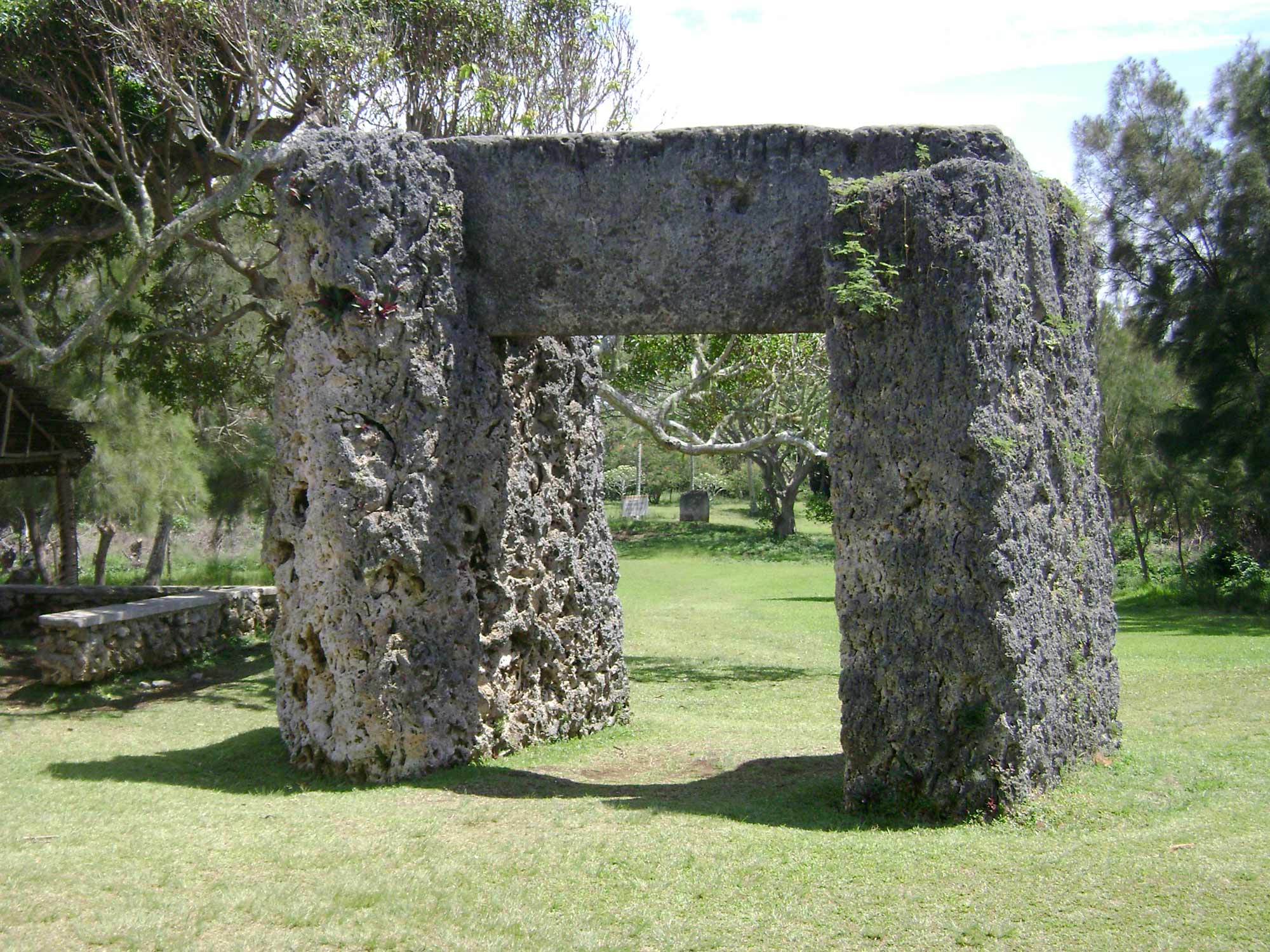
- Haʻamonga ʻa Maui – Trilithon
- Nukuleka – possibly the site of first Lapita settlement in Tonga
- Tupou College – first educational establishment in the kingdom located in the eastern district of Tongatapu near Malapo
See also
References
- "Tonga's population drops to 100,209". Matangi Tonga. 24 December 2021. Archived from the original on 24 December 2021. Retrieved 24 December 2021.
- Nationaal Archief, archiefinventaris 1.11.01.01 inventarisnummer 121, scan 85 hdl:10648/877f659e-35ce-4059-945e-294a4d05d29c
- "Nuku'alofa Climate Info". Weatherbase. Retrieved 4 November 2012.
- Hooker, Brian (2013). "The European Discovery of the Tonga Islands". Terrae Incognitae. 36: 20–27. doi:10.1179/tin.2004.36.1.20. S2CID 140737896.
- "The Kingdom Of Tonga | Three Millennia of History". www.thekingdomoftonga.com. Retrieved 2018-05-15.
- "A Cook's Tour of Tonga". The Captain Cook Society (CCS). Retrieved 2018-05-15.
- Salmond, Anne (2010). Aphrodite's Island. Berkeley: University of California Press. pp. 291, 412. ISBN 9780520261143.
- Langdon, Robert (ed.) (1984), Where the whalers went: an index to the Pacific Islands visited by American whalers (and some other ships) in the 19th century, Canberra, Pacific Manuscripts Bureau, p.238-9. ISBN 086784471X
- "1996 Tonga Census Administrative Report". Tonga Department of Statistics. p. xii. Retrieved 30 December 2021.
- "Census". Tonga Statistics Department. Retrieved 30 December 2021.
External links
- Tonga Quick Facts
- Photographs from Tongatapu, Tonga
- The European discovery of the Tonga Islands Archived 2012-04-20 at the Wayback Machine by Brian Hooker
Authority control | |
|---|---|
| General |
|
| National libraries | |
| Other | |
На других языках
[de] Tongatapu
Tongatapu ist die größte und mit gut 74.600 Einwohnern (Stand 2016[1]) auch bevölkerungsreichste Insel des Königreichs Tonga. 23.658 Menschen wohnten zur Volkszählung 2006 in Nukuʻalofa, der größten Stadt Tongatapus und Hauptstadt von Tonga, und 34.311 in der Agglomeration. Über den internationalen Flughafen Fuaʻamotu und den Hafen in Nukuʻalofa kann die Insel erreicht werden. Die Insel gibt ihren Namen auch der umliegenden Inselgruppe und Verwaltungseinheit.- [en] Tongatapu
[es] Tongatapu
Tongatapu es la principal isla de Tonga, donde está la capital Nukualofa, y la residencia del rey de Tonga, Tupou VI.[fr] Tongatapu
Tongatapu est la plus grande[1] des 150 îles du royaume des Tonga, qui constituent un archipel du Pacifique. C'est l'île la plus peuplée des Tonga avec plus de 70 000 habitants en 2006. Elle abrite les institutions du gouvernement tongien et c'est là que réside le roi des Tonga. C'est également le poumon économique du pays, et de nombreux Tongiens émigrent des autres îles pour venir travailler à Nuku'alofa, la capitale.[it] Tongatapu
Tongatapu è una divisione delle Tonga con 74 454 abitanti al censimento 2021.[1] Il capoluogo è Nukuʻalofa, anche capitale del Regno di Tonga.[ru] Тонгатапу
Тонгата́пу[1] (англ. Tongatapu) — крупнейший остров в группе Тонгатапу архипелага Островов Тонга (или Острова Дружбы) в юго-западной части Тихого океана. По происхождению — поднятый атолл. Площадь островов — 260,48 км² (остров Тонгатапу — 257,03 км²), население — 72 045 человек[2] (2006). На острове находится город Нукуалофа (столица королевства Тонга) и Международный аэропорт Фуаамоту.Другой контент может иметь иную лицензию. Перед использованием материалов сайта WikiSort.org внимательно изучите правила лицензирования конкретных элементов наполнения сайта.
WikiSort.org - проект по пересортировке и дополнению контента Википедии