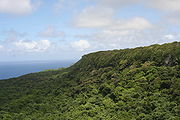
 'Eua National Park, looking south, on the Eastern side of 'Eua
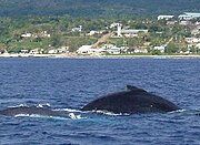 Humpback whales with Ohonua in the background
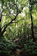 Forest in 'Eua
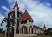 Church on 'Eua
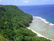 Forested cliffs on 'Eua
geo.wikisort.org - Island
ʻEua [ʔe.ˈu.a] is an island in the kingdom of Tonga. It is close to Tongatapu, but forms a separate administrative division. It has an area of 87.44 km2 (33.76 sq mi), and a population in 2021 of 4,903 people.
 | |
| Geography | |
|---|---|
| Location | Pacific Ocean |
| Coordinates | 21°23′S 174°56′W |
| Archipelago | Tonga Tapu Islands |
| Total islands | 2 |
| Major islands | 1 |
| Area | 87.44 km2 (33.76 sq mi) |
| Highest elevation | 312 m (1024 ft) |
| Highest point | Funga Fonua |
| Administration | |
Tonga | |
| Vaka'uta | KVL |
| Largest settlement | 'Ohonua |
| Demographics | |
| Population | 4,903[1] (2021) |
| Pop. density | 60.04/km2 (155.5/sq mi) |
| Ethnic groups | Tongan (majority), European, Chinese, Pacific Islanders |


Geography
ʻEua is a hilly island, the highest peaks are the Teʻemoa (chicken manure) 312 m, and the Vaiangina (watersprings) 305 m. The island is not volcanic, but was shaped by the rubbing of the Tonga Plate against the Pacific Plate, pushing ʻEua up and leaving the 7-kilometre-deep (4.3 mi) Tonga Trench on the bottom of the ocean, a short distance towards the east. The soil of ʻEua is volcanic, as is that of Tongatapu, but only the top layer, deposited by eruptions of nearby volcanoes ten thousands years ago. Under it are the solid rocks of pushed-up coral. ʻEua counts many huge caves and holes, not all of which have yet been explored.
ʻEua and Niuatoputapu are the only islands in Tonga that have streams, and ʿEua had the only bridge in the kingdom until Vavaʻu also built one.[2] The stream drains into the harbour near the capital of the island, ʻOhonua.
A unique feature is the shore between ʻOhonua and Tufuvai. It is coral reef still close to the sea level. Many small tidal pools are found, named the ʻotumatafena.
It is served by ʻEua Airport, which has an unsealed coral runway.
Myths
Together with ʻAta, ʻEua was the first island to be created by Tangaloa, see Tangaloa And The Story Of How ‘Eua Island Was Created.[3]
History
ʻEua was put on the European maps by Abel Tasman who reached it and Tongatapu on 21 January 1643. He called it Middelburg Island, after the Dutch city of Middelburg, Zeeland. He did not go on land, but proceeded to the Hihifo district of Tongatapu, which he named Amsterdam Island after the capital of the Netherlands.
'Eua was considered by early Missionaries as heathen as it was the rendezvous for whalers, a place that you can trade goods for guns, knives, axes and gunpowder. aka arsenal, or armory of Tonga, as well as its granary.
Captain James Cook visited the island in 1773 and 1777. On his map, it is named Eaoowe.[4]
Administration
ʻEua is divided into two districts
- 'Eua Motu'a (Old 'Eua), in the north, with six villages and population of 2,771.
- 'Eua Fo'ou (New 'Eua), in the south, with 2,132 inhabitants in nine villages.
The nine villages of the southern district 'Eua Niuafo'ou (or 'Eua Fo'ou for short) were founded by people who had to leave their island of Niuafo'ou in 1946 due to a volcanic eruption; they are all named after villages of Niuafo'ou.
The northern district in contrast is Old 'Eua. The southern village of Kolomaile's inhabitants however are descendants of the former inhabitants of the island of ʻAta, Tonga's southernmost island, evacuated after the island was targeted by slavers.
3.8 kilometres (2.4 miles) south-west of the southern tip of 'Eua (Lakufaanga) is the 35-acre island Kalau.
Demography
| Year | Pop. | ±% |
|---|---|---|
| 1976 | 4,486 | — |
| 1986 | 4,393 | −2.1% |
| 1996 | 4,934 | +12.3% |
| 2006 | 5,206 | +5.5% |
| 2011 | 5,016 | −3.6% |
| 2016 | 4,945 | −1.4% |
| 2021 | 4,903 | −0.8% |
| Sources:[5][6][1] | ||
The villages of the original inhabitants of ʻEua are all in the north Houma, Taʻanga, ʻOhonua, Pangai, Tufuvai.
Haʻatuʻa and Kolomaile are from the original inhabitants from ʻAta, who were resettled there in 1863. The villages just north of that up to Angahā, are from the inhabitants of Niuafoʻou who were resettled there in 1946.
Ecology
ʻEua is the only habitat of the koki (Prosopeia tabuensis) in Tonga.[7]: 4 It supports 12 species of birds, nine of lizards, and two bats, the Insular flying fox and Pacific sheath-tailed bat.[7]: 9 Bird species include the Buff-banded rail, Pacific imperial pigeon, Crimson-crowned fruit dove, White-rumped swiftlet, Collared kingfisher, Polynesian starling, Polynesian triller and Polynesian wattled honeyeater.[8] Reptiles include the Oceanic gecko, mourning gecko and blue-tailed skink.[8]
Culture
The 2014 film When the Man Went South was mostly filmed on ʻEua.[9]
Gallery


See also
- 'Eua National Park
References
Wikivoyage has a travel guide for ʻEua.
- "Tonga's population drops to 100,209". Matangi Tonga. 24 December 2021. Archived from the original on 24 December 2021. Retrieved 24 December 2021.
- Encyclopædia Britannica – Tonga
- "Tangaloa". Archived from the original on 2011-07-10. Retrieved 2009-09-18.
- Salmond, Anne (2010). Aphrodite's Island. Berkeley: University of California Press. pp. 291-292, 417. ISBN 9780520261143.
- "1996 Tonga Census Administrative Report". Tonga Department of Statistics. p. xii. Retrieved 30 December 2021.
- "Census". Tonga Statistics Department. Retrieved 30 December 2021.
- Saafi, Elizabeth Patisepa Kiteau (2002). Ecology and conservation of koki (Prosopeia tabuensis) in Tonga (MSc). Massey University. Retrieved 1 January 2022.
- Gill, B. J. (1987). "NOTES ON THE BIRDS, REPTILES AND MAMMALS OF TONGATAPU AND 'EUA (TONGA)" (PDF). Notornis. 34: 217–223. Retrieved 11 August 2022.
- "Sample Article".
External links
- eua-island-tonga.com (Archived 2009-04-18)
Authority control | |
|---|---|
| General | |
| National libraries | |
На других языках
[de] ʻEua
ʻEua gehört zu der Inselgruppe Tongatapu im Königreich Tonga. Es liegt zirka 40 km südöstlich von der Hauptinsel Tongatapu und ist eine der ältesten Inseln im Pazifik.- [en] ʻEua
[es] 'Eua
‘Eua es una isla de Tonga, la isla hermana de Tongatapu situada a 18 km al sureste. Pero comprende una forma separada de división administrativa.[fr] ʻEua
‘Eua est une île des Tonga. Elle est située à 18 kilomètres au sud-est de l'île de Tongatapu (où se trouve la capitale du pays, Nuku'alofa). À la différence de beaucoup d'autres îles de la région, ’Eua est un ensemble volcanique au relief accentué. Son point culminant est le mont Teʻemoa (383 mètres).[it] 'Eua
'Eua è un'isola ed una divisione delle Tonga con 4 903 abitanti al censimento 2021.[1] Il capoluogo è 'Ohonua.[ru] Эуа
Эуа (тонг. ʻEua) — остров в архипелаге Тонга в 18 км к юго-востоку от острова Тонгатапу (Королевство Тонга).Текст в блоке "Читать" взят с сайта "Википедия" и доступен по лицензии Creative Commons Attribution-ShareAlike; в отдельных случаях могут действовать дополнительные условия.
Другой контент может иметь иную лицензию. Перед использованием материалов сайта WikiSort.org внимательно изучите правила лицензирования конкретных элементов наполнения сайта.
Другой контент может иметь иную лицензию. Перед использованием материалов сайта WikiSort.org внимательно изучите правила лицензирования конкретных элементов наполнения сайта.
2019-2026
WikiSort.org - проект по пересортировке и дополнению контента Википедии
WikiSort.org - проект по пересортировке и дополнению контента Википедии