geo.wikisort.org - Island
The Holm of Scockness is a small island in the Orkney Islands, between Rousay and Egilsay.
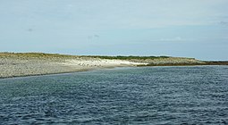
 A sandy bay at the south-east corner of Holm of Scockness | |
| Location | |
|---|---|
| OS grid reference | HY456313 |
| Coordinates | 59.17°N 2.95°W |
| Physical geography | |
| Island group | Orkney |
| Administration | |
| Sovereign state | United Kingdom |
| Country | Scotland |
| Council area | Orkney Islands |
| Demographics | |
| Population | 0 |
It is currently used for grazing.
Its name is Norse in origin and means "little island of the crooked headland".[1]
Geography and geology
The bedrock is middle red sandstone like the neighbouring islands.[1]
It is similar to a map of India in shape, "pointing" southwards.
It is in the north of Rousay Sound, and separated from Rousay itself by the Sound of Longstaing, and from Egilsay by Howie Sound. It is south west of Kili Holm and due north of Wyre's far east coast.
References
- Haswell-Smith, Hamish (2004). The Scottish Islands. Edinburgh: Canongate. ISBN 978-1-84195-454-7.
Wikimedia Commons has media related to Holm of Scockness.
На других языках
- [en] Holm of Scockness
[fr] Holm of Scockness
Holm of Scockness est une île du Royaume-Uni située dans l'archipel des Orcades en Écosse.[it] Holm of Scockness
Holm of Scockness è un isolotto disabitato delle Orcadi, attualmente usato per il pascolo del bestiame. Il suo nome deriva dalla lingua norrena, e significa "isolotto del promontorio storto".Текст в блоке "Читать" взят с сайта "Википедия" и доступен по лицензии Creative Commons Attribution-ShareAlike; в отдельных случаях могут действовать дополнительные условия.
Другой контент может иметь иную лицензию. Перед использованием материалов сайта WikiSort.org внимательно изучите правила лицензирования конкретных элементов наполнения сайта.
Другой контент может иметь иную лицензию. Перед использованием материалов сайта WikiSort.org внимательно изучите правила лицензирования конкретных элементов наполнения сайта.
2019-2025
WikiSort.org - проект по пересортировке и дополнению контента Википедии
WikiSort.org - проект по пересортировке и дополнению контента Википедии
