geo.wikisort.org - Island
Great Cumbrae (Scots: Muckle Cumbrae; Scottish Gaelic: Cumaradh Mòr; also known as Great Cumbrae Island,[6] Cumbrae or the Isle of Cumbrae) is the larger of the two islands known as The Cumbraes in the lower Firth of Clyde in western Scotland. The island is sometimes called Millport, after its main town.
This article uses bare URLs, which may be threatened by link rot. (August 2022) |
| Scottish Gaelic name | Cumaradh Mòr |
|---|---|
| Scots name | Muckle Cumbrae |
| Old Norse name | Kumrey |
| Meaning of name | Large island of the Cymric people[1] |
| Location | |
 Great Cumbrae Great Cumbrae shown within Argyll and Bute | |
| OS grid reference | NS169566 |
| Coordinates | 55.77°N 4.92°W |
| Physical geography | |
| Island group | Firth of Clyde |
| Area | 1,168 ha (4.5 sq mi) |
| Area rank | 45 [2] |
| Highest elevation | The Glaidstane 127 metres (417 ft) |
| Administration | |
| Sovereign state | United Kingdom |
| Country | Scotland |
| Council area | North Ayrshire |
| Demographics | |
| Population | 1,376[3] |
| Population rank | 10 [2] |
| Population density | 117.8/km2 (305/sq mi)[3][4] |
| Largest settlement | Millport |
| References | [4][5] |
Home to the Cathedral of The Isles and the FSC Millport field study centre, the island has a thriving community of 1,300 residents.
Geography
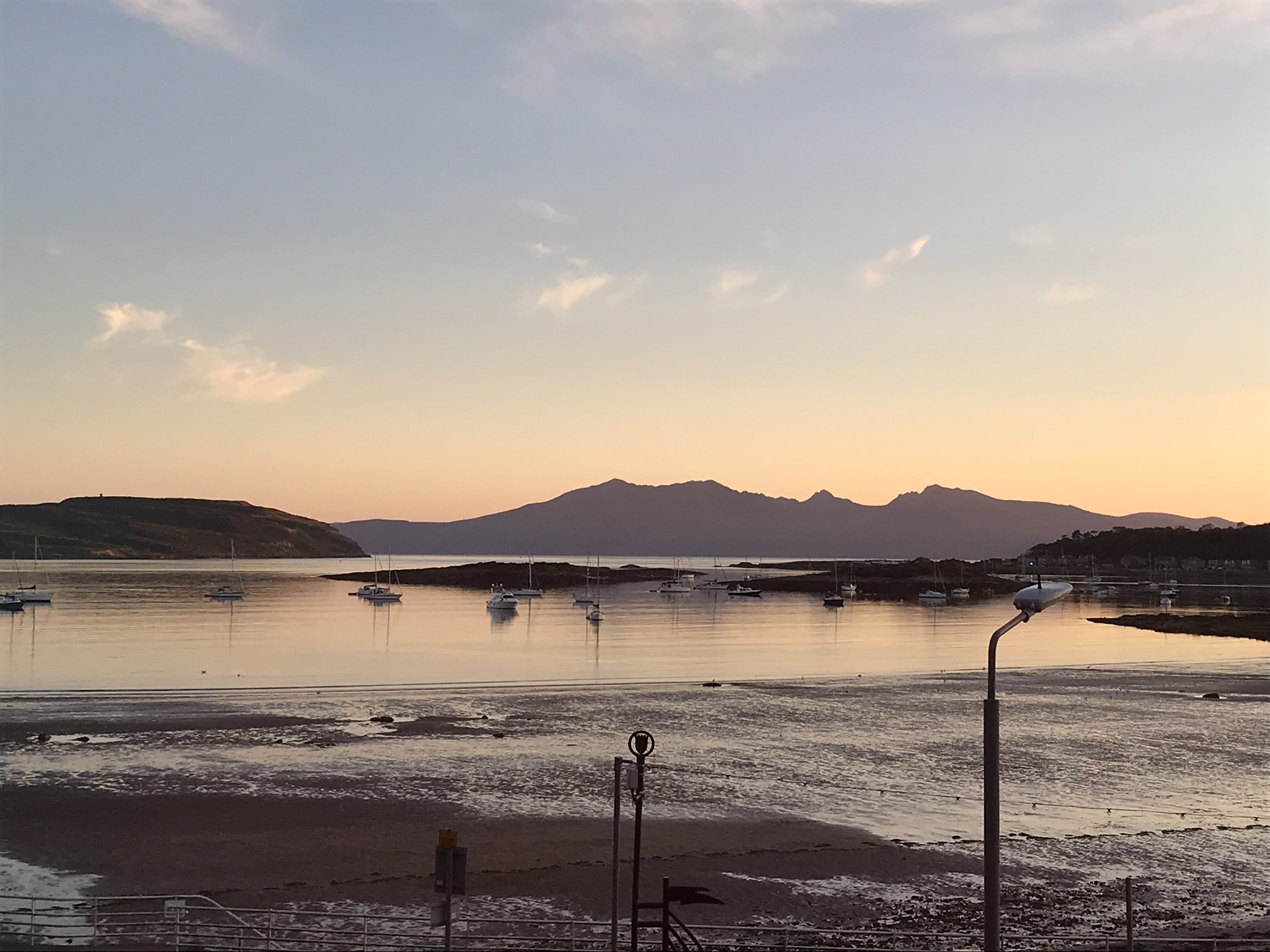
The island is roughly 4 kilometres (2+1⁄2 mi) long by 2 kilometres (1+1⁄4 mi) wide, rising to a height of 127 metres (417 ft) above sea level at The Glaid Stone, which is a large, naturally occurring rock perched on the highest summit on the island.[5] There is a triangulation pillar nearby, as well as an orientation point which indicates the locations of surrounding landmarks.
In clear conditions, views extend north over the upper Clyde estuary to Ben Lomond and the Arrochar Alps. To the west, the larger islands of Bute and Arran can be seen, while on the other side of Knapdale the Paps of Jura may be visible. Looking south, Ailsa Craig is visible, around 40 mi (60 km) distant beyond Little Cumbrae. Ailsa Craig roughly marks the halfway point to Northern Ireland, which itself may be glimpsed if visibility is good. To the east, the views are not so extensive, being restricted by the higher ground of the Renfrew Hills only a few miles distant, however the town of Largs and village of Fairlie and the deep water coal terminal and power station at Hunterston can be seen.
Millport, the island's only town, is spread around a bay which makes up the entire south coast of the island.
The land on the island is primarily owned by the farmers, with the other major land owner being the Millport Golf Club.
Etymology
The Gaelic name Cumaradh means "place of the Cymric people", referring to the Brittonic-speaking inhabitants of the Kingdom of Strathclyde.[1] The Cumbraes are referred to as the Kumreyjar in the Norse Saga of Haakon Haakonarson.[7] The island was previously known in English as Great or Greater Cumray.[4]
Geology
The island is formed largely from sandstones and mudstones of late Devonian and early Carboniferous age. This sedimentary bedrock is cut by numerous northeast–southwest aligned igneous dykes intruded during the Carboniferous period. Further dykes were intruded during the Palaeogene period, cutting across the earlier ones in a north–south to NNW-SSE in orientation. One of the latter is responsible for the 10m high roadside rock formation known as Lion Rock in the southeast of the island.[8] Several geological faults cut both the country rock and the dykes, the most significant being the north–south aligned Kames Bay Fault which extends from White Bay in the north to the bay from which it derives its name in the south.
The youngest sedimentary rocks are the sandstones forming 'The Eileans' in Millport Bay whilst the Kelly Burn Sandstone is the oldest. In stratigraphical order (i.e. youngest at the top), the sequence is:
- Inverclyde Group
- Clyde Sandstone Formation
- Eileans Sandstone Member
- Millport Cornstones Member
- Ballagan Formation
- Kinnesswood Formation
- Foulport Sandstone Member
- Doughend Sandstone Member
- Clyde Sandstone Formation
- Stratheden Group
- Kelly Burn Sandstone Formation
The Doughend Sandstone (named from the westernmost reach of the island) unconformably overlies the Kelly Burn Sandstone; both are of late Devonian age whilst the rest of the sequence is of Carboniferous age.
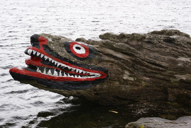
Various of the rock formations have become popular with tourists, including Crocodile Rock, Indian's Face, Lion Rock and Queen Victoria's Face. Several have been enhanced with colourful paint.
A raised beach is developed around almost the whole of the island at about 8m above current sea level. Vegetated spreads of sand, shingle and boulders occur locally across this platform. Wider in the west, it has been exploited by the B896 coastal road. The island's highest waterfall, Horse Falls, plunges over the old sea cliffs at Bell Bay. A higher raised beach is covered by marine deposits inland of Millport Bay and in the northeast of the island. Inland are traces of till deposited by the glacial ice which over-ran the island during the last ice age. Small areas of peat, alluvium and blown sand are also present in places.[9]
History
The island has been inhabited since the end of the last ice age.
Legend has it that St Mirin, on his return to Scotland from Ireland around AD 710, arrived in Cumbrae and, following the example of St Patrick, rid the island of snakes. The Cathedral of the Isles is reputed to have been built on the site where St Mirin preached. Cumbrae to this day remains snake-free. St Mirin then founded a community in Paisley.
In 1263, Haakon IV, King of Norway, may have used the eastern coast of the island as an anchorage for his fleet, before the inconclusive Battle of Largs. Ballochmartin Bay and Portrye (derived from Gaelic elements meaning "king's harbour") are suggested locations for the Norwegian-anchorage.[10]
Cumbrae has long been linked to Christianity in Scotland. At one time the island had many standing stones. The Aberdeen Breviary of 1509, printed in Edinburgh, tells of two of the island's early female missionaries, Saints Baya and Maura. In 1549 Dean Monro wrote of "Cumbra" that it was "inhabit and manurit, three myle in lenth and ane myle in breadthe, with ane kirk callit Sanct Colmis kirke".[11]
For many centuries the island was under shared ownership, with the Marquess of Bute in the west and the Earl of Glasgow in the east. In 1999 the final feudal landowner, Le Mans winner Johnny Dumfries, now Bute, of Mount Stuart House, put the island up for general sale, with first refusal given to his farmer tenants.
Tourism grew in the 20th century, and Millport became a popular stop for Clyde steamers and families going 'Doon the Watter for the Fair' (Glasgow Fair holidays). It is possible to experience a traditional day out on the PS Waverley which operates from both Glasgow and Ayr during the summer.
The University Marine Biological Station Millport (UMBSM) was run by the Universities of Glasgow and London. Founded in 1885 by Sir John Murray and David Robertson, attracted UK and foreign students throughout the academic year. In May 2003, in the presence of Princess Anne, the station took delivery of the Macduff-built, 22-metre (72-foot) marine Research Vessel Aora. UMBSM also functioned as a Met Office Weather Station and Admiralty Tide Monitor.[12] The station closed in October 2013 and the site, just outside town, has been refurbished and run by the Field Studies Council since 2014.[13]
The island was home to the National Watersports Centre which closed in 2020.[14]
Residents
The usual island population of 1,376[3] as recorded by the 2011 census was a slight fall from the 2001 figure of 1,434. The population increases substantially during the summer tourist season.
The island has an active and engaged community [15] with a wide range of interest groups represented in the many clubs and associations on the island. The Guardian reported that Cumbrae was number 8 in British online property searches in 2021, attributing this to the effect of the COVID-19 lockdown then in force.[16]
It is estimated that the 2018 economic output of the island was £10.2 million, of which 30% came from the health sector. Total employment was estimated at 400, of which a third worked in the health sector and a quarter in tourism-related sectors.[citation needed]
Governance
The community is represented by The Cumbrae Community Council. Council members are elected by the residents, and all groups and individuals on the island are invited to its monthly meetings.[17] The community council provides a connection with North Ayrshire council, and its members are formal members of Locality Planning Partnerships.[18]
Tourism

During the summer, the population grows by several thousand every weekend. Hiring a bike and cycling around the island's 11-mile (18-kilometre) encircling coastal road is a popular activity for visitors, as the roads are quiet compared to the mainland. There are informal walks all over the island. Fintry Bay, around 3 mi (5 km) from Millport on the west coast, has a small cafe.
Millport Bay, with visitor moorings, is a popular destination for sailors in the summer. The most dived site on the Clyde is just south of the ferry slip; a Second World War Catalina flying boat.
There is a curling pond near the highest point on the island, in January 2010 it hosted the Dumfries Cup for the first time in 14 years, and in December of the same year it was also available for public use.
Other attractions include:
- Cathedral of The Isles – William Butterfield, one of the great architects of the Gothic revival designed the cathedral church of the Diocese of Argyll and the Isles, within the Episcopal Church of Scotland (Anglican Communion). George Frederick Boyle, 6th Earl of Glasgow acted as the founder and benefactor. Construction finished in 1849 and the cathedral opened in 1851. Formal gardens and woodland surround the cathedral, the highest building on Great Cumbrae and one of the smallest cathedrals in Europe.[19]
- College of the Holy Spirit, also known as Cumbrae Theological College – attached to the cathedral, this former seminary for ordination training is now a Retreat House and the Argyll Diocesan Conference Centre. The college was founded by Boyle in 1849 and was affiliated to the University of Durham during the 1860s.[20] The College closed in 1888 and the building was later used for other purposes. It was the base for The Community of Celebration, or Fisherfolk, an international group of artists and musicians sharing a Benedictine lifestyle during the 1970s and the 1980s.
- The Wedge – a private residence which has the smallest frontage in the UK; the width of a front door.
- Museum of the Cumbraes occupies part of the Garrison, built originally for the captain of an anti-smuggling revenue cutter.
- FSC Millport – has an aquarium of sea creatures from the Firth of Clyde, and a museum which tells the story of the sea and of the Clyde area, which is open daily. The FSC refurbished the existing facilities of the Marine Biological Station and created two additional blocks, one for accommodation and one for conferences.
Transport
A Caledonian MacBrayne car ferry connects the island with Largs, Ayrshire on the Scottish mainland. Millport pier dates from 1833 and that at Largs from 1845.[21][22]
Millport was served by Clyde steamers until the 1960s. Largs is now a regular calling point for PS Waverley.[22] For nearly 20 years from 1967, passenger ferry, MV Keppel crossed to Millport pier. In early April 1977, car ferry MV Isle of Cumbrae took up the crossing to Cumbrae Slip and continued until the sisters MV Loch Striven and MV Loch Linnhe arrived in the summer of 1986.[23] A larger ferry, MV Loch Shira, built at Ferguson Shipbuilders in Port Glasgow,[24] entered service on 2 June 2007. At peak times, she is partnered by one of the original Loch class vessels.
| Preceding station | Ferry | Following station | ||
|---|---|---|---|---|
| Terminus | Caledonian MacBrayne Ferry |
Largs |
Marine environment and wildlife
Cumbrae has a marine climate and can experience gale-force winds from the Atlantic at any time of year; these westerly or south-westerly gales can be severe and destructive. However, while the west of the island might experience gales up to 70 mph (110 km/h), the weather on the sheltered east side facing Largs can remain tranquil.
Local wildlife includes owls, polecats, rabbits, common kestrels and the occasional golden eagle and sea eagle, as well as a large seabird population: northern fulmars, great cormorants, Eurasian oystercatchers and many more.[25] Other marine life includes seals, basking sharks, porbeagle sharks and dolphins.
Environmental issues
Cumbrae lies close to two nuclear power stations - Hunterston A (being de-commissioned) and Hunterston B near Fairlie (Magnox and Advanced gas-cooled reactor respectively). A wind farm lies behind Hunterston B on Busbie Muir, above West Kilbride. It contains twelve 100-metre-high (330-foot) turbines, which can be seen from Cumbrae, especially in early morning and late evening light.
The waters nearby are also host to the UK's nuclear deterrent, Vanguard-class submarines carrying Trident missiles, from HM Naval Base at Faslane/Coulport, further up the Clyde.
Current developments

- A flood protection scheme is in development for the southern part of the island.[26]
- A marina is proposed as part of the flood protection scheme works.
- A new town hall is in development.[27]
- A proposal is underway to buy the former National Watersports Centre and make it into a community facility called The Wave.[28]
Commonwealth Games – Glasgow 2014
The Commonwealth Torch used in the Queen's Baton Relay for the 2014 Commonwealth Games in Glasgow was crafted using locally-sourced elm wood from the garrison grounds in Millport.
Notable residents
- Duncan Macrae (actor and comedian, Whisky Galore, The Prisoner)[29]
- Stephens Orr (society photographer)
- David Robertson (naturalist)[30]
- The Saxon (a Clyde puffer which provided a shipping service to the island) and which featured in the TV series The Vital Spark, based on Neil Munro's Para Handy stories about the Vital Spark.
Media and the arts
The island was featured in the BBC Radio 4 comedy series, Millport, written by and starring Lynn Ferguson.
The island was the focus of a BBC documentary called Seaside Stories which featured many local businesses and residents.
The island also featured in childrens TV programme My Story shown on CBeebies in 2012.
See also
- Millport, Cumbrae
- List of islands of Scotland
- Little Cumbrae Castle
Footnotes
- Mac an Tàilleir p. 36
- Area and population ranks: there are c. 300 islands over 20 ha in extent and 93 permanently inhabited islands were listed in the 2011 census.
- National Records of Scotland (15 August 2013). "Appendix 2: Population and households on Scotland's Inhabited Islands" (PDF). Statistical Bulletin: 2011 Census: First Results on Population and Household Estimates for Scotland Release 1C (Part Two) (PDF) (Report). SG/2013/126. Retrieved 14 August 2020.
- Haswell-Smith (2004) pp. 18-20
- Ordnance Survey. OS Maps Online (Map). 1:25,000. Leisure.
- "Great Cumbrae Island". Ordnance Survey. Retrieved 7 February 2019.
- "cömbröɣ" Archived 20 March 2012 at the Wayback Machine "Brittonic Language in the Old North". Scottish Place-Name Society. Retrieved 14 September 2011.
- "Lion Rock". Archived from the original on 1 August 2015.
- British Geological Survey 2008. Dunoon and Millport, Scotland sheet 29E with part of 21E. Bedrock and superficial deposits . 1:50,000. (Keyworth, Nottingham: BGS)
- Alexander, Derek; Neighbour, Tim; Oram, Richard D. (2000). "Glorious Victory? The Battle of Largs, 2 October 1263". History Scotland. Vol. 2, no. 2. pp. 17–22.
- Monro (1549) No. 8
- "About UMBSM". University of Glasgow. Archived from the original on 5 July 2013. Retrieved 11 September 2010.
- "FSC Millport". Field Studies Council. Retrieved 30 September 2020.
- "National sailing centre on Cumbrae to close this year". BBC News. 6 March 2020. Retrieved 30 September 2020.
- "Home". www.cumbrae.org. Retrieved 27 February 2022.
- "Escape to the country? The top 10 UK property searches in 2021". The Guardian. 12 January 2022. Retrieved 27 February 2022.
- "About CCC". cumbrae.org. Retrieved 27 February 2022.
- "Community Council (North Coast)". North Ayrshire Community Planning Partnership. Retrieved 27 February 2022.
- The building is variously described as "the smallest cathedral in Europe", "the second smallest in Europe" etc. See for example "Millport Musings" (19 November 2005) BBC. Retrieved 11 May 2008, "About Cumbrae" Westbourne House. Retrieved 11 May 2008. Various other churches such as the cathedrals in Nin and Zadar in Croatia lay claim to this title.
- "MS 54 College and Collegiate Church of The Holy Spirit, Isle of Cumbrae". Archive Services Online Catalogue. University of Dundee. Retrieved 15 December 2017.
- The Third Statistical Account of Scotland. 1962. p. 537.
- "Largs pier could put Waverley up the creek without a paddle". The Herald. Glasgow. 27 June 2009. Retrieved 11 September 2010.
- McCrorie, Ian (2006). CalMac Ferries. Caledonian MacBrayne. ISBN 978-0-9507166-7-1.
- "MV Loch Shira". Calmac. Retrieved 6 April 2007.
- "Where to Watch Birds in Ayrshire". Archived from the original on 30 September 2007. Retrieved 6 April 2007.
- "Millport Coastal FPS".
- https://millporttownhall.co.uk/
- https://www.thecumbraewave.org/
- Scottish Daily Record. "Millport.(Town of the Week)". Retrieved 10 December 2005.
- "David Robertson". gashe.ac.uk. Retrieved 4 March 2007.
References
- Haswell-Smith, Hamish (2004). The Scottish Islands. Edinburgh: Canongate. ISBN 978-1-84195-454-7.
- Iain Mac an Tàilleir. "Placenames" (PDF). Pàrlamaid na h-Alba. Archived from the original (PDF) on 17 March 2007. Retrieved 23 July 2010.
- Monro, Sir Donald (1549) Description of the Western Isles of Scotland. William Auld. Edinburgh - 1774 edition.
External links
|  | ||||||||||||||||
|
| |||||||||||||||||
| |||||||||||||||||
| |||||||||||||||||
| |||||||||||||||||
| |||||||||||||||||
| |||||||||||||||||
| |||||||||||||||||
Authority control | |
|---|---|
| General |
|
| Other |
|
На других языках
[de] Great Cumbrae
Great Cumbrae (Schott.-gäl. Cumaradh Mòr) oder Isle of Cumbrae (es gibt eine kleine Schwesterinsel namens Little Cumbrae Island) ist eine kleine Insel im Firth of Clyde an der schottischen Westküste, rund 20 Fährminuten von Largs entfernt.- [en] Great Cumbrae
[es] Great Cumbrae
La isla Great Cumbrae (en gaélico escocés, Cumaradh Mòr), también conocida simplemente como Cumbrae o isla de Cumbrae, es la mayor de las dos islas conjuntamente conocidas como The Cumbraes en el Fiordo de Clyde, al oeste de Escocia. La isla alberga el National Watersports Centre ("Centro nacional de deportes acuáticos"), la Catedral de las Islas y la University Marine Biological Station ("Estación universitaria de biología marina") en Millport; también hay un campo de golf que se extiende hasta casi la cima de la isla, y una carretera que la rodea y que es muy propicia para excursiones turísticas y familiares.[fr] Great Cumbrae
Great Cumbrae (en gaélique écossais Cumaradh Mòr) est une île du Royaume-Uni située en Écosse. C'est la plus grande des deux îles connues sous le nom cumbraes dans le Firth of Clyde.[it] Great Cumbrae
Great Cumbrae (in gaelico scozzese: Cumaradh Mòr), conosciuta anche come Isola di Cumbrae (Isle of Cumbrae) o semplicemente come Cumbrae[1][2], è un'isola di 4,5 km² della Scozia nord-occidentale, situata nel Firth of Clyde e facente parte dell'arcipelago di The Cumbraes. È la più estesa delle due isole che compongono tale arcipelago.Другой контент может иметь иную лицензию. Перед использованием материалов сайта WikiSort.org внимательно изучите правила лицензирования конкретных элементов наполнения сайта.
WikiSort.org - проект по пересортировке и дополнению контента Википедии