geo.wikisort.org - Island
The island of Hokkaidō is located in the north of Japan, near Russia (Sakhalin Oblast). It has coastlines on the Sea of Japan (to the west of the island), the Sea of Okhotsk (to the north), and the Pacific Ocean (to the east). The center of the island is mountainous, with volcanic plateaux. Hokkaidō has multiple plains such as the Ishikari Plain 3,800 km2 (1,500 sq mi), Tokachi Plain 3,600 km2 (1,400 sq mi), the Kushiro Plain 2,510 km2 (970 sq mi) (the largest wetland in Japan) and Sarobetsu Plain 200 km2 (77 sq mi). Hokkaidō is 83,423.84 km2 (32,210.12 sq mi) which make it the second-largest island of Japan.
Native name: 北海道 | |
|---|---|
 | |
| Geography | |
| Location | East Asia |
| Coordinates | 43°N 142°E |
| Archipelago | Japanese archipelago |
| Area | 77,981.87 km2 (30,108.97 sq mi) |
| Highest elevation | 2,290 m (7510 ft) |
| Highest point | Mount Asahi |
| Administration | |
Japan | |
| Prefectures | Hokkaidō |
| Largest settlement | Sapporo (pop. 1,890,561) |
| Demographics | |
| Population | 5,377,435 (September 30, 2016) |
| Pop. density | 64.5/km2 (167.1/sq mi) |
| Ethnic groups | Ainu Japanese |
The Tsugaru Strait separates Hokkaidō from Honshu (Aomori Prefecture);[1] La Pérouse Strait separates Hokkaidō from the island of Sakhalin in Russia; Nemuro Strait separates Hokkaidō from Kunashir Island in the Russian Kuril Islands.
The governmental jurisdiction of Hokkaidō incorporates several smaller islands, including Rishiri, Okushiri Island, and Rebun. (By Japanese reckoning, Hokkaidō also incorporates several of the Kuril Islands.) Hokkaidō Prefecture is the largest and northernmost Japanese prefecture. The island ranks 21st in the world by area.
Ecology
Flora and fauna
There are three populations of the Ussuri brown bear found on the island. There are more brown bears in Hokkaidō than anywhere else in Asia besides Russia. The Hokkaidō brown bear is separated into three distinct lineages. There are only eight lineages in the world.[2] Those on Honshu died out long ago.
The native conifer species in northern Hokkaidō is the Sakhalin fir (Abies sachalinensis).[3] The flowering plant Hydrangea hirta is also found on the island.
Notable flora and fauna[4] Name Type Notes Ussuri brown bear Fauna One of the largest populations by average size of brown bears (Ursus arctos lasiotus) Steller's sea eagle Fauna On average, the heaviest eagle species in the world (Haliaeetus pelagicus) Hokkaido wolf Fauna Extinct subspecies of the gray wolf (Canis lupus hattai). Yezo sika deer Fauna Large subspecies of the sika deer (Cervus nippon yesoensis) Ezoris Fauna Also called the Ezo squirrel (Sciurus vulgaris orientis) Ezo red fox Fauna Native to northern Japanese archipelago (Vulpes vulpes schrencki) Ezo tanuki Fauna Subspecies of raccoon dog native to Hokkaido (Nyctereutes viverrinus albus) Hokkaido dog Fauna A Spitz-type domesticated hunting dog perhaps descend from introduced Akitas Dosanko Fauna Also called the "Hokkaido horse" Sable Fauna (Martes zibellina) A species of marten which inhabits Hokkaido and Northern Asia. Viviparous lizard Fauna (Zootoca vivipara) Ezo salamander Fauna (Hynobius retardatus) Dolly Varden trout Fauna (Salvelinus malma) Sasakia charonda Fauna National butterfly of Japan (ō-murasaki, "great purple") Grey Heron Fauna (Ardea cinerea) Long legged wading bird. Chum salmon Fauna (white salmon (白鮭 シロサケ) is native to middle and northern Honshu, Hokkaido and the North Pacific. Sockeye salmon Fauna (Oncorhynchus nerka, ベニザケ - Benizake) live in Hokkaido and the North Pacific. Ezo spruce Flora Picea jezoensis Sakhalin spruce Flora Picea glehnii Japanese rose Flora Rosa rugosa
Geology
Like many areas of Japan, Hokkaidō is seismically active. Aside from numerous earthquakes, the following volcanoes are considered still active (at least one eruption since 1850):
In 1993, an earthquake of magnitude 7.7 generated a tsunami which devastated Okushiri, killing 202 inhabitants. An earthquake of magnitude 8.3 struck near the island on September 26, 2003. On September 6, 2018, an earthquake of magnitude 6.6 struck with its epicenter near the city of Tomakomai, causing a blackout across the whole island.[5]
On May 16, 2021, an earthquake measuring 6.1 on the Richter scale struck off Japan's Hokkaidō prefecture.[6]
Parks
| Shiretoko National Park* | 知床 |
| Akan Mashu National Park | 阿寒 |
| Kushiro-shitsugen National Park | 釧路湿原 |
| Daisetsuzan National Park | 大雪山 |
| Shikotsu-Tōya National Park | 支笏洞爺 |
| Rishiri-Rebun-Sarobetsu National Park | 利尻礼文サロベツ |
* designated a World Heritage Site by UNESCO on 2005-07-14.
| Abashiri Quasi-National Park | 網走 |
| Hidaka-sanmyaku Erimo Quasi-National Park | 日高山脈襟裳 |
| Niseko-Shakotan-Otaru Kaigan Quasi-National Park | ニセコ積丹小樽海岸 |
| Ōnuma Quasi-National Park | 大沼 |
| Shokanbetsu-Teuri-Yagishiri Quasi-National Park | 暑寒別天売焼尻 |
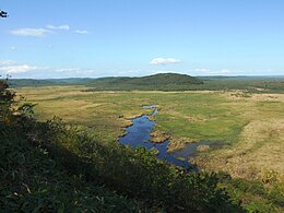 Overview of Kushiro Wetland
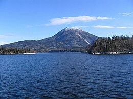
 View of Lake Mashū
 Sōunkyō, a gorge in the Daisetsu-zan Volcanic Area


- Twelve prefectural natural parks (道立自然公園). The prefectural natural parks cover 146,802 ha, the largest area of any prefecture.[7]
- Akkeshi Prefectural Natural Park
- Esan Prefectural Natural Park
- Furano-Ashibetsu Prefectural Natural Park
- Hiyama Prefectural Natural Park
- Kariba-Motta Prefectural Natural Park
- Matsumae-Yagoshi Prefectural Natural Park
- North Okhotsk Prefectural Natural Park
- Nopporo Shinrin Kōen Prefectural Natural Park
- Notsuke-Fūren Prefectural Natural Park
- Sharidake Prefectural Natural Park
- Shumarinai Prefectural Natural Park
- Teshiodake Prefectural Natural Park
| since | ||
|---|---|---|
| Kushiro Wetland | 釧路湿原 | 1980-06-17 |
| Lake Kutcharo | クッチャロ湖 | 1989-07-06 |
| Lake Utonai | ウトナイ湖 | 1991-12-12 |
| Kiritappu Wetland | 霧多布湿原 | 1993-06-10 |
| Lake Akkeshi, Bekkanbeushi Wetland | 厚岸湖・別寒辺牛湿原 | 1993-06-10, enlarged 2005-11-08 |
| Miyajima Marsh | 宮島沼 | 2002-11-18 |
| Uryūnuma Wetland | 雨竜沼湿原 | 2005-11-08 |
| Sarobetsu plain | サロベツ原野 | |
| Lake Tōfutsu | 濤沸湖 | |
| Lake Akan | 阿寒湖 | |
| Notsuke Peninsula, Notsuke Bay | 野付半島・野付湾 | |
| Lake Fūren, Shunkunitai | 風蓮湖・春国岱 |
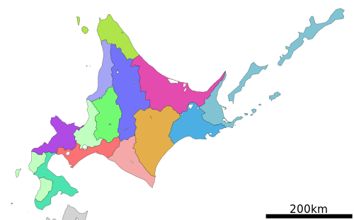
Subprefectures
As of April 2010[update], Hokkaidō has nine General Subprefectural Bureaus (総合振興局) and five Subprefectural Bureaus (振興局). Hokkaidō is one of eight prefectures in Japan that have subprefectures (支庁 shichō). However, it is the only one of the eight to have such offices covering the whole of its territory outside the main cities (rather than having them just for outlying islands or remote areas). This is mostly because of its great size; many parts of the prefecture are simply too far away to be effectively administered by Sapporo. Subprefectural offices in Hokkaidō carry out many of the duties that prefectural offices fulfill elsewhere in Japan.
1
a
2
3
b
4
c
5
d
6
7
8
9
e
(disputed)
(disputed)
| |||||||||
| Subprefecture | Japanese | Main city | Largest municipality | Pop. (2009[update]) |
Area (km2) |
Municipalities | |||
|---|---|---|---|---|---|---|---|---|---|
| 1 | Sorachi | 空知総合振興局 | Iwamizawa | Iwamizawa | 338,485 | 5,791.19 | 10 cities | 14 towns | |
| a | ↳ Ishikari | 石狩振興局 | Sapporo | Sapporo | 2,324,878 | 3,539.86 | 6 cities | 1 town | 1 village |
| 2 | Shiribeshi | 後志総合振興局 | Kutchan | Otaru | 234,984 | 4,305.83 | 1 city | 13 towns | 6 villages |
| 3 | Iburi | 胆振総合振興局 | Muroran | Tomakomai | 419,115 | 3,698.00 | 4 cities | 7 towns | |
| b | ↳ Hidaka | 日高振興局 | Urakawa | Shinhidaka | 76,084 | 4,811.97 | 7 towns | ||
| 4 | Oshima | 渡島総合振興局 | Hakodate | Hakodate | 433,475 | 3,936.46 | 2 cities | 9 towns | |
| c | ↳ Hiyama | 檜山振興局 | Esashi | Setana | 43,210 | 2,629.94 | 7 towns | ||
| 5 | Kamikawa | 上川総合振興局 | Asahikawa | Asahikawa | 527,575 | 10,619.20 | 4 cities | 17 towns | 2 villages |
| d | ↳ Rumoi | 留萌振興局 | Rumoi | Rumoi | 53,916 | 3,445.75 | 1 city | 6 towns | 1 village |
| 6 | Sōya | 宗谷総合振興局 | Wakkanai | Wakkanai | 71,423 | 4,625.09 | 1 city | 8 towns | 1 village |
| 7 | Okhotsk | オホーツク総合振興局 | Abashiri | Kitami | 309,487 | 10,690.62 | 3 cities | 14 towns | 1 village |
| 8 | Tokachi | 十勝総合振興局 | Obihiro | Obihiro | 353,291 | 10,831.24 | 1 city | 16 towns | 2 villages |
| 9 | Kushiro | 釧路総合振興局 | Kushiro | Kushiro | 252,571 | 5,997.38 | 1 city | 6 towns | 1 village |
| e | ↳ Nemuro | 根室振興局 | Nemuro | Nemuro | 84,035 | 3,406.23 | 1 city | 4 towns | * |
| * Japan claims the southern part of Kuril Islands (Northern Territories), currently administered by Russia, belong to Nemuro Subprefecture divided into six villages. However, the table above excludes these islands' data. | |||||||||
Climate

As Japan's coldest region, Hokkaidō has relatively cool summers and icy/snowy winters. Most of the island falls in the humid continental climate zone with Köppen climate classification Dfb (hemiboreal) in most areas but Dfa (hot summer humid continental) in some inland lowlands. The average August temperature ranges from 17 to 22 °C (62.6 to 71.6 °F), while the average January temperature ranges from −12 to −4 °C (10.4 to 24.8 °F), in both cases depending on elevation and distance from the ocean, though temperatures on the western side of the island tend to be a little warmer than on the eastern. The highest temperature ever recorded is 39.5 °C (103.1 °F) on 26 May 2019.[8]
The northern portion of Hokkaidō falls into the taiga biome[9] with significant snowfall. Snowfall varies widely from as much as 11 metres (400 in) on the mountains adjacent to the Sea of Japan down to around 1.8 metres (71 in) on the Pacific coast. The island tends to have isolated snowstorms that develop long-lasting snowbanks. Total precipitation varies from 1,600 millimetres (63 in) on the mountains of the Sea of Japan coast to around 800 millimetres (31 in) (the lowest in Japan) on the Sea of Okhotsk coast and interior lowlands and up to around 1,100 millimetres (43 in) on the Pacific side. The generally high quality of powder snow and numerous mountains in Hokkaidō make it a popular region for snow sports. The snowfall usually commences in earnest in November and ski resorts (such as those at Niseko, Furano, Teine and Rusutsu) usually operate between December and April. Hokkaidō celebrates its winter weather at the Sapporo Snow Festival.
During the winter, passage through the Sea of Okhotsk is often complicated by large floes of drift ice. Combined with high winds that occur during winter, this frequently brings air travel and maritime activity to a halt beyond the northern coast of Hokkaidō. Ports on the open Pacific Ocean and Sea of Japan are generally ice-free year round, though most rivers freeze during the winter.
Unlike the other major islands of Japan, Hokkaidō is normally not affected by the June–July rainy season and the relative lack of humidity and typically warm, rather than hot, summer weather makes its climate an attraction for tourists from other parts of Japan.
Climate data
| City | Jan | Feb | Mar | Apr | May | Jun | Jul | Aug | Sep | Oct | Nov | Dec |
|---|---|---|---|---|---|---|---|---|---|---|---|---|
| Sapporo | −0.4 / −6.4 (31.3 / 20.5) |
0.4 / −6.2 (32.7 / 20.8) |
4.5 / −2.4 (40.1 / 27.7) |
11.7 / 3.4 (53.1 / 38.1) |
17.9 / 9.0 (64.2 / 48.2) |
21.8 / 13.4 (71.2 / 56.1) |
25.4 / 17.9 (77.7 / 64.2) |
26.4 / 19.1 (79.5 / 66.4) |
22.8 / 14.8 (73.0 / 58.6) |
16.4 / 8.0 (61.5 / 46.4) |
8.7 / 1.6 (47.7 / 34.9) |
2.0 / −4.0 (35.6 / 24.8) |
| Hakodate | 0.9 / −6.0 (33.6 / 21.2) |
1.8 / −5.7 (35.2 / 21.7) |
5.8 / −2.2 (42.4 / 28.0) |
12.0 / 2.8 (53.6 / 37.0) |
17.0 / 8.0 (62.6 / 46.4) |
20.4 / 12.6 (68.7 / 54.7) |
24.1 / 17.3 (75.4 / 63.1) |
25.9 / 18.9 (78.6 / 66.0) |
23.2 / 14.6 (73.8 / 58.3) |
17.1 / 7.8 (62.8 / 46.0) |
10.0 / 1.8 (50.0 / 35.2) |
3.2 / −3.6 (37.8 / 25.5) |
| Asahikawa | −3.3 / −11.7 (26.1 / 10.9) |
−1.7 / −11.8 (28.9 / 10.8) |
3.0 / −6.1 (37.4 / 21.0) |
11.2 / 0.2 (52.2 / 32.4) |
18.8 / 6.1 (65.8 / 43.0) |
22.8 / 12.0 (73.0 / 53.6) |
26.2 / 16.4 (79.2 / 61.5) |
26.6 / 16.9 (79.9 / 62.4) |
21.9 / 11.7 (71.4 / 53.1) |
14.9 / 4.4 (58.8 / 39.9) |
6.2 / −1.5 (43.2 / 29.3) |
−0.8 / −8.0 (30.6 / 17.6) |
| Kushiro | −0.2 / −9.8 (31.6 / 14.4) |
−0.1 / −9.4 (31.8 / 15.1) |
3.3 / −4.2 (37.9 / 24.4) |
8.0 / 0.7 (46.4 / 33.3) |
12.6 / 5.4 (54.7 / 41.7) |
15.8 / 9.5 (60.4 / 49.1) |
19.6 / 13.6 (67.3 / 56.5) |
21.5 / 15.7 (70.7 / 60.3) |
20.1 / 12.9 (68.2 / 55.2) |
15.1 / 6.1 (59.2 / 43.0) |
8.9 / −0.3 (48.0 / 31.5) |
2.5 / −7.0 (36.5 / 19.4) |
| Wakkanai | −2.4 / −6.4 (27.7 / 20.5) |
−2.0 / −6.7 (28.4 / 19.9) |
1.6 / −3.1 (34.9 / 26.4) |
7.4 / 1.8 (45.3 / 35.2) |
12.4 / 6.3 (54.3 / 43.3) |
16.1 / 10.4 (61.0 / 50.7) |
20.1 / 14.9 (68.2 / 58.8) |
22.3 / 17.2 (72.1 / 63.0) |
20.1 / 14.4 (68.2 / 57.9) |
14.1 / 8.4 (57.4 / 47.1) |
6.3 / 1.3 (43.3 / 34.3) |
0.0 / −4.2 (32.0 / 24.4) |
| Rikubetsu | −2.5 / −19.6 (27.5 / −3.3) |
−1.4 / −18.8 (29.5 / −1.8) |
3.2 / −10.6 (37.8 / 12.9) |
10.5 / −2.5 (50.9 / 27.5) |
17.1 / 3.4 (62.8 / 38.1) |
20.6 / 9.1 (69.1 / 48.4) |
23.7 / 14.0 (74.7 / 57.2) |
24.4 / 15.0 (75.9 / 59.0) |
20.8 / 9.8 (69.4 / 49.6) |
14.7 / 1.8 (58.5 / 35.2) |
7.1 / −5.3 (44.8 / 22.5) |
−0.2 / −14.9 (31.6 / 5.2) |
| Saroma | −2.6 / −15.6 (27.3 / 3.9) |
−2.2 / −16.3 (28.0 / 2.7) |
2.5 / −9.5 (36.5 / 14.9) |
10.2 / −1.8 (50.4 / 28.8) |
16.9 / 3.8 (62.4 / 38.8) |
20.2 / 8.9 (68.4 / 48.0) |
23.9 / 13.6 (75.0 / 56.5) |
24.9 / 14.8 (76.8 / 58.6) |
21.6 / 10.1 (70.9 / 50.2) |
15.3 / 2.9 (59.5 / 37.2) |
7.5 / −3.2 (45.5 / 26.2) |
0.1 / −11.7 (32.2 / 10.9) |
| Okushiri | 1.6 / −2.4 (34.9 / 27.7) |
1.9 / −2.2 (35.4 / 28.0) |
5.3 / 0.7 (41.5 / 33.3) |
10.0 / 5.0 (50.0 / 41.0) |
14.6 / 9.3 (58.3 / 48.7) |
19.0 / 13.6 (66.2 / 56.5) |
22.9 / 17.9 (73.2 / 64.2) |
25.4 / 20.1 (77.7 / 68.2) |
22.6 / 17.5 (72.7 / 63.5) |
16.6 / 11.8 (61.9 / 53.2) |
10.0 / 5.1 (50.0 / 41.2) |
3.9 / −0.5 (39.0 / 31.1) |
| Erimo | 0.2 / −4.0 (32.4 / 24.8) |
−0.2 / −4.3 (31.6 / 24.3) |
2.2 / −1.9 (36.0 / 28.6) |
6.1 / 1.3 (43.0 / 34.3) |
10.1 / 5.0 (50.2 / 41.0) |
13.6 / 9.0 (56.5 / 48.2) |
17.5 / 13.4 (63.5 / 56.1) |
19.9 / 15.8 (67.8 / 60.4) |
19.0 / 14.9 (66.2 / 58.8) |
14.7 / 10.2 (58.5 / 50.4) |
9.3 / 4.2 (48.7 / 39.6) |
3.3 / −1.3 (37.9 / 29.7) |
| Climate data for Sapporo (1991−2020 normals, extremes 1877−present) (Köppen Dfa) | |||||||||||||
|---|---|---|---|---|---|---|---|---|---|---|---|---|---|
| Month | Jan | Feb | Mar | Apr | May | Jun | Jul | Aug | Sep | Oct | Nov | Dec | Year |
| Record high °C (°F) | 11.2 (52.2) |
10.8 (51.4) |
18.3 (64.9) |
28.0 (82.4) |
34.2 (93.6) |
33.7 (92.7) |
36.0 (96.8) |
36.2 (97.2) |
32.7 (90.9) |
27.3 (81.1) |
22.4 (72.3) |
14.8 (58.6) |
36.2 (97.2) |
| Mean maximum °C (°F) | 5.1 (41.2) |
7.0 (44.6) |
12.3 (54.1) |
21.3 (70.3) |
27.4 (81.3) |
29.0 (84.2) |
31.4 (88.5) |
32.0 (89.6) |
28.8 (83.8) |
22.7 (72.9) |
17.2 (63.0) |
9.4 (48.9) |
32.7 (90.9) |
| Average high °C (°F) | −0.4 (31.3) |
0.4 (32.7) |
4.5 (40.1) |
11.7 (53.1) |
17.9 (64.2) |
21.8 (71.2) |
25.4 (77.7) |
26.4 (79.5) |
22.8 (73.0) |
16.4 (61.5) |
8.7 (47.7) |
2.0 (35.6) |
13.1 (55.6) |
| Daily mean °C (°F) | −3.2 (26.2) |
−2.7 (27.1) |
1.1 (34.0) |
7.3 (45.1) |
13.0 (55.4) |
17.0 (62.6) |
21.1 (70.0) |
22.3 (72.1) |
18.6 (65.5) |
12.1 (53.8) |
5.2 (41.4) |
−0.9 (30.4) |
9.2 (48.6) |
| Average low °C (°F) | −6.4 (20.5) |
−6.2 (20.8) |
−2.4 (27.7) |
3.4 (38.1) |
9.0 (48.2) |
13.4 (56.1) |
17.9 (64.2) |
19.1 (66.4) |
14.8 (58.6) |
8.0 (46.4) |
1.6 (34.9) |
−4.0 (24.8) |
5.7 (42.3) |
| Mean minimum °C (°F) | −11.8 (10.8) |
−11.7 (10.9) |
−7.9 (17.8) |
−1.4 (29.5) |
3.9 (39.0) |
9.0 (48.2) |
13.7 (56.7) |
14.7 (58.5) |
8.7 (47.7) |
2.1 (35.8) |
−4.6 (23.7) |
−9.0 (15.8) |
−12.8 (9.0) |
| Record low °C (°F) | −27.0 (−16.6) |
−28.5 (−19.3) |
−22.6 (−8.7) |
−14.6 (5.7) |
−4.2 (24.4) |
0.0 (32.0) |
5.2 (41.4) |
5.3 (41.5) |
−0.9 (30.4) |
−4.4 (24.1) |
−15.5 (4.1) |
−24.7 (−12.5) |
−28.5 (−19.3) |
| Average precipitation mm (inches) | 108.4 (4.27) |
91.9 (3.62) |
77.6 (3.06) |
54.6 (2.15) |
55.5 (2.19) |
60.4 (2.38) |
90.7 (3.57) |
126.8 (4.99) |
142.2 (5.60) |
109.9 (4.33) |
113.8 (4.48) |
114.5 (4.51) |
1,146.1 (45.12) |
| Average snowfall cm (inches) | 137 (54) |
116 (46) |
74 (29) |
6 (2.4) |
0 (0) |
0 (0) |
0 (0) |
0 (0) |
0 (0) |
1 (0.4) |
30 (12) |
113 (44) |
479 (189) |
| Average precipitation days (≥ 0.5 mm) | 22.1 | 19.2 | 18.3 | 12.3 | 10.2 | 9.3 | 9.4 | 10.5 | 11.7 | 14.0 | 18.3 | 19.9 | 175.1 |
| Average relative humidity (%) | 69 | 68 | 65 | 61 | 65 | 72 | 75 | 75 | 71 | 67 | 67 | 68 | 69 |
| Average dew point °C (°F) | −8 (18) |
−8 (18) |
−5 (23) |
−1 (30) |
6 (43) |
12 (54) |
16 (61) |
18 (64) |
13 (55) |
6 (43) |
0 (32) |
−6 (21) |
4 (39) |
| Mean monthly sunshine hours | 90.4 | 103.5 | 144.7 | 175.8 | 200.4 | 180.0 | 168.0 | 168.1 | 159.3 | 145.9 | 99.1 | 82.7 | 1,718 |
| Average ultraviolet index | 1 | 1 | 1 | 3 | 4 | 5 | 5 | 5 | 4 | 2 | 1 | 1 | 3 |
| Source 1: Japan Meteorological Agency[10][11] | |||||||||||||
| Source 2: Weather Atlas (UV),[12] Time and Date (dewpoints, 2005-2015),[13] Météo Climat[14][15] | |||||||||||||
Gallery
 Geofeatures map of Hokkaido
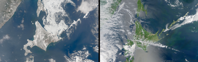
 Hokkaido seen from the International Space Station
 Lake Shiretoko Goko in the town of Shari, Okhotsk Subprefecture, Hokkaidō
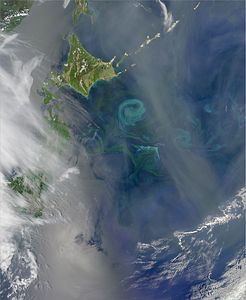 The Oyashio Current colliding with the Kuroshio Current off the coast of Hokkaido. When two currents collide, they create eddies. Phytoplankton growing in the surface waters become concentrated along the boundaries of these eddies, tracing out the motions of the water.


See also
- Geography of Japan
- Kuril Islands
- Sakhalin
- Japan Trench
References
- Nussbaum, Louis-Frédéric. (2005). "Hokkaidō" in Japan Encyclopedia, p. 343, p. 343, at Google Books
- Hirata, Daisuke; et al. (2013). "Molecular Phylogeography of the Brown Bear (Ursus arctos) in Northeastern Asia Based on Analyses of Complete Mitochondrial DNA Sequences". Mol Biol Evol. 30 (7): 1644–1652. doi:10.1093/molbev/mst077. PMID 23619144.
- Zhang, D.; Katsuki, T.; Rushforth, K. (2013). "Abies sachalinensis". IUCN Red List of Threatened Species. 2013: e.T42298A2970610. doi:10.2305/IUCN.UK.2013-1.RLTS.T42298A2970610.en. Retrieved 7 September 2021.
- Japanese Wiki page ja:北海道
- "M 6.6 - 27km E of Tomakomai, Japan". United States Geological Survey. Archived from the original on 6 September 2018. Retrieved 6 September 2018.
- "Earthquake ALERT! 6.1-magnitude quake strikes this country". Zee Business. 2021-05-16. Archived from the original on 2021-05-16. Retrieved 2021-05-16.
- "General overview of area figures for Natural Parks by prefecture" (PDF). Ministry of the Environment Japan. 31 March 2008. Archived (PDF) from the original on 2012-04-21. Retrieved 2009-06-02.
- Sim, Walter (26 May 2019). "Hokkaidō sizzling in temperatures up to 39.5 deg C as unseasonal heat wave grips Japan". The Straits Times. Archived from the original on 27 May 2019. Retrieved 27 May 2019.
- C.Michael Hogan. 2011. Taiga. eds. M.McGinley & C.Cleveland. Encyclopedia of Earth. National Council for Science and the Environment. Washington DC Archived 2013-11-04 at the Wayback Machine
- 気象庁 / 平年値(年・月ごとの値). Japan Meteorological Agency. Retrieved May 19, 2021.
- 観測史上1~10位の値(年間を通じての値). Japan Meteorological Agency. Retrieved 1 March 2022.
- "Sapporo, Japan – Detailed climate information and monthly weather forecast". Weather Atlas. Retrieved 6 August 2022.
- "Climate & Weather Averages in Sapporo". Time and Date. Retrieved 6 August 2022.
- "Météo climat stats for Sapporo". Météo Climat. Retrieved 1 March 2022.
- "Météo climat stats for Sapporo". Météo Climat. Retrieved 1 March 2022.
Другой контент может иметь иную лицензию. Перед использованием материалов сайта WikiSort.org внимательно изучите правила лицензирования конкретных элементов наполнения сайта.
WikiSort.org - проект по пересортировке и дополнению контента Википедии