geo.wikisort.org - Island
Rebun Island (礼文島, Rebun-tō, Ainu: Repun) is an island in the Sea of Japan off the northwestern tip of Hokkaidō, Japan. The island sits 50 kilometres (31 mi) off the coast of Hokkaidō. Rebun stretches 29 kilometres (18 mi) from north to south and 8 kilometres (5.0 mi) from east to west. The island covers approximately 80 square kilometres (31 sq mi). Rebun Island is located 10 kilometres (6.2 mi) northwest of Rishiri Island, and the two islands are separated by the Rebun Channel.[1][2][3]
Native name: 礼文島, Rebun-tō | |
|---|---|
 | |
 Rebun | |
| Geography | |
| Location | East Asia |
| Coordinates | 45°22′07″N 141°00′55″E |
| Archipelago | Japanese Archipelago |
| Area | 80 km2 (31 sq mi) |
| Length | 29 km (18 mi) |
| Width | 8 km (5 mi) |
| Coastline | 72 km (44.7 mi) |
| Highest elevation | 490.0 m (1607.6 ft) |
| Highest point | Mount Rebun |
| Administration | |
| Prefecture | Hokkaido |
| Subprefecture | Sōya Subprefecture |
| District | Rebun District |
| Town | Rebun |
| Demographics | |
| Population | 3,194 (2007-12-31) |
| Pop. density | 39.3/km2 (101.8/sq mi) |
| Ethnic groups | Ainu, Japanese |

Rebun Island is known for its alpine flowers and the 8-Hour Hiking Course which runs from one end of the island to the other, north to south. The hiking course can be broken into two sections, known as the 4-Hour Hiking Courses. Rebun Island is home to a chashi, or hilltop fortification of the Ainu people. The highest point on the island is Mount Rebun (490 metres (1,610 ft)).[2] The island is part of the Rishiri-Rebun-Sarobetsu National Park.
Fossilized remains of long-finned pilot whales that are now extinct in the north Pacific have been excavated on Rebun Island, [4] and remains of funerals for orcas, possibly referring them as Repun Kamuy (God of Sea/Offshore) have been found as well.[5] Rebun Island is also the site where the last reliable record of the extinct Japanese sea lion came from in 1974.
Etymology
The name of the island comes from the Ainu language, in which "Repun" means "(island) in the open sea" (from rep "the offing, open sea" + -un "to be in ~").[1][2]
Climate
| Climate data for Rebun, 2003–2020 normals, extremes 2004–present | |||||||||||||
|---|---|---|---|---|---|---|---|---|---|---|---|---|---|
| Month | Jan | Feb | Mar | Apr | May | Jun | Jul | Aug | Sep | Oct | Nov | Dec | Year |
| Record high °C (°F) | 6.9 (44.4) |
6.7 (44.1) |
11.0 (51.8) |
17.4 (63.3) |
20.8 (69.4) |
24.6 (76.3) |
29.9 (85.8) |
30.5 (86.9) |
29.0 (84.2) |
22.3 (72.1) |
15.5 (59.9) |
10.9 (51.6) |
30.5 (86.9) |
| Average high °C (°F) | −2.7 (27.1) |
−2.1 (28.2) |
1.7 (35.1) |
6.6 (43.9) |
11.6 (52.9) |
15.9 (60.6) |
20.4 (68.7) |
22.6 (72.7) |
20.5 (68.9) |
13.9 (57.0) |
6.1 (43.0) |
−0.3 (31.5) |
9.5 (49.1) |
| Daily mean °C (°F) | −4.6 (23.7) |
−4.3 (24.3) |
−0.4 (31.3) |
4.1 (39.4) |
8.5 (47.3) |
12.8 (55.0) |
17.3 (63.1) |
19.7 (67.5) |
17.4 (63.3) |
11.2 (52.2) |
3.6 (38.5) |
−2.4 (27.7) |
6.9 (44.4) |
| Average low °C (°F) | −6.5 (20.3) |
−6.4 (20.5) |
−2.4 (27.7) |
1.8 (35.2) |
6.0 (42.8) |
10.3 (50.5) |
14.9 (58.8) |
17.3 (63.1) |
14.5 (58.1) |
8.4 (47.1) |
1.2 (34.2) |
−4.5 (23.9) |
4.6 (40.2) |
| Record low °C (°F) | −15.8 (3.6) |
−17.1 (1.2) |
−9.6 (14.7) |
−5.7 (21.7) |
0.2 (32.4) |
4.0 (39.2) |
8.1 (46.6) |
10.9 (51.6) |
5.8 (42.4) |
−1.1 (30.0) |
−11.4 (11.5) |
−13.4 (7.9) |
−17.1 (1.2) |
| Average precipitation mm (inches) | 73.4 (2.89) |
51.6 (2.03) |
44.1 (1.74) |
49.2 (1.94) |
79.7 (3.14) |
84.6 (3.33) |
101.0 (3.98) |
138.6 (5.46) |
131.1 (5.16) |
100.4 (3.95) |
98.4 (3.87) |
91.5 (3.60) |
1,043.6 (41.09) |
| Average precipitation days (≥ 1.0 mm) | 17.9 | 14.4 | 10.9 | 8.7 | 9.7 | 9.6 | 7.5 | 8.9 | 10.5 | 11.6 | 12.9 | 16.2 | 138.8 |
| Mean monthly sunshine hours | 47.5 | 72.2 | 153.8 | 192.7 | 170.4 | 125.9 | 126.5 | 154.2 | 186.7 | 159.6 | 82.0 | 42.5 | 1,514.3 |
| Source 1: JMA[6] | |||||||||||||
| Source 2: JMA[7] | |||||||||||||
Areas of interest
- Mount Rebun
- Peach Rock, or Momoiwa
- Jizo Rock
- Cat Rock, or Nekoiwa
- Cape Sukoton
- Cape Kaneda
- Cape Gorota
- Cape Sukai
- Todo Island
- Lake Kushu
- Yamunai Valley
- Rebun Forest Road
- Rebun Falls
Communities
All communities on Rebun Island are part of the town of Rebun in Rebun District. From roughly from north to south, they are:[8]
- Sukoton
- Awabikoton
- Hamanaka
- Funadomari
- Horodomari
- Uedomari
- Nairo
- Kitousu
- Kafukai
- Kafuka
- Shiretoko
Transportation
- Ferry link to Rishiri Island, Wakkanai, and Otaru via Rishiri
- Air link to Wakkanai Airport
Ancient people
A Jomon woman excavated from Funadomari remains (about 3,800 - 3,500 YBP) on the Rebun Island in Hokkaido belongs to Haplogroup D1b2a(D-CTS220).[9] This discovery proved the hypothesis that Haplogroup D1b is one of the Jomon linages.
In popular culture
In the manga and anime series Food Wars!: Shokugeki no Soma, the island is the last step in the Promotion test which takes place across Hokkaido Island.
Gallery
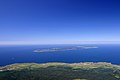 Rebun island (background) seen from Mount Rishiri
 Lake Kusyu on Rebun island
 Neko-iwa, 'cat rock'
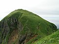 Momo-iwa, 'peach rock'
 Sukai Cape
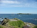 Sukoton Cape and Todo island
 Rebun Island in 2014


References
- "礼文島" [Rebun Island]. Dijitaru Daijisen (in Japanese). Tokyo: Shogakukan. 2012. OCLC 56431036. Archived from the original on 2007-08-25. Retrieved 2012-08-27.
- "礼文島" [Rebun Island]. Nihon Kokugo Daijiten (in Japanese). Tokyo: Shogakukan. 2012. OCLC 56431036. Archived from the original on 2007-08-25. Retrieved 2012-08-27.
- "礼文島" [Rebun Island]. Nihon Daihyakka Zensho (Nipponika) (in Japanese). Tokyo: Shogakukan. 2012. OCLC 153301537. Archived from the original on 2007-08-25. Retrieved 2012-08-22.
- Amano M. (2012). "みちのくの海のイルカたち(特集 みちのくの海と水族館の海棲哺乳類)" (PDF). Isana 56. Faculty of Fisheries of University of Nagasaki, Isanakai: 60–65. Retrieved 2017-03-09.
- Miyanaga T.. 2014. "(北海道)「シャチ送り」の遺構か 礼文島の遺跡で出土". Asahi Shimbun. Retrieved on October 04, 2017
- 観測史上1~10位の値(年間を通じての値). JMA. Retrieved February 16, 2022.
- 気象庁 / 平年値(年・月ごとの値). JMA. Retrieved February 16, 2022.
- Bisignani, J. D. (December 1993). "Dohoku-Northern Hokkaido". In Taran March (ed.). Japan Handbook (Second ed.). Chico, CA USA: Moon Publications, Inc. pp. 836–841. ISBN 0-918373-70-0.
- 神澤ほか(2016)「礼文島船泊縄文人の核ゲノム解析」第70回日本人類学大会 (in Japanese)
External links
 Rebun Island travel guide from Wikivoyage
На других языках
[de] Rebun (Insel)
Rebun (jap. .mw-parser-output .Hani{font-size:110%}礼文島, Rebun-tō) ist eine kleine japanische Insel im Japanischen Meer vor der Nordwestspitze von Hokkaidō.- [en] Rebun Island
[es] Isla Rebun
La isla Rebun (en japonés, 礼文島, Rebun-tō; en ainu, Repun) es una pequeña isla costera de Japón.que se encuentra en aguas del mar de Japón frente a la costa noroeste de la gran isla de Hokkaido. Administrativamente pertenece a la prefectura de Hokkaido y es parte del parque nacional de Rishiri-Rebun-Sarobetsu. La ciudad más grande de Rebun es Kafukakou, dentro de la isla se encuentra el lago Kusyu.[fr] Rebun-tō
L'île Rebun ou Rebun-tō (礼文島, Rebun-tō?) est une île située en mer du Japon, au nord-ouest de Hokkaidō. L'île est à environ 50 km des côtes de Hokkaidō.[it] Rebun
Rebun è un'isola del Giappone, sita circa 50 km al largo dell'estremità nord occidentale dell'isola di Hokkaidō, e circa 10 km a nord dell'isola Rishiri; con questa fa parte del parco nazionale di Rishiri-Rebun-Sarobetsu.[ru] Ребун (остров)
Ребун (яп. 礼文島) — вулканический остров в Японском море примерно в 45 км от северо-западного побережья Хоккайдо к западу от города Вакканай. От соседнего острова Рисири отделен проливом Ребун. Принадлежит Японии, префектура Хоккайдо, округ Соя, уезд Ребун. Площадь острова — 81,33 км², в длину — 29 км, в ширину до 8 км.Другой контент может иметь иную лицензию. Перед использованием материалов сайта WikiSort.org внимательно изучите правила лицензирования конкретных элементов наполнения сайта.
WikiSort.org - проект по пересортировке и дополнению контента Википедии