geo.wikisort.org - Mountains
Mount Tarumae (樽前山, Tarumae-zan) is located in the Shikotsu-Toya National Park in Hokkaidō, Japan. It is located near both Tomakomai and Chitose towns and can be seen clearly from both. It is on the shores of Lake Shikotsu, a caldera lake. Tarumae is a 1,041 metre active andesitic stratovolcano, with a lava dome.
| Mount Tarumae | |
|---|---|
| 樽前山 | |
 Seen from the SSE | |
| Highest point | |
| Elevation | 1,041 m (3,415 ft)[1] |
| Listing | List of mountains and hills of Japan by height List of volcanoes in Japan |
| Coordinates | 42°41′24″N 141°22′41″E[2] |
| Geography | |
 Mount Tarumae Hokkaidō, Japan  Mount Tarumae Mount Tarumae (Hokkaido) | |
| Parent range | Nasu Volcanic Zone |
| Topo map | Geographical Survey Institute (国土地理院, Kokudochiriin) 50000:1 樽前山, 25000:1 樽前山, 25000:1 風不死岳 |
| Geology | |
| Mountain type | Caldera |
| Volcanic arc/belt | Northeastern Japan Arc |
| Last eruption | 1982[3] |
| Climbing | |
| Easiest route | Hike |

Eruptions

The most recent eruption, in 1982, was a phreatic eruption.[4] Previous major eruptions have occurred in 1667, 1739 (plinian eruption of VEI 5[5]), and 1909. The 1667 and 1739 eruptions were responsible for its present shape. Other eruptions were in 1919–21, 1923, 1926, 1933, 1936, 1944, 1951, 1953–55, and 1978.[6]
Tarumae is an 'A' rank volcano — most likely to erupt in the relatively near future.[4]
Hokkaido Natural Monument
Designated as a Hokkaido Natural Monument, it is popular as an easy climb for hikers who may start at the seventh station and then take an hour to reach the crater.
At the foot of Tarumae on the north-west side one can find an impressive moss-covered cavern (Koke-no-domon).
Gallery
 Relief Map
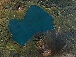 With Lake Shikotsu. Mount Tarumae in the bottom.
 Mt. Tarumae and Mt. Fuppuishi as seen from the NNE.
 Lava Dome


See also
- List of volcanoes in Japan
- List of mountains in Japan
- Tarumaezan Shrine
References
- Geographical Survey Institute
- Mt. Tarumae
- Tarumae Volcano - Geological Survey of Japan
- "Volcano Field Trip". Archived from the original on 2011-07-22. Retrieved 2007-10-02.
- "Enlightenment activities for improvement on disasters from Tarumae Volcano, Japan". Cities on Volcanoes. January 2006. pp. 4, 23–27. Archived from the original (doc) on 2012-04-27.
- "GEOPHYSICAL OBSERVATIONS IN TARUMAI VOLCANO, HOKKAIDO, JAPAN" (doc). Makoto Tamura Geological Survey of Hokkaido.
External links
- Tarumaesan - Japan Meteorological Agency (in Japanese)
- "Tarumaesan: National catalogue of the active volcanoes in Japan" (PDF). - Japan Meteorological Agency
- Tarumae Volcano - Geological Survey of Japan
- "Shikotsu". Global Volcanism Program. Smithsonian Institution. Retrieved 2021-06-25.
На других языках
- [en] Mount Tarumae
[es] Monte Tarumae
Monte Tarumae (Tarumae-zan) es un triple volcán situado en el Parque nacional Shikotsu-Tōya, en Hokkaidō, Japón. Se encuentra próximo a las ciudades de Tomakomai y Chitose pudiéndose ver claramente desde ambas ciudades, a su ver el monte se encuentra a orillas del lago Shikotsu, un lago formado en una cáldera volcánica. El Monte Tarumae se eleva a 1.041 metros y es un volcán activo, con una cúpula de lava.[fr] Mont Tarumae
Le mont Tarumae (樽前山, Tarumae-zan?) est un stratovolcan andésitique actif avec dôme de lave situé dans le parc national de Shikotsu-Tōya en Hokkaidō au Japon. Culminant à 1 041 m d'altitude sur les rives du lac Shikotsu, un lac de caldeira, il se trouve sur le territoire des villes de Tomakomai et Chitose.[ru] Тарумаэ
Тарума́э[2] (яп. 樽前山) — вулкан на японском острове Хоккайдо, на берегу озера Сикоцу, неподалеку от города Томакомай.Другой контент может иметь иную лицензию. Перед использованием материалов сайта WikiSort.org внимательно изучите правила лицензирования конкретных элементов наполнения сайта.
WikiSort.org - проект по пересортировке и дополнению контента Википедии