geo.wikisort.org - Island
Ferdinandea Island (also Graham Island, Graham Bank or Graham Shoal; French: Ile Julia) is a certain volcanic island/seamount in the Mediterranean Sea near the island of Sicily that has, on more than one occasion, risen above the Mediterranean via volcanic action and soon thereafter been washed away. Since 300 BC this cycle of events has occurred four times.[3]
| Ferdinandea Island Graham Island (English) Ile Julia (French) | |
|---|---|
 Approximate location of Ferdinandea Island | |
| Summit depth | Roughly 8 m (26 ft)[1] |
| Height | 63 m (207 ft) (maximum)[2] |
| Summit area | Campi Flegrei del Mar di Sicilia (Phlegraean Fields of the Sea of Sicily)[citation needed] |
| Location | |
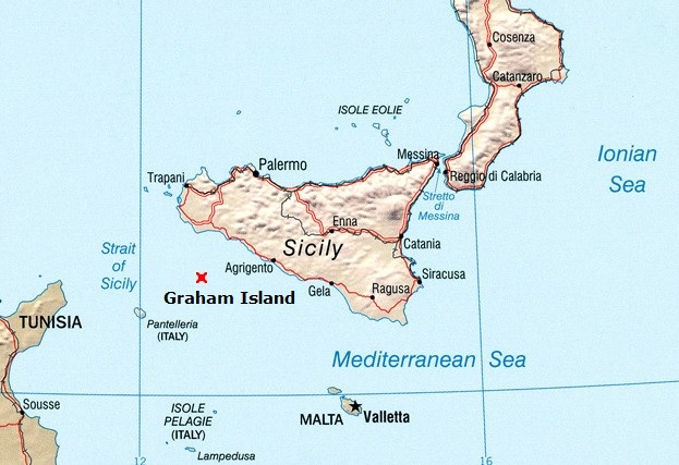
| Location | Between Sicily and Tunisia |
| Coordinates | 37°10′N 12°43′E |
| Geology | |
| Type | Submarine volcano |
| Last eruption | 1863 |
The top of the island is presently 6 metres below sea level. The island's most recent "appearance" occurred in July 1831, but then by January 1832 the portion of the island above sea level had been entirely washed away again by the wind and the waves of the Mediterranean Sea. The 1831 version of the island was first visited by the Sicilian customs official Michele Fiorini on 17 July 1831, who planted an oar there to claim the newly emerged island for the Kingdom of Sicily.[4]
On 2 August 1831 Humphrey Fleming Senhouse, the captain of the first rate Royal Navy ship of the line St Vincent named the island after Sir James Graham, the First Lord of the Admiralty, and claimed the island for the United Kingdom. In 1831, during the brief six-month lifespan of the island, a four-way dispute over the island's sovereignty arose, which was still unresolved when the island again disappeared beneath the waves in early 1832.
The island is a part of the underwater volcano Empedocles, 30 km (19 mi) south of Sicily, which is one of a number of submarine volcanoes known as the Campi Flegrei del Mar di Sicilia. Seamount eruptions have raised it above sea level several times before erosion submerged it again.
During its brief life in 1831, French geologist Constant Prévost was on hand, accompanied by an artist, to witness it in July 1831; he named it Île Julia, for its July appearance, and reported in the Bulletin de la Société Géologique de France.[5][6] Some observers at the time wondered if a chain of mountains would spring up, linking Sicily to Tunisia and thus upsetting the geopolitics of the region.[citation needed] It showed signs of volcanic activity in 2000 and 2002, forecasting a possible appearance; however, as of 2016[update] it remains 6 m (20 ft) under sea level.
Early history
Volcanic activity at Ferdinandea Island was first recorded during the First Punic War during the 3rd century BC. The island is believed to have appeared and disappeared four or five times since then.[7] Several eruptions have been reported since the 17th century AD.[8] The island is located in a volcanic area known as the Campi Flegrei del Mar di Sicilia (Phlegraean Fields of the Sea of Sicily), in between Sicily and Tunisia in the Mediterranean Sea. Many submarine volcanoes (seamounts) exist in the region, as well as some volcanic islands such as Pantelleria.
1831 eruption and competing claims of sovereignty
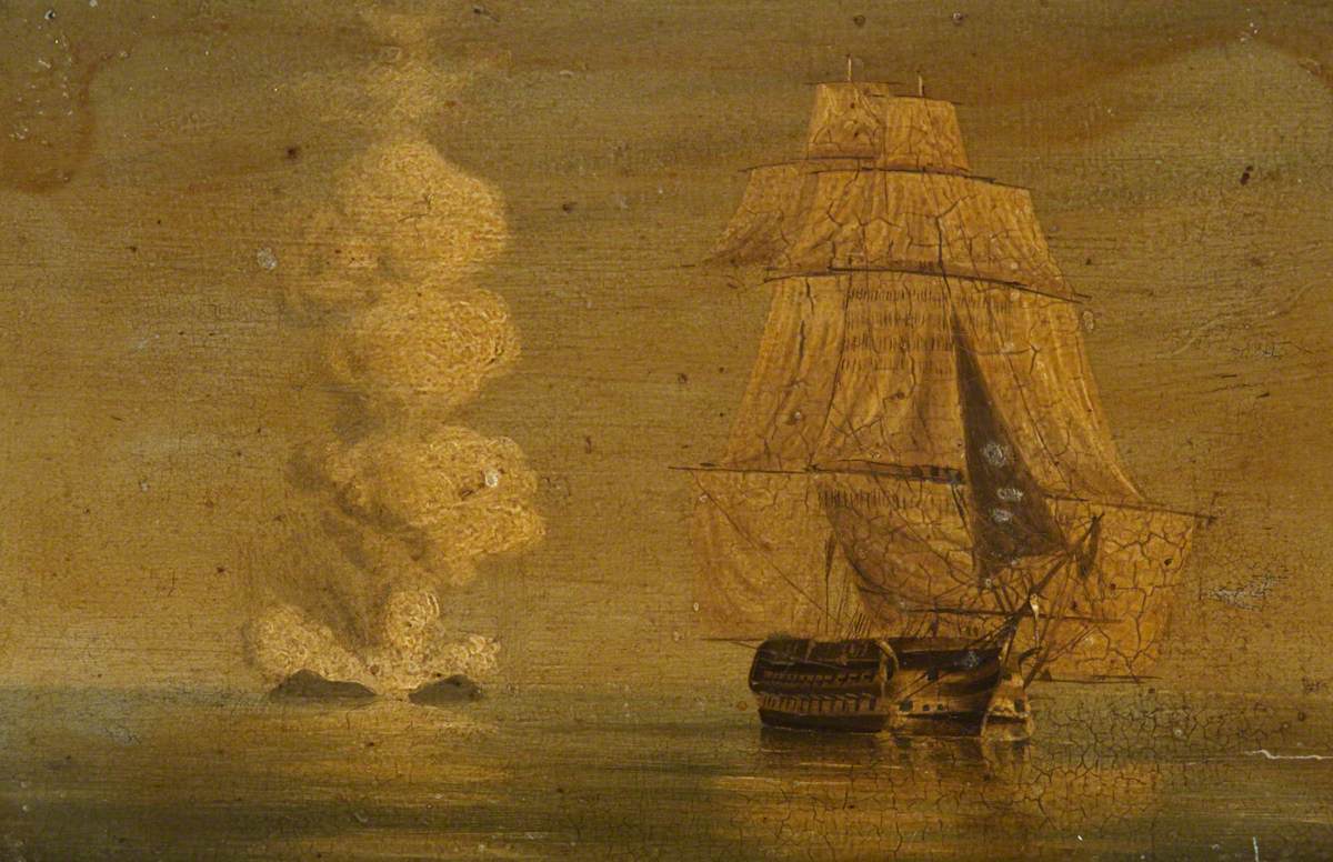
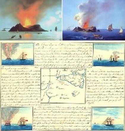
Ferdinandea Island's most recent appearance as an island was in July 1831. The first reports of high seismic activity and/or eruptions occurred during a period spanning from 28 June to 10 July 1831. These reports came from the nearby town of Sciacca.[2] On 4 July an odour of sulfur spread through the town reportedly in such quantities that it blackened silver.[2] On 13 July, a column of smoke was clearly seen from St. Domenico. The residents believed it to be a ferry on fire.[2] On the same day, the brig Gustavo passed through the area, confirming a bubbling in the sea that the captain thought was a sea monster. Another ship reported dead fish floating in the water.
By 17 July, a fully grown islet had formed enough to where Sicilian customs official Michele Fiorini was able to land there and to claim the island for the Kingdom of Sicily.[2][4]
On 2 August 1831, Humphrey Fleming Senhouse, the captain of the first rate Royal Navy ship of the line HMS St Vincent claimed the Island for the British Crown and named it after Sir James Graham, the First Lord of the Admiralty. The eruptions of 1831 resulted in the island increasing in size to about four sq km (1+1⁄2 sq mi). However, it was composed of loose tephra, easily eroded by wave action, and when the eruptive episode ended it rapidly subsided, disappearing beneath the waves in January 1832, before the issue of its sovereignty could be resolved. Fresh eruptions in 1863 caused the island to reappear briefly before again sinking below sea level. At its maximum (in July and August 1831), it was 4,800 m (15,700 ft) in circumference and 63 m (207 ft) in height.[2] It sported two small lakes, the larger of which was 20 metres (66 ft) in circumference and 2 m (6 ft 7 in) in depth.[2]
Dispute

In the months ahead, Ferdinandea Island eventually became the subject of a four-way dispute over its sovereignty, the island had been claimed for the United Kingdom and given the name Graham Island. The King of the Two Sicilies, Ferdinand II, after whom Sicilians named the island Ferdinandea, also sent ships to the nascent island to claim it for the Bourbon crown. The French Navy made a landing, and called the island Julia. Spain also declared its territorial ambitions.[9] Each wanted the island for its useful position in the Mediterranean trade route (to England and France) and its close position to Spain and Italy.[citation needed]
Initial diplomatic disputes
In August 1831, the volcano had risen to above sea level. Although still only a couple of rocks, the Royal Navy thought it was very suitable as a base to control the traffic in the Mediterranean, as it was closer to the European continent than the island of Malta, a Crown Colony.[2] The British fleet landed, named it Graham Island, after Sir James Graham, the First Lord of the Admiralty, and planted their flag, the Union Jack.[1]
The King of Sicily also realized its strategic significance, and dispatched the corvette Etna to claim the new land and dub it Ferdinandea in honour of King Ferdinand II. Last on the scene was Constant Prévost, a co-founder of the French Geological Society, who compared the eruption to a bottle of champagne being uncorked. He named the island Julia, because it was born in July, and probably also in reference to France's July Monarchy. Diplomatic disputes over the island's status ensued.[1] For five months, conflicting claims of sovereignty raged in newspapers and elsewhere as the four different nations vied for control over a roughly 60-metre-high (200 ft) piece of basalt.[10]
Hopes for development
During the island's brief lifespan tourists began to travel to the island to see its two small lakes. Sailors watched it when passing by, and nobles of the House of Bourbon reportedly planned to set up a holiday resort on its beaches. None of these ideas came to fruition, however, as the island soon sank back beneath the waters. By 17 December 1831, officials reported no trace of it. As dynamically as the seamount appeared, it disappeared, defusing the conflict with it.[11]
Recent seismic activity
After 1863, the volcano lay dormant for many decades, its summit just 8 m (26 ft) below sea level. In 2000, renewed seismic activity around Ferdinandea Island led volcanologists to speculate that a new eruptive episode could be imminent, and the seamount might once again become an island.[12] In November 2002 the Institute of Geophysics and Volcanology in Rome observed minor seismic activity and gas emissions.[11] They put the time of resurfacing at a couple of weeks or months. Italian sailors put an Italian flag on the top of the bank to avoid other nations' claims if the former island resurfaced. Despite showing signs in both 2000 and 2002, the seismicity did not lead to volcanic eruptions and as of 2006[update] Ferdinandea's summit remains about 8 metres (26 ft) below sea level.[1]
Year 2000 Sicilian plaque with claim of Italian sovereignty
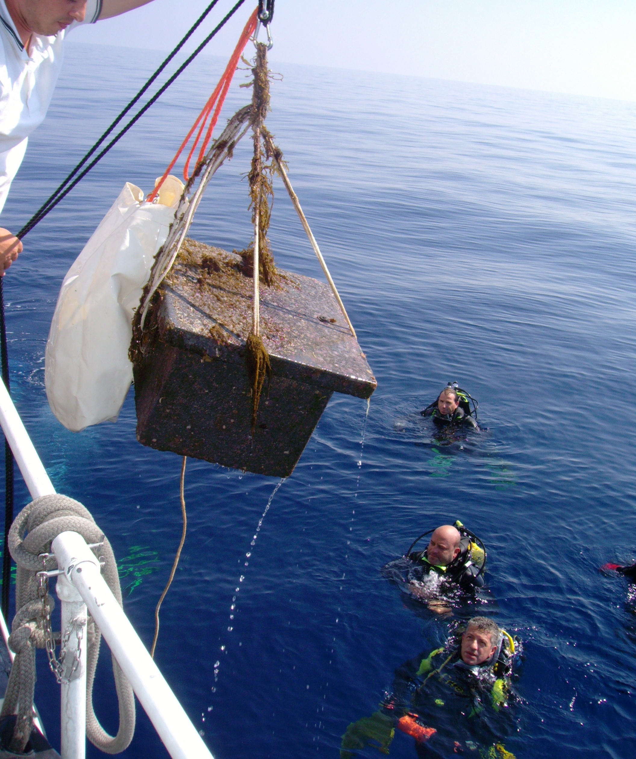
To forestall a renewal of the sovereignty disputes, Italian divers planted a flag on the top of the volcano in advance of its expected resurfacing.[11] To bolster their case, Sicilians, who call it Ferdinandea, summoned the descendant of the Bourbon King of Naples. In a ceremony filmed by a flotilla of camera crews, Prince Carlo di Bourbon lowered a plaque into the waves and told cheering locals: "It will always be Sicilian." Lobbied by fishermen and sailors, Ignazio Cucchiara, the mayor of Sciacca, invited Prince Carlo to attend the ceremony with his wife, The Duchess of Castro Camilla Crociani. To accommodate television crews the plaque was lowered well before reaching the shoal, which is a danger to shipping. Choppy waters forced divers to postpone the operation a week, until 13 November 2000.[12] The diving crew planted Sicily's flag, which features a Medusa's head surrounded by three naked legs – a sign traditionally interpreted as "keep away."
The marble plaque, weighing 150 kg (330 lb), was inscribed "This piece of land, once Ferdinandea, belonged and shall always belong to the Sicilian people."[citation needed] The Prince told cheering locals: "It will always be Sicilian." But within six months, it had been fractured into twelve pieces, mostly likely by fishing gear but possibly by vandalism.[6]
Significance
Scientific study


The sudden geologic phenomenon was observed and studied by numerous scientists. Among the Germans were Hoffmann, Schultz, and Philippi. Among the English were Edward Davy and Warington Wilkinson Smyth. Among the French was Constant Prévost. Among the Italians there was Scinà Domenico (1765-1837) who published his observations in the "Effeméridi Sicilians" (1832, vol. 2), and Carlo Gemmellaro (1787–1866), teacher of geology and mineralogy at Catania University, who published "Actions of the Gioenia Academy of Catania" (1831, vol.8).[2]
In 2006, further study revealed Ferdinandea Island to be just one part of the larger volcanic cone Empedocles.[7]
Marine significance
The island/ reef is still referenced on marine charts, as its top is only 6 metres (20 feet) short of breaking the surface, it thus becomes a potentially dangerous hidden obstacle for many seafaring vessels whose keels most often run deeper than this.[10] It is also a small shoal on which near-surface maritime creatures dwell.
Nat Turner's rebellion
In August 1831, observers around the world reported a discolored sun in the sky, tinted blue, purple, or green. Researchers have attempted to discover what volcanic activity was responsible for the stratospheric discharge that caused the discoloration, with an early consensus that Babuyan Claro in the Philippines was the most likely source. But later research has concluded there was no 1831 eruption at Babuyan Claro,[13] and some have argued the smaller activity at Ferdinandea was the likely culprit.[14]
Whatever caused the 1831 discoloration is historically significant in the United States, because Nat Turner, an enslaved preacher in Southampton County, Virginia, took the bluish-green sun as a divine sign to begin what became known as Nat Turner's slave rebellion, which ended with the deaths of more than 200 people and led to new laws across the South further restricting the liberties of slaves, including banning their education and limiting their religious freedom.[15]
Cinderella Stamps and Art Coins
A number of Cinderella stamps and art coins have been issued over the years, under fictional names such as Poste Isola Ferdinandea.[16]
In 2000, an unofficial minting of a penny was produced by a Sicilian artist, featuring the former island on one side and, unusually, a bust of Elizabeth II on the other. David Mannucci, the designer of the coin, had the idea to produce it after he "found out the existence of the ghost island" from a newspaper article. Besides the copper piece, he minted varieties in silver, copper "with protective enamel", and in silver "with protective enamel". While this Italian-made coin fittingly bears the Italian name for the former island, the art coin also features a bust of "Elizabeth II D.G.R." and bears a British denomination.[17]
In popular culture
During its emergence it was visited by Sir Walter Scott, and it provided inspiration for James Fenimore Cooper's The Crater, or Vulcan's Peak, Alexandre Dumas, père's The Speronara, Jules Verne's Captain Antifer and The Survivors of the Chancellor and Terry Pratchett's Jingo (novel). The island was also the subject of an episode of Citation Needed, a web show made by British content creator Tom Scott.
See also
- List of islands of Italy
- List of volcanoes in Italy
- Volcanism in Italy
- Sabrina Island (Azores), an earlier volcanic island and diplomatic incident analogous to that of Ferdinandea Island
References
- Bird, Maryann (20 March 2000). "Fire from the Sea". Time magazine. Accessed 4 January 2018.
- "Ferdinandea - The Disappeared Isle". Almanacco Siciliano. Accessed 11 February 2009.
- Reuters (2002-11-26). "Volcanic Island Could Rise After 170 Years Under Sea". New York Times. Retrieved 2021-07-10. Summary of island's history.
- Gallo, Emanuela (2005-09-24). "Ferdinandea: L'isola che non c'è (Ferdinandea: The island that no longer exists)". Supereva. Retrieved 2021-07-08. Historical description of brief appearance of island.
- "Notes sur l'ile Julia pour servir a l'histoire de la formation des montagnes volcaniques" in Mémoires de la Soc. Géol. de France, 1835 ("L'exploration de île Julia" Archived 2006-05-01 at the Wayback Machine).
- "From out the azure main". London Geological Society. Accessed 20 February 2009.
- Stewart, Phil (23 June 2006). "Scientists discover huge underwater volcano". Independent Online. Accessed 25 July 2016.
- "Campi Flegrei Mar Sicilia". Global Volcanism Program. Smithsonian Institution. Retrieved 2018-01-04.
- "Isla Ferdinandea | La guía de Geografía". geografia.laguia2000.com (in Spanish). Retrieved 2022-09-02.
- "Ferdinandea / Graham, Italy". Vulkaner. Accessed 10 February 2009.
- "Volcano may emerge from the sea". BBC News. 26 November 2002. Accessed on 10 February 2009
- "Bourbons surface to retake island". The Guardian. Accessed 25 July 2016.
- Garrison, Christopher S.; Kilburn, Christopher R. J.; Edwards, Stephen J. (5 September 2018). "The 1831 eruption of Babuyan Claro that never happened: has the source of one of the largest volcanic climate forcing events of the nineteenth century been misattributed?". Journal of Applied Volcanology. Springer Science and Business Media LLC. 7 (1). doi:10.1186/s13617-018-0078-9. ISSN 2191-5040. S2CID 52222449.
- Garrison, Christopher; Kilburn, Christopher; Smart, David; Edwards, Stephen (5 August 2021). "The blue suns of 1831: was the eruption of Ferdinandea, near Sicily, one of the largest volcanic climate forcing events of the nineteenth century?". Climate of the Past Discussions: 1–56. doi:10.5194/cp-2021-78. ISSN 1814-9324. S2CID 237525956. Retrieved 1 November 2021.
- Gray-White, Deborah; Bay, Mia; Martin Jr, Waldo E. (2013). Freedom on my mind: A History of African Americans. New York: Bedford/St. Martin’s, 2013. p. 225.
- Stampboards. "Have you ever heard about "Poste Isola Ferdinandea"?". www.stampboards.com. Retrieved 2022-09-02.
- "Tædivm - Ferdinandea". www.taedivm.org. Retrieved 2022-09-02.
External links
![]() Media related to Graham Island at Wikimedia Commons
Media related to Graham Island at Wikimedia Commons
Islands of Italy in the Mediterranean | ||
|---|---|---|
| ||
Authority control | |
|---|---|
| General |
|
| National libraries | |
На других языках
- [en] Ferdinandea Island
[es] Ferdinandea
Ferdinandea es una isla volcánica sumergida que forma parte del volcán submarino Empédocles a 30 km al sur de Sicilia. Actualmente, es un monte submarino cuya cima está solo a unos 5 metros por debajo de la superficie del mar Mediterráneo, las erupciones lo elevaron por encima del nivel del mar varias veces antes que la erosión lo sumergiera de nuevo.[fr] Ferdinandea
Ferdinandea est une île éphémère créée par le volcan sous-marin Empédocle et faisant partie des champs Phlégréens de la mer de Sicile[2]. Elle est située dans les eaux territoriales de l'Italie, entre la Sicile au nord-est et l'île de Pantelleria au sud-ouest. Actuellement située à huit mètres de profondeur, cette île a émergé par trois fois en 1701, 1831 et 1863 à la faveur d’éruptions d’Empédocle[3],[2].[it] Isola Ferdinandea
L'isola Ferdinandea (ìsula Firdinandea in siciliano; storicamente nota come Graham Island in inglese e île Julia in francese) è una vasta piattaforma rocciosa situata a circa 6 metri dalla superficie marina, nel canale di Sicilia, tra Sciacca e l'isola di Pantelleria. Essa costituisce i resti di un apparato vulcanico che emerse nel 1831, a seguito dell'eruzione sottomarina di un vulcano, si innalzò dall'acqua formando l'isola, la quale crebbe fino ad una superficie di circa 4 km² e 65 m di altezza.[1] Essendo composta prevalentemente da tefrite, materiale roccioso eruttivo facilmente erodibile dall'azione delle onde, l'isola Ferdinandea non ebbe vita lunga. A conclusione dell'episodio eruttivo si verificò un rapido smantellamento erosivo dell'isola che scomparve definitivamente sotto le onde nel gennaio del 1832, ponendo fine temporaneamente alle dispute internazionali sorte circa la sua sovranità.[ru] Фердинандея
Фердинандея (итал. Ferdinandea) — вулканический остров, образовавшийся в результате извержения подводного вулкана Эмпедокл в июле 1831 года в 30 км к югу от Сицилии. Располагался в Средиземном море между Сицилией и Тунисом, в зоне активного вулканизма, известной как «Флегрейские поля Сицилийского моря» (итал. Campi Flegrei del Mar di Sicilia). В этом районе имеется несколько подводных вулканов и вулканических островов, таких как Пантеллерия. Суверенитет над островом оспаривался тремя государствами: Великобританией, Францией и Королевством Обеих Сицилий.Другой контент может иметь иную лицензию. Перед использованием материалов сайта WikiSort.org внимательно изучите правила лицензирования конкретных элементов наполнения сайта.
WikiSort.org - проект по пересортировке и дополнению контента Википедии