geo.wikisort.org - Island
Chatham Island is by far the largest island of the Chatham Islands group, in the south Pacific Ocean off the eastern coast of New Zealand's South Island. It is said to be "halfway between the equator and the pole, and right on the International Date Line", though the point (180°, 45°S) in fact lies ca. 173 miles WSW of the island's westernmost point. The island is called Rekohu ("misty skies") in Moriori, and Wharekauri in Māori.[1]
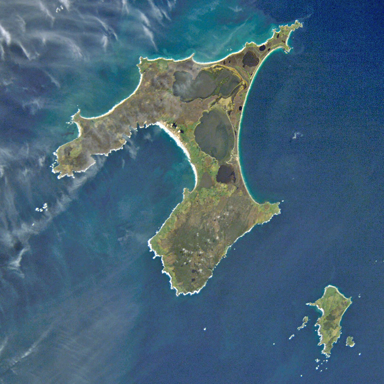 Chatham Island (left) from space | |
 Map showing location of Chatham Island | |
| Geography | |
| Coordinates | 43°54′S 176°29′W |
| Archipelago | Chatham Islands |
| Area | 920 km2 (360 sq mi) |
| Administration | |
New Zealand | |
| Demographics | |
| Population | 660 (2022) |
| Ethnic groups | Moriori |
The island was named after the survey ship HMS Chatham which was the first European ship to locate the island in 1791.[2] It covers an area of 920 square kilometres (355 sq mi).[3] Chatham Island lies 650 km (404 mi) south-east of Cape Turnagain, the nearest point of mainland New Zealand to the island.
Geography

The geography of the roughly T-shaped island is dominated by three features: two bays and a lagoon. More than half of the west coast of Chatham is taken up by the deep indentation of Petre Bay. The island's main settlement of Waitangi is located in a small indentation in Petre Bay's southern coast. Other significant settlements are Kaingaroa on the northeast promontory, and Owenga on the south side of Hanson Bay.
On the east coast is the even larger Hanson Bay, which stretches for the entire length of the island (35 kilometres (22 mi)).[4]
Much of the area between the bays is taken up by the large Te Whanga Lagoon, which drains to the sea to the east, into the southern half of Hanson Bay. This lagoon covers about 160 square kilometres (62 sq mi),[5] and drains several small rivers that rise in the hills at the south end of the island. The next largest lakes are Rangitahi and Huro, respectively northeast and southwest of Te Whanga.[6] The central and north part of Chatham Island are mostly flat, with altitudes ranging from a few metres on the northeast and centre to 50 m on the northwest, but with a few scattered hillocks.[6] The south part is higher, generally sloping down towards north and west; about half of it is over 150 m above sea level. The south coast of the island is mostly cliffs 100 m high or more. The highest point of the island (299 m) lies close to its southernmost point.[6]

Flora and fauna
Chatham Island hosts the only known breeding populations of the endemic and critically endangered Magenta petrel.
In popular culture
Chatham Island (or "Isle") is featured in the first and in the final chapter of Cloud Atlas, the 2004 novel by David Mitchell. The novel was adapted for screen in 2012.[7]
See also
- Chatham Standard Time Zone
- List of islands of New Zealand
References
- Government of New Zealand, Dept. of Conservation (1999) Chatham IslandsConservation Management Strategy Archived 7 June 2011 at the Wayback Machine. Retrieved 13 July 2012.
- Steven Hooper (30 July 2006). Pacific Encounters: Art & Divinity in Polynesia 1760-1860. University of Hawaii Press. p. 119. ISBN 978-0-8248-3084-7. Retrieved 17 July 2012.
- "Story: Chatham Islands Page 1 – Overview". web page. The Encyclopedia of New Zealand. 7 September 2012. Retrieved 15 December 2012.
- Ross Curtis (2011). "Chatham Island Wildlife & Landscapes". web page. Ross Curtis. Archived from the original on 18 October 2019. Retrieved 14 December 2012.
- "Te Whanga Lagoon". web page. The Encyclopedia of New Zealand. 7 September 2012. Retrieved 15 December 2012.
- Chatham Island, NZ Topo Map. Retrieved 14 July 2012.
- Walsh, David (2 November 2012). "Cloud Atlas: Six stories in search of a genuine connection". Retrieved 19 November 2012.
| Islands (by English name) |
|  |
|---|---|---|
| Islands (by Māori/Moriori name) |
| |
| Coastal landforms |
| |
| Populated places |
| |
| Other geographic features |
| |
| Historical events |
| |
На других языках
[de] Chatham Island
Chatham Island (Moriori: Rekohu; Māori: Wharekauri) ist die größte Insel im Archipel der zu Neuseeland gehörenden Chatham-Inseln im südwestlichen Pazifik.- [en] Chatham Island
[es] Isla Chatham
La isla Chatham es la más grande del grupo de Islas Chatham, en el océano Pacífico sur frente a la costa oriental de Nueva Zelanda (no exactamente “a mitad de camino entre el ecuador y el polo, y justo sobre la línea internacional de cambio de fecha” pero lo suficientemente cerca para los propósitos publicitarios). Está situada a 43°53′54″S 176°31′44″O. Fue bautizada en honor al survey ship HMS Chatham, el cual descubrió la isla en 1791. Tiene una superficie de 900 km².[fr] Île Chatham (Nouvelle-Zélande)
L'île Chatham (en maori de Nouvelle-Zélande : Wharekauri, en moriori : Rekohu) est une île de Nouvelle-Zélande située à environ 800 kilomètres à l'est de l'île du Sud, dans l'océan Pacifique Sud. Elle fait partie de l'archipel des îles Chatham dont elle est l'île la plus grande et la plus peuplée.[it] Isola Chatham
L'isola Chatham è di gran lunga la maggiore isola dell'arcipelago omonimo, situato nel Pacifico meridionale, al largo delle coste orientali della Nuova Zelanda; è posta a metà strada tra l'Equatore e il polo, nei pressi della linea internazionale del cambio di data. L'isola, così come l'arcipelago, deve il nome alla nave britannica Chatham, che la individuò per la prima volta nel 1791. Si estende su un'area di 347 km².[ru] Чатем (остров)
Ча́тем (или Рекоху) (англ. Chatham, маори Rekohu) — крупнейший остров одноимённого архипелага. Географические координаты острова: 43°53′ ю. ш. 176°31′ з. д.HGЯO.Другой контент может иметь иную лицензию. Перед использованием материалов сайта WikiSort.org внимательно изучите правила лицензирования конкретных элементов наполнения сайта.
WikiSort.org - проект по пересортировке и дополнению контента Википедии