geo.wikisort.org - Island
Bathurst Island (Iwaidja: Nguyu)[1] (2,600 km2 or 1,000 sq mi,[2] 11°35′S 130°18′E) is one of the Tiwi Islands in the Northern Territory off the northern coast of Australia along with Melville Island.
Native name: Nguyu | |
|---|---|
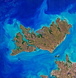 Satellite image of the Tiwi Islands, Melville (top right) and Bathurst (left) with the Australian mainland (bottom right) | |
Bathurst Island Bathurst Island (Northern Territory of Australia) | |
| Geography | |
| Location | Timor Sea |
| Coordinates | 11°35′S 130°18′E |
| Archipelago | Tiwi Islands |
| Major islands | Bathurst, Buchanan |
| Area | 2,600 km2 (1,000 sq mi) |
| Administration | |
Australia | |
| Territory | Northern Territory |
| Largest settlement | Wurrumiyanga (pop. 1563) |
| Demographics | |
| Population | ca. 1640 |
| Pop. density | 0.63/km2 (1.63/sq mi) |
Description
The largest settlement on Bathurst is Wurrumiyanga (known as Nguiu until 2010), in the south-east, with a population of around 1,560.[3][4] Located on the south east corner of Bathurst Island, Wurrumiyanga is approximately 70 km (43 mi) north of Darwin. The second largest settlement is Wurakuwu, with a population of 50, located 60 km (37 mi) northwest of Wurrumiyanga. The third settlement on the island is a small family outstation called 4 Mile Camp, about 6 km (3.7 mi) west of Wurrumiyanga.
History
Aboriginal Australians have occupied the area that became the Tiwi Islands for at least 40,000 years.[5]
On 5 May 1623, Willem Jootszoon Van Colster (or Coolsteerdt), in the ship Arnhem named the island De Speult Eylandt, in honour of Herman van Speult, Governor of Ambon, who had commissioned the voyage of exploration.[6]
In 1828, the island was named Bathurst Island by Scottish explorer John Clements Wickham, after the explorer Phillip Parker King's ship which had explored the area in August 1821. He named the island during a voyage in March 1838 when he was second in command of HMS Beagle in Charles Darwin's expedition. The ship's name honours Henry Bathurst, 3rd Earl Bathurst, (1762-1834), former British Secretary of State for the Colonies.
From 1910 to 1938 the island was the site of the Roman Catholic mission of Francis Xavier Gsell, known as the "Bishop with 150 wives" for his practice of "buying" girls betrothed to older men, thus making it possible for them to marry men of their own age.[citation needed]
On 24 December 1912 the whole island was proclaimed an Aboriginal reserve, under the Northern Territory Aboriginals Act 1910. A series of documents show that previous to the proclamation (published in the Commonwealth Gazette on 18 January 1913), there had been discussion about two parcels of land on the island. One was the allocation of 10,000 acres (4,000 ha) allocated to the Mission, which would continue on annual leases, and the second regarding 10,000 acres (4,000 ha) which was previously allocated as Crown Land under the Northern Territory Tropical Products Act 1904, for the production of cotton and other tropical crops. The correspondence shows that this was decided to be undesirable from the point of view of the Aboriginal people, both because of the bad influence of white men and the need to import labour to use on the leases.[7]
Before the bombing of Darwin, a Missionary of the Sacred Heart priest, Ed Bennett, saw the approaching Japanese bombers, and urged the resident coastwatcher, John Gribble, to send a warning to Darwin, but Gribble refused. He said it would have to be sent in code, and he did not have the relevant code books.[8][9] The first wave of 188 Japanese planes was also spotted by another missionary on the island, Father John McGrath, who sent a message on the radio saying "An unusually large air formation bearing down on us from the northwest". However, ten US P-40E Kittyhawk fighters were returning to Darwin after aborting a mission to Timor due to bad weather,[10] and the Australian duty officer assumed this was the same formation, and the warning was not acted upon.
In film
Bathurst Island was depicted as Mission Island in the 2008 Baz Luhrmann film Australia. In the film, Japanese infantrymen land on the island; however, the presence of Japanese troops on the island is entirely fictional, as no such landing by the Japanese was made during World War II.[9]
Notable people
- Olive May Pearce
Notes and references
- "Iwaidja - Categories".
- "Size change". Encyclopædia Britannica entry on Bathurst island supporting size.
- "2016 Census QuickStats: Wurrumiyanga". quickstats.censusdata.abs.gov.au. Retrieved 5 August 2020.
- "Nguiu". Tiwi Islands Local Government website. Archived from the original on 9 December 2004.
- "Timeline: Dreamtime to 1978". Tiwi Land Council. Retrieved 4 February 2020.
- "Beyond Darwin: Tiwi Islands". Pocket Oz Travel and Information Guide: Darwin. Retrieved 4 February 2020.
- "Bathurst Island - Reserve for Aborigines.[56pp] (1904-1939)". National Archives of Australia. Record search on item barcode 46584, Control symbol 1938/33126, Citation NAA: A1, 1938/33126. Retrieved 4 February 2020.
{{cite web}}: CS1 maint: others (link) - "Brother who tried to warn Darwin dead". CathNews. 12 December 2008. Retrieved 20 February 2021.
- Willson, Robert (18 April 2014). "The Darwin raid that changed Australia". The Sydney Morning Herald. Review of Carrier Attack: Darwin 1942 (2013), by Tom Lewis and Peter Ingman. Retrieved 20 February 2021.
- "The Bombing of Darwin". The Battle for Australia 1942. 19 February 1942. Retrieved 4 February 2020.
Further reading
- "Bathurst Island Mission 1911-1938-1978)". German missionaries in Australia. Griffith University.
- "Bathurst Island Mission (1911-1974)". Find and Connect.
- Bathurst island (Encyclopædia Britannica)
- Bathurst Island (Walkabout)
External links
Authority control | |
|---|---|
| General |
|
| National libraries | |
Islands of the Northern Territory | |
|---|---|
|
На других языках
[de] Bathurst Island (Australien)
Bathurst Island ist eine australische Insel abseits der nördlichen Küste des Northern Territory.- [en] Bathurst Island (Northern Territory)
[es] Isla de Bathurst (Australia)
La isla Bathurst (2,600 km² , 11°35′S 130°18′E) es una de las Islas Tiví, una de las más grandes, ubicada cerca del Territorio del Norte de la costa norte de Australia junto con la Isla Melville.[fr] Île Bathurst (Australie)
L'Île Bathurst est une île australienne de la mer de Timor située au nord de Darwin, dans le Territoire du Nord. Une distance de 58 km sépare la pointe sud-est de l'île de Gunn Point, sur la côte continentale. Bathurst fait partie des îles Tiwi tout comme l'île Melville dont elle est séparée par le détroit de Apsley, un passage large de 1 km à 5 km pour une longueur de 64 km.[it] Isola Bathurst (Australia)
Bathurst è un'isola dell'Australia appartenente all'arcipelago delle isole Tiwi e situata a nord delle coste del Territorio del Nord. L'isola, affiancata ad est dall'isola Melville, si trova tra il mar di Timor, a ovest, e il mare degli Arafura a nord. Il principale centro abitato di Bathurst è Wurrumiyanga (conosciuto come Nguiu fino al 2010), che si trova a sud-est e conta una popolazione di circa 2500 abitanti[2]; un altro centro è Wurakuwu, situato a nord-ovest.[ru] Батерст (остров, Австралия)
Остров Ба́терст (англ. Bathurst Island) — остров на востоке Тиморского моря, принадлежит Северной территории Австралии.Другой контент может иметь иную лицензию. Перед использованием материалов сайта WikiSort.org внимательно изучите правила лицензирования конкретных элементов наполнения сайта.
WikiSort.org - проект по пересортировке и дополнению контента Википедии