geo.wikisort.org - Island
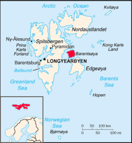
Barentsøya, sometimes anglicized as Barents Island, is an island in the Svalbard archipelago of Norway, lying between Edgeøya and Spitsbergen. Barents Island has no permanent human inhabitants. Named for the Dutch explorer Willem Barents (who actually never sighted the island), it is a part of Søraust-Svalbard Nature Reserve.[1]
 | |
| Geography | |
|---|---|
| Location | Arctic Ocean |
| Coordinates | 78°25′N 21°27′E |
| Archipelago | Svalbard |
| Area | 1,288 km2 (497 sq mi) 558 km2 (215 sq mi) glaciated. |
| Coastline | 205 km (127.4 mi) |
| Highest elevation | 666 m (2185 ft) |
| Highest point | Solveigdomen |
| Administration | |
Norway | |
| Demographics | |
| Population | 0 |
Barentsøya is an Arctic island. Around 43 per cent of its area of 1,288 square kilometres (497 sq mi) is glaciated. To the north, in the sound between Barentsøya and Spitsbergen, lies the island of Kükenthaløya. To the south, the sound separating Barents Island from Edgeøya is Freemansundet.
In geologic time much of the surface rock has been eroded by glaciation.[2] The entire area is visited by polar bears, who have a recognisable genetic differentiation specialised to the Barents Sea region. At Dørstubukta there is also a large nesting mainly used by kittiwakes.[3]
Geography

Barentsøya has an approximately square shape, with maximum lengths and widths of about fifty kilometers,[4] and an area of 1,288 km2 (497 sq mi). A significant part of the island, more than 500 km2 (190 sq mi), is glaciated. The ice cap of Barentsjøkulen covers a large part of the island, with the largest offspring Besselsbreen (north), Duckwitzbreen (west), Freemanbreen (south), and Hübnerbreen (southeast).[5][6][7][8][9] Barentsjøkulen has the two large ice domes of Peer Gyntslottet and Solveigdomen.[10][11] The mountain of Schweinfurthberget is a nunatak of Barentsjøkulen.[12]
At the northern side of Barentsøya is the ice-free peninsula of Frankenhalvøya, between Ginevra Bay at the western side and Dorstbukta to the east.[13][14] Grimheia is an ice-free mountainous area extending over a length of about thirteen kilometers at the northern part of the island.[15] The westernmost point of the island is the headland of Mistakodden.[16] At the southern part of Barentsøya are the mountains of Krefftberget and Høgrinden, while Jeppeberget is located to the southeast.[17][18][19] The largest lakes of the island are Veslemjøsa in Heimarka, and Dalskilvatnet between the valleys of Sjodalen and Grimdalen.[20][21]

See also
References
- Susan Barr. "Barentsøya". Store norske leksikon. Retrieved November 1, 2016.
- Svalbard Images
- C. Michael Hogan, 2008
- "Barentsøya (Svalbard)". Norwegian Polar Institute. Retrieved 12 February 2015.
- "Barentsjøkulen (Svalbard)". Norwegian Polar Institute. Retrieved 12 February 2015.
- "Besselsbreen (Svalbard)". Norwegian Polar Institute. Retrieved 12 February 2015.
- "Duckwitzbreen (Svalbard)". Norwegian Polar Institute. Retrieved 12 February 2015.
- "Freemanbreen (Svalbard)". Norwegian Polar Institute. Retrieved 12 February 2015.
- "Hübnerbreen (Svalbard)". Norwegian Polar Institute. Retrieved 12 February 2015.
- "Peer Gyntslottet (Svalbard)". Norwegian Polar Institute. Retrieved 12 February 2015.
- "Solveigdomen (Svalbard)". Norwegian Polar Institute. Retrieved 12 February 2015.
- "Schweinfurthberget (Svalbard)". Norwegian Polar Institute. Retrieved 12 February 2015.
- "Frankenhalvøya (Svalbard)". Norwegian Polar Institute. Retrieved 12 February 2015.
- "Dorstbukta (Svalbard)". Norwegian Polar Institute. Retrieved 12 February 2015.
- "Grimheia (Svalbard)". Norwegian Polar Institute. Retrieved 12 February 2015.
- "Mistakodden (Svalbard)". Norwegian Polar Institute. Retrieved 12 February 2015.
- "Krefftberget (Svalbard)". Norwegian Polar Institute. Retrieved 12 February 2015.
- "Høgrinden (Svalbard)". Norwegian Polar Institute. Retrieved 12 February 2015.
- "Jeppeberget (Svalbard)". Norwegian Polar Institute. Retrieved 12 February 2015.
- "Veslemjøsa (Svalbard)". Norwegian Polar Institute. Retrieved 12 February 2015.
- "Dalskilvatnet (Svalbard)". Norwegian Polar Institute. Retrieved 12 February 2015.
Line notes
- C. Michael Hogan (2008) Polar Bear: Ursus maritimus, globalTwitcher.com, ed. Nicklas Stromberg
External links
- Svalbard Images: Barentsøya (URL accessed 26 December 2008)
На других языках
[de] Barentsøya
Barentsøya (deutsch Barentsinsel) ist die viertgrößte Insel des zu Norwegen gehörenden Spitzbergen-Archipels (Svalbard) im Arktischen Ozean. Sie liegt östlich der Insel Spitzbergen (der Hauptinsel des Archipels) und nördlich der etwas größeren Insel Edgeøya. Barentsøya hat eine Fläche von 1288 km² und ist 50 Kilometer lang und 50 Kilometer breit.[1] Die Insel ist unbewohnt.- [en] Barentsøya
[fr] Barentsøya
Barentsøya ou île de Barents est une île faisant partie de l'archipel du Svalbard et dépendant donc de la Norvège. Elle est la quatrième île norvégienne la plus grande et porte le nom de l'explorateur néerlandais Willem Barentsz, qui, s'il a découvert le Svalbard, n'a par ailleurs jamais vu l'île.[it] Barentsøya
Barentsøya è un'isola disabitata situata nell'arcipelago norvegese delle isole Svalbard, si trova tra le isole di Edgeøya e di Spitsbergen.[ru] Остров Баренца
О́стров Ба́ренца (норв. Barentsøya) — необитаемый остров в составе архипелага Шпицберген. Расположен в восточной части архипелага, между островами Эдж и Западный Шпицберген. При площади в 1288 км², остров Баренца является четвёртым по величине в архипелаге. Назван в честь голландского исследователя и мореплавателя В. Баренца.Другой контент может иметь иную лицензию. Перед использованием материалов сайта WikiSort.org внимательно изучите правила лицензирования конкретных элементов наполнения сайта.
WikiSort.org - проект по пересортировке и дополнению контента Википедии