geo.wikisort.org - Coast
The Vistula Spit (Polish: Mierzeja Wiślana; Russian: Балтийская коса; German: Frische Nehrung) is an aeolian sand spit,[1] or peninsular stretch of land that separates Vistula Lagoon from Gdańsk Bay, in the Baltic Sea, with its tip separated from the mainland by the Strait of Baltiysk. The border between Poland (Pomeranian Voivodeship) and Kaliningrad Oblast, a semi-exclave of Russia, bisects it, politically dividing the spit in half between the two countries. The westernmost geographical point of Russia is located on the Vistula Spit. The Polish part contains a number of tourist resorts, incorporated administratively as the town of Krynica Morska.
Vistula Spit | |
|---|---|
Spit | |
 Landsat photo of the Vistula Spit | |
Vistula Spit  Vistula Spit  Vistula Spit 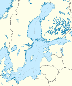 Vistula Spit | |
| Coordinates: 54°24′N 19°30′E | |
| Location | Pomeranian Voivodeship, Poland Kaliningrad Oblast, Russia |
| Offshore water bodies | Gdańsk Bay Vistula Lagoon |
| Dimensions | |
| • Length | 70 km (43 mi) |
| Largest town | Krynica Morska |
Geography
Situated in the Gdańsk Bay this narrow headland (spit) is on average only few hundred meters wide (widest point is 1.8 km (1.1 mi)) and with the total length of 70 km (43 mi) twice as long as the better known and more populous Hel Peninsula in the western part of the Gdańsk Bay. The Vistula Spit stretches in a north-easterly direction and separates the Vistula Lagoon from the southern Baltic Sea. It is separated from the Sambia Peninsula by the Strait of Baltiysk. The spit consists of 10 to 12 meter high marine sand, accumulated during three dune generations.[2] The highest peaks of the Vistula Spit are Wielbłądzi Grzbiet (49.5 m, 162 ft) on the Polish side of the peninsula and the smaller 25 m (82 ft) high shifting sand dune of Narmeln on the Russian side of the border.[3]
The border between Poland (Pomeranian Voivodeship) and Russia (Kaliningrad Oblast) runs across the spit, with its south-western part in Poland and the north-eastern part in Russia. The Polish part includes, from west to east, the villages of Kąty Rybackie, Skowronki, and the town of Krynica Morska, the largest locality on the Polish side, and a popular tourist destination. Since 1991, Krynica Morska includes in its municipal borders formerly separate villages of Przebrno and Nowa Karczma, the latter being the easternmost inhabited locality on the Polish side of the Spit.[4][5]
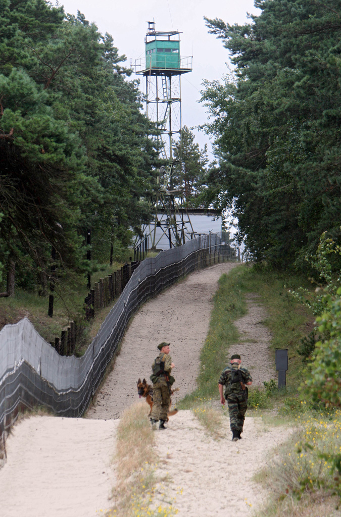
The Russian part of the Vistula Spit is only inhabited in its northernmost part, which belongs to the port town of Baltiysk and lies on the southern side of the Strait of Baltiysk. The Russian airbase Noytif (originally built as a German Luftwaffe airbase Neu Tief) is located there and inhabited by around 1,000 people and personnel. It can be reached by ferry from the Baltiysk core area on the other side of the Strait.[6]
History
This article needs additional citations for verification. (August 2010) |
Until the 13th century, the spit had navigable straits in the middle, which allowed the city of Elbing (Elbląg), part of the monastic State of the Teutonic Knights, direct access to the Baltic Sea. The natural closing of the straits in the late 13th century reduced Elbing's status as an important trading seaport. This and the Teutonic takeover of Danzig (Gdańsk) and Polish Pomerania in 1308 led to the increased importance of Gdańsk. In 1454, King Casimir IV Jagiellon re-incorporated the region to the Kingdom of Poland upon the request of the anti-Teutonic Prussian Confederation.[7] In 1466, the Teutonic Knights renounced any claims to the region and recognized it as part of Poland.[8]
During World War II, Przebrno was the location of a subcamp of the Stutthof concentration camp, in which the Germans imprisoned 200 people as forced labour at a time.[9] There is a momument to the victims at the site. In the final stages of the war, the spit became the last holdout of the remaining German soldiers in the province of East Prussia, although the Soviets simply bypassed the spit after the East Prussian Offensive was decisively concluded, training their sights on the more important goal of capturing Berlin. The last Wehrmacht soldiers laid down their arms after the German Instrument of Surrender was signed.
Kursenieki
Historically Vistula Spit was populated by Kursenieki people (also known as Kuršininkai), an Old Prussian tribe, related to modern day Latvians. This nearly extinct Baltic ethnic group once made Vistula Spit, costal zone of the Sambia Peninsula, and the Curonian Spit their home. In 1649 the Kuršininkai zone of settlement still spanned all the way from Memel (Klaipėda) to Gdańsk encompassing a narrow littoral strip of territory best suitable for their lifestyle, cultural preferences and dominant economic activity (fishing). The majority of Kuršininkai were eventually assimilated by the Germans. Only on the Curonian Spit a few scattered rural settlements survive to the present day. The Kuršininkai were considered Latvians until after World War I when Latvia gained independence from the Russian Empire, a consideration based on linguistic arguments. This was also the rationale for Latvian claims over the Curonian Spit, Memel, and other territories of Prussia in the aftermath of the WWI. Those claims would later be dropped.
Transport

The Polish side of the peninsula is accessible using Voivodeship road 501. There is at present (2016) no border crossing between Poland and Russia on the peninsula.
Vistula Spit canal
In 2019, the Polish government started the building of a ship canal across the peninsula, which will permit ships to enter the Vistula Lagoon and the port of Elbląg, bypassing the current transit route through the Russian Strait of Baltiysk.[10] The canal was opened in September 2022.
References
- Kramarska, R Uścinowicz, S Zachowicz J and Kawińska M, Origin and evolution of the Puck Lagoon in Journal of Coastal Research Issue 22, 2005, P187
- Eric Bird (25 February 2010). Encyclopedia of the World's Coastal Landforms. Springer Science & Business Media. pp. 633–. ISBN 978-1-4020-8638-0.
- "Wegen Kaliningrad: Polen baggert eigenen Ostseekanal". MDR. September 11, 2017. Retrieved September 19, 2020.
- Wolfgang Albrecht Stromer von Reichenbach (1676). Speculum Germaniae oder ein kurtzer geographischer Bericht von dem gesammaten Teutschland. pp. 4–.
- "Rozporządzenie Rady Ministrów z dnia 22 grudnia 1990 r. w sprawie utworzenia, zniesienia, zmiany granic, nazw i ustalenia siedzib niektórych gmin w województwach: bielskim, bydgoskim, elbląskim, gdańskim, katowickim, kieleckim, krośnieńskim, nowosądeckim i siedleckim oraz nadania statutu miasta". isap.sejm.gov.pl. Retrieved 2021-06-04.
- Gerald Schernewski (13 May 2002). Baltic Coastal Ecosystems: Structure, Function and Coastal Zone Management. Springer Science & Business Media. pp. 134–. ISBN 978-3-540-42937-1.
- Górski, Karol (1949). Związek Pruski i poddanie się Prus Polsce: zbiór tekstów źródłowych (in Polish). Poznań: Instytut Zachodni. pp. 51, 56.
- Górski, pp. 88-90, 206-207
- Gliński, Mirosław. "Podobozy i większe komanda zewnętrzne obozu Stutthof (1939–1945)". Stutthof. Zeszyty Muzeum (in Polish). 3: 166–167. ISSN 0137-5377.
- RDLP: wycinka na Mierzei Wiślanej jest zakończona
External links
- Vistula Spit (in Polish and German)
- Russia's Strategic Strip Of Sand and Sea Faces Tourist Assault on YouTube, Radio Free Europe/Radio Liberty, published on Mar 28, 2019

Authority control | |
|---|---|
| General |
|
| National libraries | |
На других языках
[de] Frische Nehrung
Die Frische Nehrung (polnisch Mierzeja Wiślana „Weichsel-Nehrung“, russisch Балтийская коса .mw-parser-output .Latn{font-family:"Akzidenz Grotesk","Arial","Avant Garde Gothic","Calibri","Futura","Geneva","Gill Sans","Helvetica","Lucida Grande","Lucida Sans Unicode","Lucida Grande","Stone Sans","Tahoma","Trebuchet","Univers","Verdana"}Baltijskaja Kossa „Baltische Nehrung“) ist eine schmale Landzunge (Nehrung) von rund 70 km Länge und einigen hundert Metern Breite (größte Breite 1,8 km), die in nordöstlicher Richtung verläuft und das Frische Haff von der offenen Ostsee (Danziger Bucht) abtrennt. Damit ist die Frische Nehrung mehr als doppelt so lang wie die bevölkerungsreichere Halbinsel Hel. Quer über die Frische Nehrung verläuft die Grenze zwischen Polen (Woiwodschaft Pommern) und Russland (Oblast Kaliningrad).- [en] Vistula Spit
[es] Cordón del Vístula
El cordón del Vístula (en polaco, Mierzeja Wiślana; en ruso, Балтийская коса; en alemán, Frische Nehrung) es un cordón litoral o gran barra arenosa que divide la laguna del Vístula de la bahía de Gdansk. Esta estrecha península está dividida entre Polonia (voivodatos de Pomerania y Varmia y Masuria) y Rusia (óblast de Kaliningrado).[ru] Балтийская коса
Балтийская коса[1][2], в Польше — Вислинская коса[1] (польск. Mierzeja Wiślana), до 1945 года — Фрише-Нерунг[3] (нем. Frische Nehrung) — узкая полоска суши (коса), отделяющая Калининградский залив от основной части Гданьского залива[2].Другой контент может иметь иную лицензию. Перед использованием материалов сайта WikiSort.org внимательно изучите правила лицензирования конкретных элементов наполнения сайта.
WikiSort.org - проект по пересортировке и дополнению контента Википедии