geo.wikisort.org - Coast
Coron, officially the Municipality of Coron (Tagalog: Bayan ng Coron), is a 1st class municipality in the province of Palawan, Philippines. According to the 2020 census, it has a population of 65,855 people. [3]
Coron | |
|---|---|
Municipality | |
| Municipality of Coron | |
 Coron skyline | |
 Flag | |
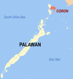 Map of Palawan with Coron highlighted | |
OpenStreetMap  | |
 Coron Location within the Philippines | |
| Coordinates: 12°00′N 120°12′E | |
| Country | Philippines |
| Region | Mimaropa |
| Province | Palawan |
| District | 1st district |
| Founded | 1902 |
| Barangays | 23 (see Barangays) |
| Government | |
| • Type | Sangguniang Bayan |
| • Mayor | Mario T. Reyes Jr. |
| • Vice Mayor | Asian Manasseh Lorenzo A. Palanca |
| • Representative | Edgardo L. Salvame |
| • Municipal Council | Members |
| • Electorate | 32,894 voters (2019) |
| Area | |
| • Total | 689.10 km2 (266.06 sq mi) |
| Elevation | 8.0 m (26.2 ft) |
| Highest elevation | 957 m (3,140 ft) |
| Lowest elevation | 0 m (0 ft) |
| Population | |
| • Total | 65,855 |
| • Density | 96/km2 (250/sq mi) |
| • Households | 11,463 |
| Economy | |
| • Income class | 1st municipal income class |
| • Poverty incidence | 17.06% (2018)[4] |
| • Revenue | ₱354,972,473.90 (2020) |
| • Assets | ₱834,241,000.22 (2020) |
| • Expenditure | ₱281,477,963.60 (2020) |
| • Liabilities | ₱233,253,777.21 (2020) |
| Service provider | |
| • Electricity | Busuanga Island Electric Cooperative (BISELCO) |
| Time zone | UTC+8 (PST) |
| ZIP code | 5316 |
| PSGC | |
| IDD : area code | +63 (0)48 |
| Native languages | Calamian Tagbanwa Kagayanen Palawano Tagalog |
The main population center of the municipality is composed of Poblacion barangays 1 to 6, where the Municipal Building, the Municipal Legislative Building, and the Judicial Hall of the Municipal Circuit Trial Court are located. Its fiesta is held annually on August 28 in honor of Saint Augustine. It is the commercial capital of the Calamian Islands.
The municipality is home to the Coron Island Natural Biotic Area, which is listed in the natural category of the UNESCO World Heritage Tentative List.[5]
History
The Calamianes Islands were originally inhabited by the Tagbanuas, Calmiananen, and Cuyonon tribes.
Oral history tells that the Datu Macanas ruled the entire Busuanga Island where present-day Coron town lies. Early on Spanish exploration of the islands, Fray de la Concepcion took note of the friendliness of the people of Busuanga Island and the ferocity of the Tagbanua tribe living in Coron Island.
In this area of the Calamianes, the first permanent Spanish settlement was Culion. Coron was a mere visita of Culion at that time. A fort and church were built in Libis, Culion around 1670 by the Spaniards as part of the defenses (along with Cuyo, Taytay, and Linapacan) against the Muslim raids. This became a settlement for migrants to the Calamianes. Don Nicolas Manlavi a Cuyonon served several years in Spanish Galleons, and an Ilonggo from Jaro, Ilo-ilo named Claudio Sandoval later wed Nicolas' only daughter Evarista. The Sandoval clan of the Calamianes came from this union. It was Don Nicolas Manlavi who established the first settlement in Coron which was initially at Banuang Lague (old town) in present-day Banuang Daan in Coron Island. The town center was then again moved to present-day Maquinit and later on, it was finally established in present-day Bancuang in Barangay 5 where a good water source was found. [citation needed]
Late in the 1890s, an American naturalist, Dean Worcester, journeyed through the Calamianes collecting specimens and stayed briefly in Culion. At the turn of the century, he was appointed part of the First Philippine Commission, becoming the Secretary of the Interior. He recommended Culion as the Philippine Leper Colony. This act forced the transfer of the Sandoval clan in 1900 to the various barrios of what is now Coron and Busuanga. The Coron town was settled by the family of Claudio Sandoval, and the other Sandovals settled in what is now Bintuan, Salvacion, Concepcion, and Old Busuanga.
In 1950, the town of Busuanga was created from the barrios of Concepcion, Salvacion, Busuanga, New Busuanga, Buluang, Quezon, Calawit, and Cheey which used to belong to Coron.[6] In 1954, the islands of Linapacan, Cabunlaoan, Niangalao, Decabayotot, Calibanbangan, Pical, and Barangonan were separated from Coron to form the town of Linapacan.[7]
Geography
The municipality of Busuanga comprises the western part of Busuanga Island, while Coron comprises the eastern part of Busuanga Island, all of Coron Island and about 50 other minor islets stretching as far as Tara Island in the north-east and Canipo Island in the south.[8] All these islands are part of the Calamian Archipelago in northern Palawan that separates the South China Sea from the Sulu Sea.
Barangays
Coron is politically subdivided into 23 barangays.
- Banuang Daan
- Bintuan
- Borac
- Buenavista
- Bulalacao
- Cabugao
- Decabobo
- Decalachao
- Guadalupe (also called Binalabag)
- Lajala
- Malawig
- Marcilla
- Barangay I (Poblacion)
- Barangay II (Poblacion)
- Barangay III (Poblacion)
- Barangay IV (Poblacion)
- Barangay V (Poblacion)
- Barangay VI (Poblacion)
- San Jose
- San Nicolas
- Tagumpay
- Tara
- Turda
Climate
| Climate data for Coron, Palawan (1981–2010, extremes 1950–2012) | |||||||||||||
|---|---|---|---|---|---|---|---|---|---|---|---|---|---|
| Month | Jan | Feb | Mar | Apr | May | Jun | Jul | Aug | Sep | Oct | Nov | Dec | Year |
| Record high °C (°F) | 36.4 (97.5) |
36.1 (97.0) |
37.4 (99.3) |
37.6 (99.7) |
37.6 (99.7) |
36.5 (97.7) |
35.7 (96.3) |
34.7 (94.5) |
34.6 (94.3) |
36.6 (97.9) |
37.0 (98.6) |
35.2 (95.4) |
37.6 (99.7) |
| Average high °C (°F) | 32.4 (90.3) |
32.6 (90.7) |
33.2 (91.8) |
34.0 (93.2) |
33.4 (92.1) |
31.7 (89.1) |
30.9 (87.6) |
30.9 (87.6) |
31.1 (88.0) |
31.8 (89.2) |
32.5 (90.5) |
32.3 (90.1) |
32.2 (90.0) |
| Daily mean °C (°F) | 27.5 (81.5) |
27.8 (82.0) |
28.4 (83.1) |
29.1 (84.4) |
28.9 (84.0) |
27.8 (82.0) |
27.1 (80.8) |
27.2 (81.0) |
27.3 (81.1) |
27.7 (81.9) |
28.1 (82.6) |
27.8 (82.0) |
27.9 (82.2) |
| Average low °C (°F) | 22.7 (72.9) |
22.9 (73.2) |
23.6 (74.5) |
24.3 (75.7) |
24.4 (75.9) |
23.9 (75.0) |
23.4 (74.1) |
23.4 (74.1) |
23.5 (74.3) |
23.5 (74.3) |
23.6 (74.5) |
23.2 (73.8) |
23.5 (74.3) |
| Record low °C (°F) | 12.2 (54.0) |
13.3 (55.9) |
13.4 (56.1) |
14.0 (57.2) |
18.1 (64.6) |
17.6 (63.7) |
17.1 (62.8) |
17.0 (62.6) |
17.4 (63.3) |
17.2 (63.0) |
16.1 (61.0) |
14.7 (58.5) |
12.2 (54.0) |
| Average rainfall mm (inches) | 18.5 (0.73) |
14.0 (0.55) |
15.4 (0.61) |
38.1 (1.50) |
198.1 (7.80) |
360.8 (14.20) |
479.9 (18.89) |
466.3 (18.36) |
447.1 (17.60) |
250.8 (9.87) |
118.6 (4.67) |
74.0 (2.91) |
2,481.7 (97.70) |
| Average rainy days (≥ 0.1 mm) | 3 | 2 | 2 | 3 | 12 | 19 | 23 | 22 | 21 | 17 | 9 | 6 | 139 |
| Average relative humidity (%) | 80 | 79 | 78 | 77 | 81 | 87 | 88 | 88 | 88 | 87 | 83 | 82 | 83 |
| Source: PAGASA[9][10] | |||||||||||||
Demographics
|
| |||||||||||||||||||||||||||||||||||||||||||||||||||
| Source: Philippine Statistics Authority [11] [12] [13][14] | ||||||||||||||||||||||||||||||||||||||||||||||||||||
In the 2020 census, the population of Coron, Palawan, was 65,855 people, [3] with a density of 96 inhabitants per square kilometre or 250 inhabitants per square mile.
Economy

The main industries of Coron are fishing and tourism.[citation needed] Former industries include manganese mining at Singay Mines in Barangay San Nicolas during the Japanese Occupation period. This was followed by the fishing industry boom during the 1970s up to the 1990s which gradually dwindled due to illegal blast and sodium cyanide fishing. The rattan and basket-weaving industry which also gradually declined during the same period due to the ensuing depletion of raw materials.
Currently tourism is the top industry in Coron due to local beaches, dive sites, and other natural tourist spots. A dozen sunken Japanese warships at depths between 10 and 40 meters (33 and 131 ft) off Coron Island is a diving destination,[8] listed in Forbes Traveler Magazine’s top 10 best scuba diving sites in the world.[citation needed] A description of the diving highlights in 2021 is provided by Dive the World.[22]
Transportation
The Francisco B. Reyes Airport serves the town.
Gallery
 Church in Coron
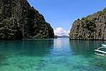
 The lagoon going to Kayangan Lake
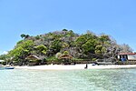 Waling Waling Island, Coron, Palawan


References
- Municipality of Coron | (DILG)
- "2015 Census of Population, Report No. 3 – Population, Land Area, and Population Density" (PDF). Philippine Statistics Authority. Quezon City, Philippines. August 2016. ISSN 0117-1453. Archived (PDF) from the original on May 25, 2021. Retrieved July 16, 2021.
- Census of Population (2020). "MIMAROPA". Total Population by Province, City, Municipality and Barangay. PSA. Retrieved 8 July 2021.
- "PSA Releases the 2018 Municipal and City Level Poverty Estimates". Philippine Statistics Authority. 15 December 2021. Retrieved 22 January 2022.
- "Coron Island Natural Biotic Area - UNESCO World Heritage Centre". whc.unesco.org. UNESCO World Heritage Centre. Retrieved 29 August 2017.
- "An act to create the municipality of Busuanga in the province of Palawan". LawPH.com. Archived from the original on 2012-05-25. Retrieved 2011-04-09.
- "An Act to Create the Municipality of Linapacan in the Province of Palawan". LawPH.com. Retrieved 2011-04-11.
- "Coron" (PDF). Provincial Government of Palawan. Archived from the original (PDF) on 13 May 2013. Retrieved 12 November 2012.
- "Coron, Palawan Climatological Normal Values". Philippine Atmospheric, Geophysical and Astronomical Services Administration. Archived from the original on 13 October 2018. Retrieved 13 October 2018.
- "Coron, Palawan Climatological Extremes". Philippine Atmospheric, Geophysical and Astronomical Services Administration. Archived from the original on 13 October 2018. Retrieved 13 October 2018.
- Census of Population (2015). "Region IV-B (Mimaropa)". Total Population by Province, City, Municipality and Barangay. PSA. Retrieved 20 June 2016.
- Census of Population and Housing (2010). "Region IV-B (Mimaropa)". Total Population by Province, City, Municipality and Barangay. NSO. Retrieved 29 June 2016.
- Censuses of Population (1903–2007). "Region IV-B (Mimaropa)". Table 1. Population Enumerated in Various Censuses by Province/Highly Urbanized City: 1903 to 2007. NSO.
- "Province of Palawan". Municipality Population Data. Local Water Utilities Administration Research Division. Retrieved 17 December 2016.
- "Poverty incidence (PI):". Philippine Statistics Authority. Retrieved 28 December 2020.
- https://psa.gov.ph/sites/default/files/NSCB_LocalPovertyPhilippines_0.pdf; publication date: 29 November 2005; publisher: Philippine Statistics Authority.
- https://psa.gov.ph/sites/default/files/2003%20SAE%20of%20poverty%20%28Full%20Report%29_1.pdf; publication date: 23 March 2009; publisher: Philippine Statistics Authority.
- https://psa.gov.ph/sites/default/files/2006%20and%202009%20City%20and%20Municipal%20Level%20Poverty%20Estimates_0_1.pdf; publication date: 3 August 2012; publisher: Philippine Statistics Authority.
- https://psa.gov.ph/sites/default/files/2012%20Municipal%20and%20City%20Level%20Poverty%20Estima7tes%20Publication%20%281%29.pdf; publication date: 31 May 2016; publisher: Philippine Statistics Authority.
- https://psa.gov.ph/sites/default/files/City%20and%20Municipal-level%20Small%20Area%20Poverty%20Estimates_%202009%2C%202012%20and%202015_0.xlsx; publication date: 10 July 2019; publisher: Philippine Statistics Authority.
- "PSA Releases the 2018 Municipal and City Level Poverty Estimates". Philippine Statistics Authority. 15 December 2021. Retrieved 22 January 2022.
- "Your Guide to Diving in Coron: World Class Wreck Diving in Philippines". Dive the World. Retrieved October 1, 2021.
External links
- Philippine Standard Geographic Code
- Local Governance Performance Management System
- Philippine Department of Tourism official site
Places adjacent to Coron, Palawan | ||||||||||||||||
|---|---|---|---|---|---|---|---|---|---|---|---|---|---|---|---|---|
| ||||||||||||||||
Puerto Princesa (capital) | |
| Municipalities |
|
| Highly urbanized city |
|
На других языках
[de] Coron (Palawan)
Coron ist eine philippinische Stadtgemeinde in der Provinz Palawan. Sie hat 51.803 Einwohner (Zensus: 1. August 2015).- [en] Coron, Palawan
Другой контент может иметь иную лицензию. Перед использованием материалов сайта WikiSort.org внимательно изучите правила лицензирования конкретных элементов наполнения сайта.
WikiSort.org - проект по пересортировке и дополнению контента Википедии