geo.wikisort.org - Island
Agutaya, officially the Municipality of Agutaya (Tagalog: Bayan ng Agutaya), is a 5th class municipality in the province of Palawan, Philippines. According to the 2020 census, it has a population of 12,867 people. [3]
Agutaya | |
|---|---|
Municipality | |
| Municipality of Agutaya | |
 Agutaya island, and small Eke island in the forefront | |
 Flag  Seal | |
 Map of Palawan with Agutaya highlighted | |
OpenStreetMap  | |
 Agutaya Location within the Philippines | |
| Coordinates: 11°09′07″N 120°56′23″E | |
| Country | Philippines |
| Region | Mimaropa |
| Province | Palawan |
| District | 1st district |
| Barangays | 10 (see Barangays) |
| Government | |
| • Type | Sangguniang Bayan |
| • Mayor | Perla C. Bacuel |
| • Vice Mayor | Fernando G. Ilustrisimo Sr. |
| • Representative | Franz Josef George E. Alvarez |
| • Municipal Council | Members |
| • Electorate | 7,627 voters (2019) |
| Area | |
| • Total | 37.31 km2 (14.41 sq mi) |
| Elevation | 0 m (0 ft) |
| Highest elevation | 250 m (820 ft) |
| Lowest elevation | 0 m (0 ft) |
| Population | |
| • Total | 12,867 |
| • Density | 340/km2 (890/sq mi) |
| • Households | 3,044 |
| Economy | |
| • Income class | 5th municipal income class |
| • Poverty incidence | 15.22% (2018)[4] |
| • Revenue | ₱76,461,664.97 (2020) |
| • Assets | ₱201,758,727.97 (2020) |
| • Expenditure | ₱61,846,732.06 (2020) |
| • Liabilities | ₱66,172,643.34 (2020) |
| Service provider | |
| • Electricity | Palawan Electric Cooperative (PALECO) |
| Time zone | UTC+8 (PST) |
| ZIP code | 5320 |
| PSGC | |
| IDD : area code | +63 (0)48 |
| Native languages | Agutaynen Cuyonon Palawano Tagalog |
An island municipality, it is the eastern part of the Cuyo Archipelago in the Sulu Sea, and the municipality covers several islands, including its namesake Agutaya Island, which is the second largest island of the Cuyo archipelago,[5] as well as Diit, Halog, Maracanao, Matarawis (also spelled Matarabis), Eke, and Quiniluban islands.
Geography
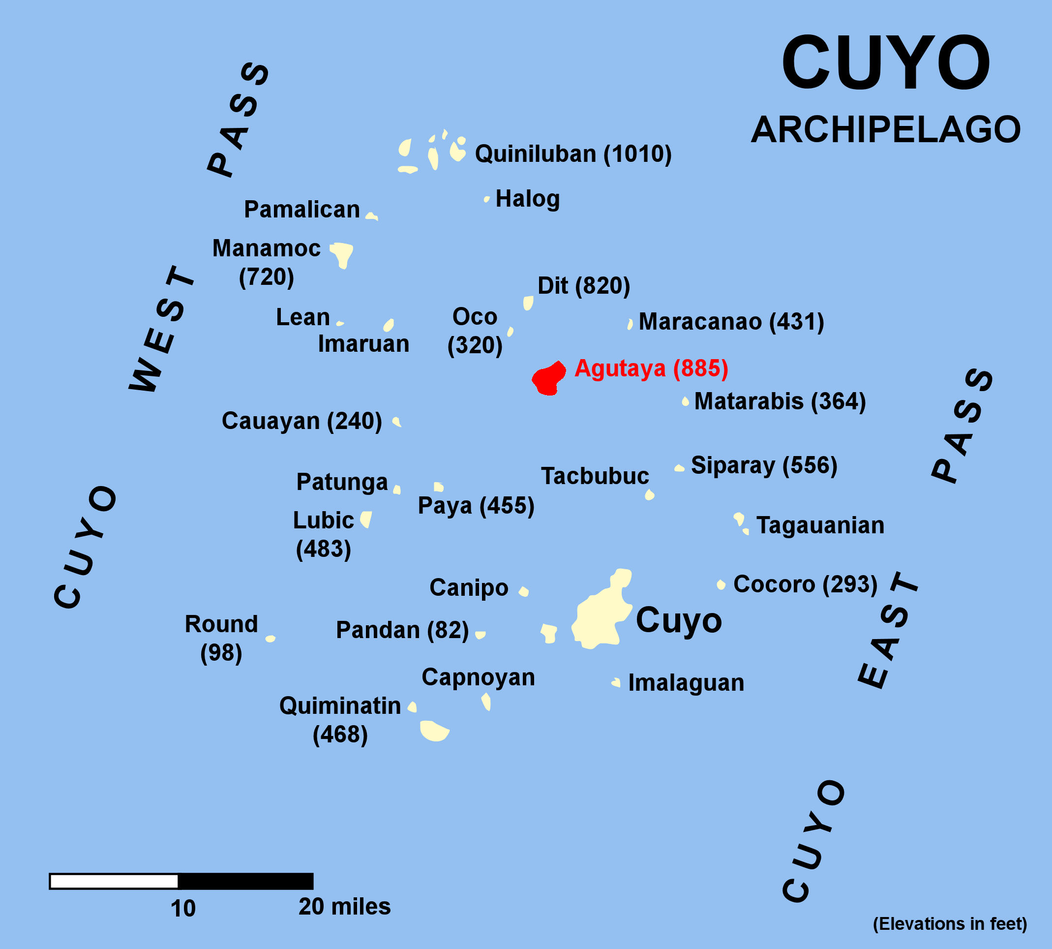

Agutaya Island is the second largest of the Cuyo group with an area of about 4.5 square miles (12 km2). The north-eastern part is hilly. Four peaks tower over the island. The middle and highest of the four peaks, 885 feet (270 m) high, is covered with cogon grass (Imperata arundinacea), the others being wooded.[5]
Native sailboats used to be unable to sail to and from the nearby island of Cuyo (only 20 miles away), due to the strength of the monsoon, either the Northwest monsoon in wintertime, or the Southwest monsoon in summer.[6]
Volcano
Agutaya is an inactive volcano, 120 metres (390 ft) ASL, located at 11°09′N 120°57′E, in the province of Palawan in the Philippines.
Philippine Institute of Volcanology and Seismology (Phivolcs) lists Agutaya as inactive.[7]
Barangays
The Municipality of Agutaya is politically subdivided into 10 barangays.
- Abagat (Poblacion)
- Algeciras
- Bangcal (Poblacion)
- Cambian (Poblacion)
- Concepcion
- Diit
- Maracañao
- Matarawis
- Villa Fria
- Villa Sol
Climate
| Climate data for Agutaya, Palawan | |||||||||||||
|---|---|---|---|---|---|---|---|---|---|---|---|---|---|
| Month | Jan | Feb | Mar | Apr | May | Jun | Jul | Aug | Sep | Oct | Nov | Dec | Year |
| Average high °C (°F) | 29 (84) |
30 (86) |
30 (86) |
31 (88) |
31 (88) |
30 (86) |
29 (84) |
29 (84) |
29 (84) |
29 (84) |
29 (84) |
29 (84) |
30 (85) |
| Average low °C (°F) | 23 (73) |
23 (73) |
23 (73) |
24 (75) |
25 (77) |
25 (77) |
24 (75) |
24 (75) |
24 (75) |
24 (75) |
24 (75) |
24 (75) |
24 (75) |
| Average precipitation mm (inches) | 45 (1.8) |
34 (1.3) |
62 (2.4) |
64 (2.5) |
127 (5.0) |
159 (6.3) |
172 (6.8) |
147 (5.8) |
167 (6.6) |
182 (7.2) |
172 (6.8) |
88 (3.5) |
1,419 (56) |
| Average rainy days | 12.1 | 9.4 | 13.0 | 14.3 | 22.7 | 26.9 | 28.0 | 26.4 | 27.0 | 27.0 | 22.7 | 17.8 | 247.3 |
| Source: Meteoblue[8] | |||||||||||||
Demographics
|
| ||||||||||||||||||||||||||||||||||||||||||||||||
| Source: Philippine Statistics Authority [9] [10] [11][12] | |||||||||||||||||||||||||||||||||||||||||||||||||
In the 2020 census, the population of Agutaya was 12,867 people, [3] with a density of 340 inhabitants per square kilometre or 880 inhabitants per square mile.
Languages
Agutaya is home to a specific language, called the Agutaynen language, spoken by 10,000 people overall. Today, half of its speakers live in Agutaya, while the rest live in other communities of Palawan.[13] Tagalog and Cuyonon are also widely spoken.
Economy
See also
- List of inactive volcanoes in the Philippines
- List of islands of the Philippines
- List of volcanos in the Philippines
- Pacific ring of fire
References
- Municipality of Agutaya | (DILG)
- "2015 Census of Population, Report No. 3 – Population, Land Area, and Population Density" (PDF). Philippine Statistics Authority. Quezon City, Philippines. August 2016. ISSN 0117-1453. Archived (PDF) from the original on May 25, 2021. Retrieved July 16, 2021.
- Census of Population (2020). "MIMAROPA". Total Population by Province, City, Municipality and Barangay. PSA. Retrieved 8 July 2021.
- "PSA Releases the 2018 Municipal and City Level Poverty Estimates". Philippine Statistics Authority. 15 December 2021. Retrieved 22 January 2022.
- United States coast pilot, Philippine islands, Vol 2 Govt. print. off., 1921 p.35
- The Gems of the East by A. Henry Savage Landor p.66
- Philippines Institute of Volcanology and Seismology (Phivolcs) List of Inactive Volcanoes Archived 2008-12-06 at the Wayback Machine
- "Agutaya: Average Temperatures and Rainfall". Meteoblue. Retrieved 17 November 2019.
- Census of Population (2015). "Region IV-B (Mimaropa)". Total Population by Province, City, Municipality and Barangay. PSA. Retrieved 20 June 2016.
- Census of Population and Housing (2010). "Region IV-B (Mimaropa)". Total Population by Province, City, Municipality and Barangay. NSO. Retrieved 29 June 2016.
- Censuses of Population (1903–2007). "Region IV-B (Mimaropa)". Table 1. Population Enumerated in Various Censuses by Province/Highly Urbanized City: 1903 to 2007. NSO.
- "Province of Palawan". Municipality Population Data. Local Water Utilities Administration Research Division. Retrieved 17 December 2016.
- Proceedings of the seventh International Conference on Austronesian languages by Cecilia Odé, W. A. L. Stokhof, Rijksuniversiteit te Leiden. Vakgroep Talen en Culturen van Zuidoost-Azië en Oceanië, p.685
- "Poverty incidence (PI):". Philippine Statistics Authority. Retrieved 28 December 2020.
- https://psa.gov.ph/sites/default/files/NSCB_LocalPovertyPhilippines_0.pdf; publication date: 29 November 2005; publisher: Philippine Statistics Authority.
- https://psa.gov.ph/sites/default/files/2003%20SAE%20of%20poverty%20%28Full%20Report%29_1.pdf; publication date: 23 March 2009; publisher: Philippine Statistics Authority.
- https://psa.gov.ph/sites/default/files/2006%20and%202009%20City%20and%20Municipal%20Level%20Poverty%20Estimates_0_1.pdf; publication date: 3 August 2012; publisher: Philippine Statistics Authority.
- https://psa.gov.ph/sites/default/files/2012%20Municipal%20and%20City%20Level%20Poverty%20Estima7tes%20Publication%20%281%29.pdf; publication date: 31 May 2016; publisher: Philippine Statistics Authority.
- https://psa.gov.ph/sites/default/files/City%20and%20Municipal-level%20Small%20Area%20Poverty%20Estimates_%202009%2C%202012%20and%202015_0.xlsx; publication date: 10 July 2019; publisher: Philippine Statistics Authority.
- "PSA Releases the 2018 Municipal and City Level Poverty Estimates". Philippine Statistics Authority. 15 December 2021. Retrieved 22 January 2022.
External links
- Agutaya Profile at PhilAtlas.com
- Philippine Standard Geographic Code
- Philippine Census Information
- Local Governance Performance Management System
Places adjacent to Agutaya | |
|---|---|
Puerto Princesa (capital) | |
| Municipalities | |
| Highly urbanized city |
|
На других языках
[de] Agutaya
Agutaya ist eine philippinische Stadtgemeinde in der Provinz Palawan. Die Stadtgemeinde Agutaya wurde 1916 durch Erlass des Act of Congress vom 29. August 1916 gegründet, das Gebiet gehörte vorher zu Cuyo.- [en] Agutaya
Другой контент может иметь иную лицензию. Перед использованием материалов сайта WikiSort.org внимательно изучите правила лицензирования конкретных элементов наполнения сайта.
WikiSort.org - проект по пересортировке и дополнению контента Википедии