geo.wikisort.org - Island
The Cuyo Archipelago or Cuyo Islands, is a group of about 45 islands lying to the northeast of the Philippine island of Palawan.[1] It lies south of Mindoro and between Northern Palawan and Panay. It is centered on the largest island of the archipelago, Cuyo Island, with an area of 22 square miles (57 km2) and is about 9 miles (14 km) long.
 | |
 Cuyo Archipelago Location within the Philippines | |
| Geography | |
|---|---|
| Location | Sulu Sea |
| Coordinates | 10°51′N 121°01′E |
| Total islands | 45 |
| Major islands |
|
| Area | 50 sq mi (130 km2) |
| Highest elevation | 251 m (823 ft) |
| Highest point | Mount Bonbon |
| Administration | |
Philippines | |
| Region | Mimaropa |
| Province | Palawan |
| Municipality |
|
| Demographics | |
| Demonym | Cuyonon |
| Population | 48,959 (2020) |
The 45 islands and islets of the archipelago form a total land area of 50 square miles (130 km2).[2] Cuyo is divided into two island groups. To the north is the Quiniluban group. To the south is the Cuyo group, where the centers of the three municipalities namely Cuyo, Agutaya, and Magsaysay are located.
Geologically, the islands are related to the main island of Palawan. They are positioned on the western edge of the Luzon Arc.[2] Cuyo island is volcanic. The northern islands of Quiniluban seem to be uplifted coral atolls, although the heights of some of the peaks strongly suggest volcanic uplift. There have been plans before to establish the Cuyo Archipelago as a separate province from Palawan, just like what happened when Batanes became independent from Cagayan province.[2] Many other islands of the group are purely corallian.[2]
Cuyo is divided in three municipalities, namely Cuyo, Agutaya, and Magsaysay:
- Cuyo, Palawan (southern and western part)
- Magsaysay, Palawan (eastern part)
- Agutaya, Palawan (northern part)
Altogether, 45,718 people inhabit the Cuyo group of islands.[3]
Some of the main islands, or island groups, are:
|
|
Islands
 Quiniluban group, northern part of the Cuyo archipelago.
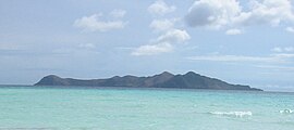 Manamoc island is located in the northwestern part of the Cuyo archipelago.
 Pamalican island.
 Agutaya island, and small Oco island in the forefront.


Notes
- Traveler's Companion Philippines 1998 p.214 Kirsten Ellis, Globe Pequot Press Globe Pequot, 1998
- The Philippine Island world: a physical, cultural, and regional geography by Frederick L. Wernstedt, Joseph Earle Spencer p.24
- "Total Population by Province, City, Municipality and Barangay: as of May 1, 2010" (PDF). 2010 Census of Population and Housing. National Statistics Office. Archived from the original (PDF) on 15 November 2012. Retrieved 7 November 2012.
External links
 Media related to Cuyo Islands at Wikimedia Commons
 Cuyo Islands travel guide from Wikivoyage
Puerto Princesa (capital) | |
| Municipalities |
|
| Highly urbanized city |
|
На других языках
[de] Cuyo-Archipel
Der Cuyo-Archipel ist eine Inselgruppe in den Philippinen. Die Gruppe von über 45 Inseln liegt östlich der Insel Palawan in der nördlichen Sulusee. Die Inselgruppe teilt die Sulusee in diesem Seegebiet in die Cuyo East und Cuyo West Passage, beides sind bedeutende Seewege für die Schifffahrt von Südostasien in die Volksrepublik China, nach Taiwan und Japan. Der komplette Archipel gehört zum Verwaltungsregion MIMAROPA. Zur Verwaltung der Inselgruppe wurden drei Stadtgemeinden eingerichtet: Cuyo, Agutaya und Magsaysay, alle der Provinz Palawan zugehörig.- [en] Cuyo Archipelago
[fr] Îles Cuyo
Les îles Cuyo sont un archipel philippin constitué d'environ 45 petites îles situées dans la mer de Sulu, au sud de Mindoro, entre la partie nord de Palawan et l'île de Panay.[it] Isole Cuyo
Le isole Cuyo sono un arcipelago che si trova nel mar di Sulu, tra l'isola di Palawan a est e l'isola di Panay a ovest. L'arcipelago ha una lunghezza di circa 80 km ed una larghezza massima di circa 60 km. La superficie totale è di circa 130 km² e la popolazione di circa 43.000 abitanti (2007). Amministrativamente appartengono alle Filippine, provincia di Palawan, suddivise fra le municipalità di Cuyo, Magsaysay e Agutaya.Другой контент может иметь иную лицензию. Перед использованием материалов сайта WikiSort.org внимательно изучите правила лицензирования конкретных элементов наполнения сайта.
WikiSort.org - проект по пересортировке и дополнению контента Википедии