geo.wikisort.org - Coast
Cape Flying Fish (72°3′S 102°20′W, also known as Cape Dart[1]) is an ice-covered cape which forms the western extremity of Thurston Island. It was discovered by Richard E. Byrd and members of the US Antarctic Program in a flight from the USS Bear in February 1940. It was named by the Advisory Committee on Antarctic Names for the United States Exploring Expedition ship USS Flying Fish, commanded by William M. Walker, which reached a point within 125 miles (201 kilometers) of this cape; the ship's position on the morning of March 23, 1839, was 70°0′S 100°16′W.[2]


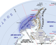
Cape Flying Fish separates the Amundsen Sea in the west from the Bellingshausen Sea in the east. It constitutes the eastern boundary of the Walgreen Coast, and the western boundary of the Eights Coast.[3]
Maps
- Thurston Island – Jones Mountains. 1:500000 Antarctica Sketch Map. US Geological Survey, 1967.
- Antarctic Digital Database (ADD). Scale 1:250000 topographic map of Antarctica. Scientific Committee on Antarctic Research (SCAR), 1993–2016.
References
- Stewart, John (1990). Antarctica: an encyclopedia. McFarland. ISBN 9780899505978.
- "Flying Fish, Cape". Geographic Names Information System. United States Geological Survey, United States Department of the Interior. Retrieved 28 March 2012.
- Sailing Directions for Antarctica: Includes Islands South of Latitude 60.̊. Defense Mapping Agency, Hydrographic Center. 1976.
![]() This article incorporates public domain material from "Flying Fish, Cape". Geographic Names Information System. United States Geological Survey.
This article incorporates public domain material from "Flying Fish, Cape". Geographic Names Information System. United States Geological Survey.
Antarctica | ||||||||
|---|---|---|---|---|---|---|---|---|
| Geography |
|  | ||||||
| History |
| |||||||
| Politics |
| |||||||
| Society |
| |||||||
| Famous explorers |
| |||||||
| ||||||||
This Thurston Island location article is a stub. You can help Wikipedia by expanding it. |
Другой контент может иметь иную лицензию. Перед использованием материалов сайта WikiSort.org внимательно изучите правила лицензирования конкретных элементов наполнения сайта.
WikiSort.org - проект по пересортировке и дополнению контента Википедии