geo.wikisort.org - Sea
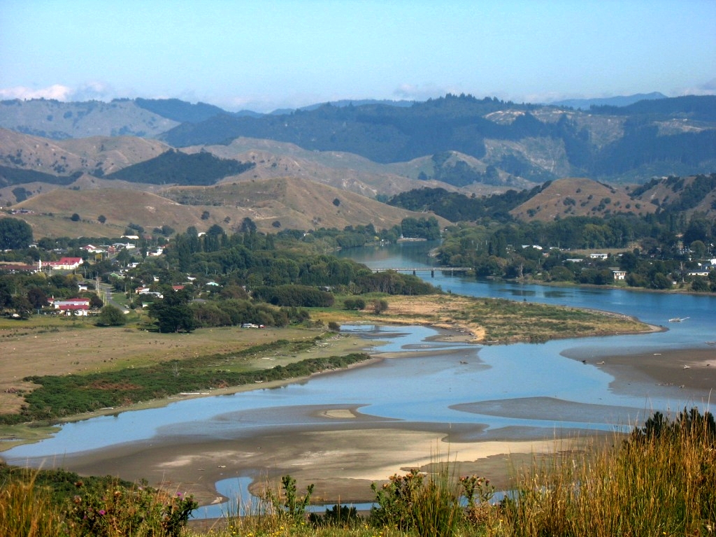
Tolaga Bay (Māori: Uawa) is both a bay and small town on the East Coast of New Zealand's North Island located 45 kilometres northeast of Gisborne and 30 kilometres south of Tokomaru Bay.
Tolaga Bay
Uawa (Māori) | |
|---|---|
Town | |
 Tolaga Bay | |
 | |
| Coordinates: 38°22′S 178°18′E | |
| Country | New Zealand |
| Territorial authority | Gisborne District |
| Ward | Uawa |
| Population (2018)[1] | |
| • Total | 811 |
| Time zone | UTC+12 (NZST) |
| • Summer (DST) | UTC+13 (NZDT) |
| Postcode | 4077 |
| Area code(s) | 06 |
The region around the bay is rugged and remote, and for many years the only access to the town was by boat. Because the bay is shallow, a long wharf – the second longest in New Zealand (600m) after the Tiwai Point wharf at Bluff (1,500m) – was built in the 1920s to accommodate visiting vessels. The last cargo ship to use the wharf loaded a cargo of maize in 1967.[2]
The town is a popular holiday spot. Its population is predominantly Māori, a centre of the Te Aitanga-a-Hauiti hapū and home of Ariki – Te Kani a Takirau[3] and Tohunga – Rangiuia.[4]
Geography
The Uawa River reaches the Pacific Ocean in the middle of Tolaga Bay. There is a bar at the river mouth with around 2 metres of water at high tide. The Uawa River is called the Hikuwai further up. Tributaries include the Waiau and the Mangaheia. In 2018 heavy rains washed huge amounts of discarded forestry timber (or slash) down the Uawa River, which choked up the estuary, covered the beach, and caused extensive damage to farms and houses.[5]
An island in the bay was originally named Spöring Island by Cook, after his expedition's assistant naturalist and instrument maker, Herman Spöring, a Finnish botanist. It is however today again known by its Māori name, Pourewa.
Parks
Uawa Reserve is the settlement's local sports ground.[6]
Demographics
The population of Tolaga Bay was 831 in the 2018 census, an increase of 84 from 2013. There were 423 males and 411 females. 26.0% of people identified as European/Pākehā, 86.6% as Māori and 4.7% as Pacific peoples. 26.4% were under 15 years old, 15.9% were 15–29, 43.3% were 30–64, and 14.4% were 65 or older.[1]
| Year | Pop. | ±% p.a. |
|---|---|---|
| 2006 | 1,914 | — |
| 2013 | 1,728 | −1.45% |
| 2018 | 1,851 | +1.38% |
| Source: [7] | ||
The statistical area of Wharekaka, which at 1,198 square kilometres is much larger than this town, had a population of 1,851 at the 2018 New Zealand census, an increase of 123 people (7.1%) since the 2013 census, and a decrease of 63 people (-3.3%) since the 2006 census. There were 660 households. There were 945 males and 906 females, giving a sex ratio of 1.04 males per female. The median age was 37.9 years (compared with 37.4 years nationally), with 465 people (25.1%) aged under 15 years, 297 (16.0%) aged 15 to 29, 867 (46.8%) aged 30 to 64, and 222 (12.0%) aged 65 or older.
Ethnicities were 49.6% European/Pākehā, 64.2% Māori, 2.9% Pacific peoples, 0.6% Asian, and 1.6% other ethnicities (totals add to more than 100% since people could identify with multiple ethnicities).
The proportion of people born overseas was 5.8%, compared with 27.1% nationally.
Although some people objected to giving their religion, 51.1% had no religion, 34.5% were Christian, 0.2% were Buddhist and 5.0% had other religions.
Of those at least 15 years old, 213 (15.4%) people had a bachelor or higher degree, and 324 (23.4%) people had no formal qualifications. The median income was $26,900, compared with $31,800 nationally. The employment status of those at least 15 was that 687 (49.6%) people were employed full-time, 219 (15.8%) were part-time, and 81 (5.8%) were unemployed.[7]
History

Tolaga Bay was named by Lt. James Cook in 1769. Described as "an obvious corruption of a Maori name", the exact derivation of the name is unclear. It may have been a misunderstanding of "teraki" or "tarakaka", referring to the local south-westerly wind rather than the place.[8][9] The original Māori name is Uawa Nui A Ruamatua (shortened to Uawa), and some local residents now refer to the area as Hauiti, and themselves as Hauitians[10] from the local hapū Te Aitanga-a-Hauiti.
At the time of Cook's visit, according to Anne Salmond, here "a famous school of learning (Known as Te Rawheoro) that specialized in tribal lore and carving was sited..." Tupaia, the Raiatean navigator accompanying Cook since Tahiti, met with the tohunga, priest, of this whare wananga. Tupaia exchanged news of the "Māori island homelands, known to Māori as 'Rangiatea' (Ra'iatea), 'Hawaiki' (Havai'i, the ancient name for Rai'iatea), and 'Tawhiti' (Tahiti)." The Māori viewed Tupaia as a tohunga, and many children born during his visit bore his name. Additionally, Tupaia made a sketch within the rock shelter of Opoutama ('Cook's Cove' or 'Tupaia's Cave'), according to Joel Polack.[11]
In the 1830s there was a thriving flax trade involving early European traders like Barnet Burns.[9] By 1998, the wharf had deteriorated and was in danger of being closed. In response, the Tolaga Bay Save the Wharf Trust raised funds and gained technical help to restore it. The wharf has now been re-opened and the refurbishment project finished in May 2013.[12]
Marae
Two marae are located south of the main township:
- Te Rawheoro Marae and Te Rawheoro meeting house is a meeting place of the Ngāti Porou hapū of Ngāti Patu Whare, Te Aitanga a Hauiti and Ngāti Wakarara.[13][14]
- Hauiti Marae and Ruakapanga meeting house is a meeting place of the Ngāti Porou hapū of Ngāi Tutekohi, Ngāti Kahukuranui and Te Aitanga a Hauiti.[13][14]
Three marae are located north of the main township:
- Puketawai Marae and Te Amowhiu meeting house is a meeting place of the Ngāti Porou hapū of Te Whānau a Te Rangipureora.[13][14]
- Hinemaurea ki Mangatuna Marae and Hinemaurea meeting house is a meeting place of Ngāti Kahukuranui, a hapū of Te Aitanga-ā-Hauiti.[13][14]
- Ōkurī Marae and meeting house is a meeting place of the Ngāti Porou hapū of Ngāti Ira and Ngāti Kahukuranui.[13][14]
In October 2020, the Government committed $5,756,639 from the Provincial Growth Fund to upgrade 29 Ngāti Porou marae, including Te Rawheoro Marae, Hauiti Marae, Puketawai Marae and Hinemaurea ki Mangatuna Marae. The funding was expected to create 205 jobs.[15]
Education
Tolaga Bay Area School is a Year 1–15 state area school[16] with a roll of 290.[17]
Te Kura Kaupapa Māori o Mangatuna is a Year 1–8 Māori immersion school[18] with a roll of 17[19]
Both schools are co-educational. Rolls are as of March 2022.[20]
References
- "Age and sex by ethnic group (grouped total response), for census usually resident population counts, 2006, 2013, and 2018 Censuses (urban rural areas)". Statistics New Zealand. Retrieved 4 January 2021.
- Tolaga Bay, a history of the Uawa District : Tolaga Bay School Centennial, 1888–1988.
- "Te Kararoa". Register of Historic Places. Heritage New Zealand. Retrieved 21 December 2009.
- "Taharangi". Register of Historic Places. Heritage New Zealand. Retrieved 21 December 2009.
- Arnold, Naomi (July–August 2018). "When the rain came for Tolaga Bay". New Zealand Geographic (152): 10–15.
- "Gisborne Parks and Reserves". gdc.govt.nz. Gisborne District Council.
- "Statistical area 1 dataset for 2018 Census". Statistics New Zealand. March 2020. Wharekaka (205200). 2018 Census place summary: Wharekaka
- A. W. Reed, A Dictionary of Maori Place Names, p 119, A. H. & A. W. Reed, Wellington 1961
- , GisborneNZ.com, accessed 6 June 2018
- (in the comments)
- Salmond, Anne (2010). Aphrodite's Island. Berkeley: University of California Press. pp. 228-230, 235, 385. ISBN 9780520261143.
- Gisborne Herald, Friday, March 08, 2013, Project to restore old wharf nears end
- "Te Kāhui Māngai directory". tkm.govt.nz. Te Puni Kōkiri.
- "Māori Maps". maorimaps.com. Te Potiki National Trust.
- "Marae Announcements" (Excel). growregions.govt.nz. Provincial Growth Fund. 9 October 2020.
- "Education Review Office Report". ero.govt.nz. Education Review Office.
- "Ministry of Education School Profile". educationcounts.govt.nz. Ministry of Education.
- "Education Review Office Report". ero.govt.nz. Education Review Office.
- "Ministry of Education School Profile". educationcounts.govt.nz. Ministry of Education.
- "New Zealand Schools Directory". New Zealand Ministry of Education. Retrieved 23 April 2022.
External links
 Media related to Tolaga Bay at Wikimedia Commons
- "Tolaga Bay History" personal site
- "Gisborne & Eastland"
- Gisborne District Council
Другой контент может иметь иную лицензию. Перед использованием материалов сайта WikiSort.org внимательно изучите правила лицензирования конкретных элементов наполнения сайта.
WikiSort.org - проект по пересортировке и дополнению контента Википедии