geo.wikisort.org - Island
Whangaokeno / East Island[1] is a small (13-hectare or 32-acre)[2] island approximately 2 km (1.2 mi) east of East Cape in the North Island of New Zealand. Reaching an elevation of 129 m (423 ft),[2] it was the original location for the East Cape Lighthouse, which was built in 1900. However, the island is prone to earthquakes and its steep cliffs cause numerous landslides. By 1920, the danger to the lighthouse was considered great enough to trigger a decision to move the lighthouse to the mainland. In 1922, the lighthouse was extinguished and relocated to its current position.
Whangaokeno (Māori) | |
|---|---|
 View of East Island from East Cape | |
| Geography | |
| Location | Gisborne Region |
| Coordinates | 37°41′28.65″S 178°34′33.10″E |
| Area | 13 ha (32 acres) |
| Highest elevation | 129 m (423 ft) |
| Administration | |
New Zealand | |
| Demographics | |
| Population | 0 |
On 10 June 2019, the name of the island was officially gazetted as Whangaokeno / East Island.[3]
The Takitimu waka landed at Whangaōkena (East Cape).
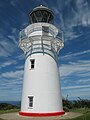 East Island was the original location of the East Cape Lighthouse.
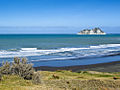 East Island seen from the bottom of the Otiki Hill


See also
- New Zealand outlying islands
- List of islands of New Zealand
- List of islands
- Desert island
References
- Also known as Motu o Kaiawa, see Kate MacIntyre, Te Whanau a Apanui and the East Coast Inquiry District, Waitangi Tribunal Scoping Report, Wai 900 #A9, p. 37.
- East Island / Whangaokeno, Rodent Invasion Project, Department of Statistics, University of Auckland. Retrieved 1 December 2009.
- "NZGB notices – June 2019". Land Information New Zealand. 25 June 2019. Retrieved 25 June 2019.
Authority control | |
|---|---|
| General |
|
| National libraries | |
This Gisborne District-related geography article is a stub. You can help Wikipedia by expanding it. |
На других языках
[de] East Island (Neuseeland)
East Island oder Whangaokeno ist eine kleine Insel zwei Kilometer östlich von East Cape vor der Nordinsel Neuseelands.- [en] Whangaokeno / East Island
Другой контент может иметь иную лицензию. Перед использованием материалов сайта WikiSort.org внимательно изучите правила лицензирования конкретных элементов наполнения сайта.
WikiSort.org - проект по пересортировке и дополнению контента Википедии