geo.wikisort.org - Sea
Blackwattle Bay is a bay located to the south–east of Glebe Island and east of Rozelle Bay on Sydney Harbour, in New South Wales, Australia. The bay was named in 1788 after the Black Wattle tree found at the bay, which was used for housing construction.
| Blackwattle Bay | |
|---|---|
 Blackwattle Bay Pontoon, Glebe | |
 Blackwattle Bay | |
| Location | Sydney Harbour, New South Wales |
| Coordinates | 33°52′21″S 151°11′20″E |
| Part of | Sydney Harbour |
| Primary outflows | Johnstons Bay |
| Basin countries | Australia |
| Settlements | Glebe |
When first used, the bay was a swampy inlet fed by a creek that ran from its eastern end. Industrial use by tanners and slaughter houses caused the area to be fouled by noxious fumes and there were many complaints by the residents.
An embankment with a bridge was built across the swamp to provide access from Glebe to Pyrmont, being known as Bridge Rd. The area to the east of the road was filled in becoming Wentworth Park.[1] A coal unloader and other facilities were built on the west side of the road and it now also features the Sydney Fish Market on its northern side.[2]
See also
- Blackwattle Bay coal wharves and depots
- Sydney Fish Market
- Wentworth Park
References
- "Pymont Bridge-road". The Evening News. No. 5373. New South Wales, Australia. 5 August 1884. p. 3. Retrieved 19 February 2017 – via National Library of Australia.
- "The Sydney Morning Herald". The Sydney Morning Herald. Vol. LXXIV, no. 11, 930. New South Wales, Australia. 14 August 1876. p. 4. Retrieved 19 February 2017 – via National Library of Australia.
Gallery
 Bellevue House at waterside end of Leichhardt Street, Glebe, which includes a cafe and restaurant
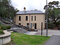 Bellevue House, Leichhardt Street Glebe at Blackwattle Bay Park
 Blackwattle Bay view from end of Cook Street, Glebe Point, across to Sydney Fish Market and Sydney CBD
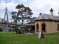
 Walter Burley Griffin historic, now re-purposed, incinerator in Sheehy Street
 View of ANZAC Bridge from dragon boat on Blackwattle Bay
 Blackwattle Bay, marina area


External links
- "The Boathouse on Blackwattle Bay".
- "Sydney Fish Market".
- Blackwattle Bay entry at dictionary of Sydney
- Part of Chippendale's grant, 1838. Cadastral drawing showing Cooper's Dam and Black Wattle Swamp.
- Birds eye view of general wharfage scheme west of Dawes Point as it will appear when completed, Sydney Harbour Trust, 1913.
Coastal bays and inlets of New South Wales, Australia | |
|---|---|
| North of Sydney Harbour |
|
| Within Sydney Harbour |
|
| South of Sydney Harbour |
|
| |
This article related to the geography of Sydney is a stub. You can help Wikipedia by expanding it. |
Другой контент может иметь иную лицензию. Перед использованием материалов сайта WikiSort.org внимательно изучите правила лицензирования конкретных элементов наполнения сайта.
WikiSort.org - проект по пересортировке и дополнению контента Википедии