geo.wikisort.org - River
The Waihou River is located in the northern North Island of New Zealand. Its former name, Thames River, was bestowed by Captain James Cook in November 1769, when he explored 14 mi (23 km) of the river from the mouth. An older Māori name was "Wai Kahou Rounga". A 1947 Geographic Board enquiry ruled that the official name would be Waihou.[1]
This article needs additional citations for verification. (September 2015) |
| Waihou River Thames River | |
|---|---|
 The Waihou River near Putāruru | |
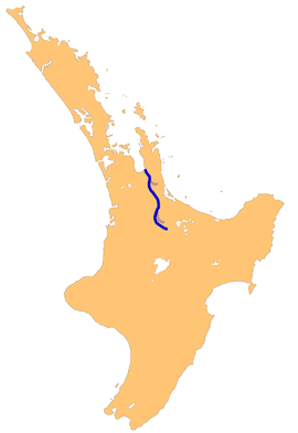 The Waihou River system | |
| Native name | Waihou (Māori) |
| Location | |
| Country | New Zealand |
| Region | Waikato |
| Physical characteristics | |
| Source | Mamaku Ranges |
| • coordinates | 38°4′34″S 176°1′52″E |
| Mouth | Firth of Thames |
• coordinates | 37°10′5″S 175°32′30″E |
• elevation | Sea level |
| Length | 150 kilometres (93 mi) |
| Basin features | |
| Tributaries | |
| • right | Ohinemuri River, Komata River, Hikutaia River, Puriri River |
| Bridges | Kopu Bridge |
Geography
The river flows north for 150 kilometres (93 mi) from the Mamaku Ranges past the towns of Putāruru, Te Aroha, Paeroa and Turua, before reaching the Firth of Thames at the south end of the Hauraki Gulf near the town of Thames. In its lower reaches, the river and the nearby Piako River form the wide alluvial Hauraki Plains. Just before the river reaches the ocean, State Highway 25 crosses the river over the Kopu Bridge, which was the longest single lane bridge in the country at 463 metres (1,519 ft) and the only remaining swing bridge on a New Zealand state highway. The bridge was infamous for the queues of vehicles travelling to and from the Coromandel Peninsula until a new two lane bridge was opened in December 2011. Tributaries include the Waimakariri Stream, Waiomou Stream, Oraka Stream and the Ohinemuri River.[2]
In 1879 the Falls of Awotonga were destroyed by 200 pounds (91 kg) of dynamite to free the navigation of the river for shipping. There was a water column of 150 m. Other parts of the river had been cleared in the same manner in previous years.[3]
In the 1910s stopbanks and floodgates were constructed along the Waihou River in order to protect farmland from flooding,[4] including a canal constructed at the point where the Waihou River and Ohinemuri River meet, west of Paeroa.[5] Further work occurred in the 1980s after extensive flooding in 1981.[4]
History
Many areas on the banks of the Waihou River were settled by Hauraki Māori, such as Oruarangi pā and Paterangi pā near Matatoki, and the Te Raupa pā and Waiwhau pā near Paeroa.[5]
Recreation
The crystal-clear waters of the Waihou River provide ideal fishing. The river supports large populations of rainbow and brown trout. A survey conducted in 2009 showed that the upper section of the river supported over 700 fish per kilometre.[2]


References
- "Waihou River". New Zealand Gazetteer.
- "Waihou River Trout Fishing". nzfishing.com. Retrieved 21 February 2013.
- "Removal Of A Waterfall By Blasting". The Cornishman. No. 49. 19 June 1879. p. 7.
- Phillips, Caroline; Green, Roger (1991). "FURTHER ARCHAEOLOGICAL INVESTIGATIONS AT THE SETTLEMENT OF WAIWHAU, HAURAKI PLAINS". Records of the Auckland Institute and Museum. 28: 147–183. ISSN 0067-0464.
- Prickett, Nigel (1990). "ARCHAEOLOGICAL EXCAVATIONS AT RAUPA: THE 1987 SEASON". Records of the Auckland Institute and Museum. 27: 73–153. ISSN 0067-0464.
External links
 Media related to Waihou River at Wikimedia Commons
- 1:50,000 map of source of Waihou River
- South Waikato District Council: Te Waihou Walkway to Blue Spring - with link to youtube video
На других языках
[de] Waihou River (Waikato)
Der Waihou River ist ein Fluss in der Region Waikato auf der Nordinsel von Neuseeland.- [en] Waihou River
[es] Río Waihou
El río Waihou se localiza en el norte de la Isla Norte de Nueva Zelanda.[it] Waihou (fiume)
Il fiume Waihou (Waihou River in inglese) è situato nel nord dell'Isola del Nord della Nuova Zelanda. Il suo nome precedente, Thames, gli venne assegnato dal capitano James Cook in onore del britannico Tamigi nel novembre 1769, anno in cui esplorò i primi 23 chilometri dal suo estuario nel Firth of Thames. Nel 1847 una commissione geografica stabilì il ripristino del nome in lingua māori, e il fiume tornò a chiamarsi Waihou.[1] Un altro e più antico nome māori del fiume è Wai Kahou Rounga.[ru] Уаихоу
Уаихоу (англ. Waihou River) — река Северного острова Новой Зеландии.Другой контент может иметь иную лицензию. Перед использованием материалов сайта WikiSort.org внимательно изучите правила лицензирования конкретных элементов наполнения сайта.
WikiSort.org - проект по пересортировке и дополнению контента Википедии