geo.wikisort.org - River
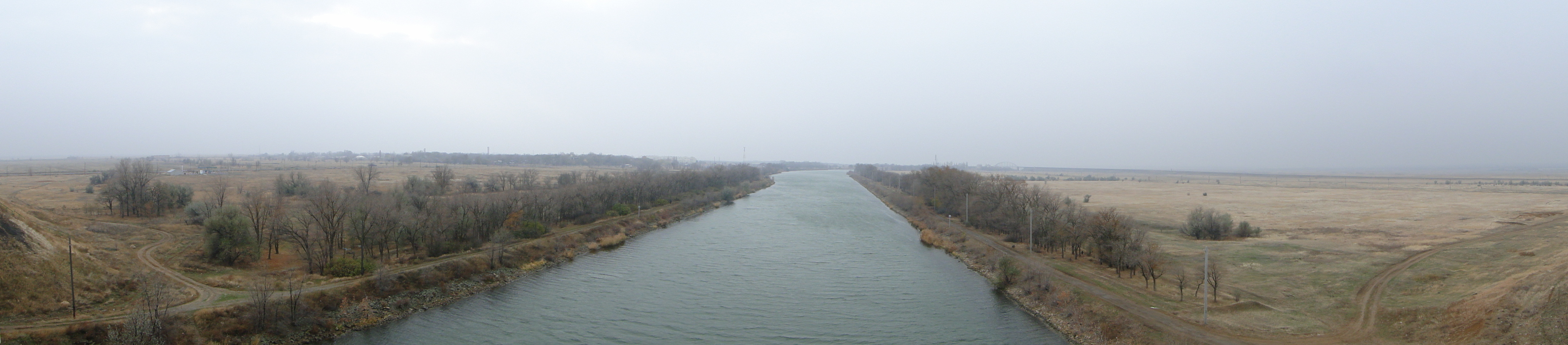
Lenin Volga–Don Shipping Canal (Russian:Волго-Донской судоходный канал имени, В. И. Ленина, Volga-Donskoy soudokhodniy kanal imeni V. I. Lenina, abbreviated ВДСК, VDSK) is a ship canal in Russia. It connects the Volga and the Don at their closest points. Opened in 1952, its length is 101 km (63 mi), 45 km (28 mi) of which is through rivers and reservoirs.
| Volga–Don Canal | |
|---|---|
 Volga–Don Canal in October 2009 | |
 | |
| Specifications | |
| Length | 63[1] miles (101 km) |
| Maximum boat length | 141 m (463 ft)[2] |
| Maximum boat beam | 16.8 m (55 ft)[2] |
| Maximum boat draft | 3.6 m (12 ft)[2] |
| Locks | 13[3] |
| Maximum height above sea level | 144 ft (44 m) |
| Status | Open |
| History | |
| Construction began | 1948 |
| Date of first use | 1 June 1952 |
| Date completed | 1952 |
| Geography | |
| Start point | Volgograd, Russia |
| End point | Tsimlyansk Reservoir, near Volgodonsk, Russia |
| Beginning coordinates | 48°37′21″N 43°32′06″E |
| Ending coordinates | 48°31′21″N 44°33′09″E |
The canal forms a part of the Unified Deep Water System of European Russia. Together with the lower Volga and the lower Don, the canal provides the shortest navigable connection between the Caspian Sea and the world's oceans, if the Mediterranean is counted, via the Sea of Azov and the Black Sea.
History
There has been a trade and military route between the Volga and Don rivers from early human history.
The existence of fortified settlement Tanais in the Don River delta, present since a time in the Bosporan Kingdom c. 438 BC– 370 AD, strongly suggests the route may have been notable enough to be fortified for more than two thousand years. The Sarkel fortress, on the near (left bank) of the lower Don, was the main control of this Volga trade route.[4]

The Don–Volga portage got its name from its trade importance 1000 years ago.[5]
In 1569, the Ottoman Empire attempted to connect the Volga and Don rivers via a canal. The Ottomans wanted to create a maritime link to Central Asia (especially the cities of Bukhara, Khwarazm and Samarkand) to facilitate trade.[6] Together with a proposed Suez canal, the Volga-Don canal would also allow Central Asian Muslims to perform pilgrimage to Mecca.[6] According to most historians, the Ottomans managed to dig one-third of the canal,[7][8] before work was abandoned due to adverse weather.[9] Other historians argue that the Ottomans merely leveled the ground so they could haul ships between the two rivers.[10] In the end, the Ottomans retreated from the area and Russia promised to respect trade and pilgrimage routes to Central Asia.[6]
The first Russian attempts to connect the Volga and Don rivers were ordered by Peter the Great.[11] After capturing Azov in 1696, he decided to build a canal, later named Petrov Val, on the Ilovlya River (a left tributary of the Don) and the Kamyshinka river (right tributary of the Volga).[12][13] Compared to the canal it was much shorter, connecting a gap of 4 kilometers (2.5 mi), but due to a lack of resources and other problems, this attempt was abandoned in 1701.[14] He initiated a second attempt (the so-called Ivanovsky Canal between Yepifan and Ivan-Ozero) under the administration of Knyaz Matvey Gagarin. However it was too shallow, as it was on the upper Don and the upper Volga via the tributaries the Oka River, the Upa River, and the Shat River in the modern Tula Oblast. Between 1702 and 1707, twenty-four locks were constructed, and in 1707, about 300 ships passed through with difficulty. In 1709 due to financial difficulties caused by the Great Northern War, the project was halted.[15]

In 1711, under the terms of the Treaty of the Pruth, Russia left Azov and Peter the Great lost all interest in the canal, which was abandoned and fell into ruin.[16][17] Over time, other projects for connecting the two rivers were proposed, but none were attempted. However, Dubovsko-Kachalinsky railway, which was horse-drawn railway and Volga–Don railway, which is now part of the South Eastern Railway were built in 1846 and 1852 respectively in order link the Volga and the Don at the shortest distance.[18] They were 68 km and 73 km long respectively.[19][20]


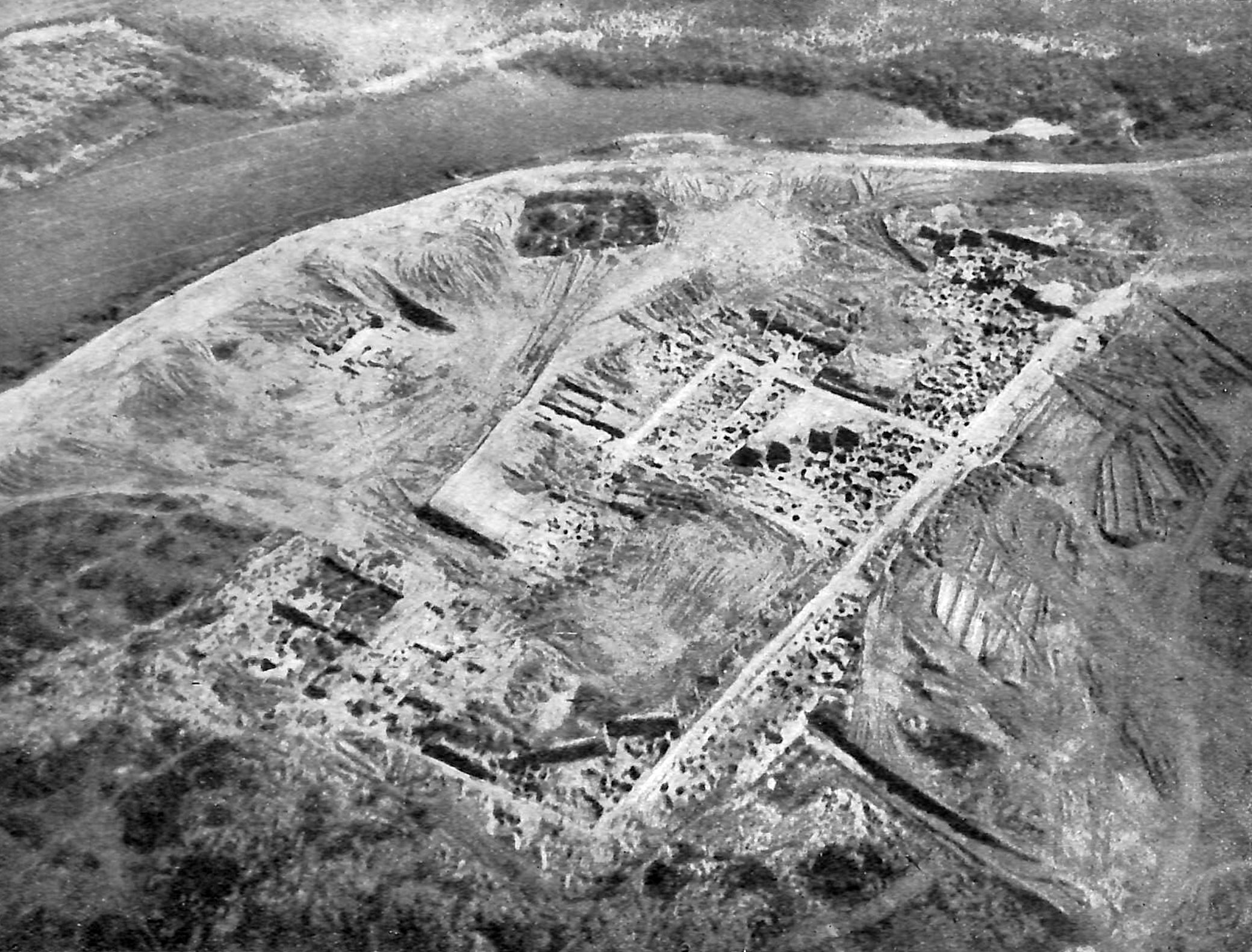
The construction of today's Volga–Don Canal, designed by Sergey Zhuk's Hydroproject Institute, began prior to the Second World War, which interrupted the process. Construction works continued from 1948 to 1952 and the canal was opened on 1 June 1952. The canal and its facilities were built by about 900,000 workers including some 100,000 German POWs and 100,000 gulag prisoners. A day spent at the construction yard was counted as three days in prison, which spurred the prisoners to work. Several convicts were even awarded the Order of the Red Banner of Labour upon their release.
Upon completion, the Volga–Don Canal became an important link in the Unified Deep Water Transportation System of the European part of the USSR.
Operation


The canal starts at the Sarepta backwater of the Volga, south of Volgograd where Lock No. 1 and the gateway arch are at 48°31′10″N 44°33′10″E. It ends in the Tsimlyansk Reservoir of the Don at the town of Kalach-na-Donu. The canal's highest elevation is the Varverovskoye (Barbarian) Reservoir between locks 9 and 10, 88 m (289 ft) above the Volga and 44 m (144 ft) above the Don rivers. It uses nine one-chamber canal locks on the Volga slope to raise/lower ships 88 m (289 ft), and four canal locks of the same kind on the Don slope that raise/lower ships 44 m (144 ft) from river height. The overall dimensions of the locks are smaller than those on the Volga River, however they can bear ships of up to 5,000 tonnes cargo capacity.
The smallest locks are 145 m (476 ft) long, 17 m (56 ft) wide, and 3.6 m (12 ft) deep. The maximum allowed vessel size is 141 m (463 ft) long, 16.8 m (55 ft) wide and 3.6 m (12 ft) deep (the Volgo–Don Max Class).[2]

The canal is filled from the Don, with three powerful pumping stations that maintain water levels. Water is also taken from the canal and used for irrigation.
Cargo transported from the Don region to the Volga include: coal from Donetsk, Ukraine, minerals (both directions), building materials, and grain. Cargo transported from the Volga to the Don includes lumber, pyrites, and petroleum products (carried mostly by Volgotanker boats).
Tourist cruisers travel in both directions.


The canal and the Tsimlyansky water-engineering system (whose chief architect was Leonid Polyakov), form part of an architectural ensemble dedicated to the battles for Tsaritsyn during the Russian Civil War and for Stalingrad during the German-Soviet War.
The Russian classical composer Sergei Prokofiev wrote the tone poem The Meeting of the Volga and the Don to celebrate its completion.
According to the Maritime Board (Morskaya Kollegiya) of the Russian government, 10.9 million tonnes of cargo were carried over the Volga–Don Canal in 2004.[21]
An alternate source claims 8.05 million tonnes of cargo was transported through the canal in 2006. Most of the cargo was moved from the east to the west: 7.20 million tonnes, and only 0.85 million tonnes the reverse. Just over half of all cargo was oil or oil products (4.14 million tonnes), predominantly shipped from the Caspian region.[22]
It was reported in 2007 that in the first 55 years of the canal's operations 450,000 vessels had passed through carrying 336 million tonnes of cargo. Recent cargo volume stood at 12 million tonnes a year.[23]
In 2016, the core of Belarusian nuclear power plant VVER-1200, which weighed 330 tonnes, was 13 meters high, and 4.5 meters in diameter, was transferred to its destination by exploiting Tsimlyansk Reservoir, the Volga–Don Canal, the Volga–Baltic Waterway, and two other connections.[24]
Stamp gallery
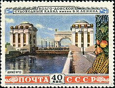 USSR stamp, 1953: Lock No. 13
 USSR stamp, 1951
 USSR stamp, 1952
 Russia Stamp 2008
 USSR collection
 Illustration of a lock on the Volga–Don Canal (1953) (47°33′5.84″N 42°08′10.26″E)


Future Options
In the 1980s, construction started on a second canal between the rivers. The new canal, dubbed Volga–Don 2 (Russian: Волго-Дон 2; 48°56′37″N 44°30′25″E) would start from the township of Yerzovka on the Volgograd Reservoir, north (upstream) of the Volga Dam, as opposed to the existing Volga–Don Canal that starts south (downstream) of the dam.[25] This would cut the number of locks that ships coming from the Volgograd Reservoir, or from any other Volga or Kama port farther north, would have to traverse on their way to the Don. The project was abruptly cancelled on 1 August 1990 to cut expenditure, by which time more than 40 percent of its funds had already been spent.[25][26][27] Since then most of the stone and metal in the abandoned canal and its locks has been looted.[28]
As of 2007–2008, Russian authorities are considering two options for increasing the throughput of navigable waterways between the Caspian basin and the Black Sea. One option, which reuses the name "Volga–Don 2", is to build a second parallel channel ("second thread") of the Volga–Don Canal, equipped with larger locks 300 metres (980 ft) long. This plan would allow for an increase in the canal's annual cargo throughput from 16.5 million tonnes to 30 million tonnes. The other option, which seems to have more support from Kazakhstan,[29] who would be either canal's major customer, is to build the so-called Eurasia Canal along a more southerly route in the Kuma–Manych Depression, some of which is the much shallower Manych Ship Canal. Needing less digging than the first option and of little use to traffic to and from the Volga, it would provide a speedier connection between the Caspian and the Sea of Azov. It would also require fewer locks than the Volga–Don, as elevations in the Kuma–Manych Depression are lower.[30]
See also
References
- Сроки работы шлюзов (Lock operation periods), from the site of the Russian Shipping Companies' Association (in Russian)
- Egorov, E. V.; I. A. Ilnytskyi; V. I. Tonyuk (2015). "Dimensional Line-up of River-sea Navigational Tankers". In Guedes Soares, Carlos; Roko Dejhalla, Dusko Pavletic (eds.). Towards Green Marine Technology and Transport. Boca Raton, Fla., US: CRC Press. p. 518. ISBN 9781315643496. Retrieved 19 May 2020.
- "Volga-Don Canal - canal, Russia". Encyclopedia Britannica. Retrieved 20 April 2018.
- Elhaik E(2020)Diverse genetic origins of medieval steppe nomad conquerors – a response to Mikheyev et al(2019).
- "CA&CC; Press AB". Archived from the original on 20 July 2009.
- Giancarlo Casale. The Ottoman Age of Exploration. pp. 135–7.
- Halil İnalcık. The Origin of the Ottoman-Russian Rivalry. pp. 79–80.
- Elvin, Mark; Liu, Cuirong; Liu, Ts'ui-Jung (13 January 1998). Sediments of Time: Environment and Society in Chinese History. p. 33. ISBN 9780521563819.
The project was abandoned when one-third complete
- Colin Imber. The Ottoman Empire, 1300-1650: The Structure of Power. p. 44.
- A. N. Kurat. "The Turkish Expedition to Astrakhan' in 1569 and the Problem of the Don-Volga Canal".
{{cite journal}}: Cite journal requires|journal=(help) - "Where is the Volga-Don Canal?". 25 April 2017.
- "Город Петров Вал (Волгоградская область)".
- Ilovlya (river in the RSFSR) // Great Soviet Encyclopedia : [in 30 vol.] / Ch. ed. A.M. Prokhorov . - 3rd ed. - M .: Soviet Encyclopedia, 1969-1978.
- Minh A. N. Historical and Geographical Dictionary of the Saratov Province / Comp. A.N. Minh. - Saratov, 1898-1902. - 5 t. - App. To the Works of the Saratov Scientific Archival Commission. - S. 383
- Milena Zolotareva (January 2019). "Environmental planning and management of waterway construction (historical experience of Russia in the 18th century and the beginning of the 19th century)" (PDF).
- Плечко Л.А.: Старинные водные пути. Сервер для туристов и путешественников Скиталец. Информационный сервер обо всех видах туризма (in Russian). Retrieved 20 April 2018.
- это... Что такое Ивановский канал?. Словари и энциклопедии на Академике (in Russian). Retrieved 20 April 2018.
- Skolkov G.S. Tsaritsyn-Stalingrad in the past . - Stalingrad: Edition of the Stalingrad island of local history, 1928. - T. The first essay, 1589-1862.
- Collection of freight surface distances of Russian railways / Comp. I.F.Sauer. - St. Petersburg: Br. Panteleev, 1893. - S. 10. - 114 p.
- Minh A.N. Dubovsko-Kachalinskaya railway // Historical and geographical dictionary of the Saratov province. - Saratov: Printing house of the provincial zemstvo, 1898. - T. 1, issue 2. - S. 276-277.
- Морская коллегия: Речной транспорт Archived 7 March 2008 at the Wayback Machine (Maritime Board: River Transport) (in Russian)
- "Взвесить все" (Supplement to the Kommersant newspaper, No. 195/P(4012), 27.10.2008 (in Russian)
- «Водный мир» для Евразии ("Eurasia's 'Water World'"; Archived 4 March 2008 at the Wayback Machine), Transport Rossii, No. 28 (472) 12 July 2007 (in Russian).
- "В Белоруссию привезли первый реактор для строящейся АЭС".
- Петр ГОДЛЕВСКИЙ, «ВОЛГО-ДОН 2» — ШАГ В БУДУЩЕЕ. «Торговая газета», номер 4-5(434—435) от 23.01.2008
- D. J. Peterson, «Troubled Lands: The Legacy of Soviet Environmental Destruction»Chapter 3
- "ВОЛГО-ДОН-II: МЫ СТРОИЛИ, СТРОИЛИ И ЧТО?" (We have been building... So what?") Журнал «Власть» (Kommersant-Vlast Magazine), No. 30, 30.07.1990 (in Russian)
- "Строительство второго Волго-Донского канала, на нужды которого в свое время было затрачено 750 миллионов рублей, было заморожено 10 лет назад. А приехавшие по призыву комсомола люди так и остались там жить." (14.11.2000)
- Nazarbayev insists on Eurasian canal construction Archived 5 May 2005 at the Wayback Machine Kazinform, 22 May 2008
- "Analysis: Russia, Kazakhs eye rival canal". United Press International. Archived from the original on 9 February 2008.
External links
Volga River | ||
|---|---|---|
| Tributaries |
|  |
| Reservoirs | ||
| Hydroelectric stations |
| |
| Canals | ||
| Cities | ||
На других языках
[de] Wolga-Don-Kanal
Der 101 km lange Wolga-Don-Kanal (Wolga-Don-Schifffahrtskanal „W. I. Lenin“) ist eine künstliche Wasserstraße in Russland (Osteuropa).- [en] Volga–Don Canal
[es] Canal Volga-Don
El canal Volga–Don (en ruso, Волго–Донской судоходный канал имени В. И. Ленина, romanizado: Volgo-Donskoy sudojodny kanal ímeni V. I. Lénina, abreviado ВДСК, VDSK) es un canal que conecta el río Volga con el río Don en sus puntos más cercanos.[it] Canale Volga-Don
Il canale navigabile Lenin Volga-Don (in russo: Волго-Донской судоходный канал имени В. И. Ленина?, alfabeto latino: Volgo-Donskoj sudochodnyj kanal imeni V. I. Lenina, abbreviato in ВДСК, alfabeto latino: VDSK), è un canale artificiale che collega i fiumi Volga e Don nel punto in cui i loro corsi si trovano alla minore distanza, lungo 101 km, 45 dei quali costituiti da corsi di piccoli fiumi (loro affluenti) e da bacini artificiali.[1][ru] Волго-Донской канал
Во́лго-Донско́й судохо́дный кана́л и́мени В. И. Ле́нина (Волго-Донской канал) — канал, соединяющий реки Волгу и Дон в месте их максимального сближения на волгодонском перешейке и одновременно обеспечивающий связь Каспийского моря с Мировым океаном. Звено единой глубоководной транспортной системы европейской части России. Построен в начале 1950-х годов, одна из Великих строек коммунизма.Другой контент может иметь иную лицензию. Перед использованием материалов сайта WikiSort.org внимательно изучите правила лицензирования конкретных элементов наполнения сайта.
WikiSort.org - проект по пересортировке и дополнению контента Википедии