geo.wikisort.org - River
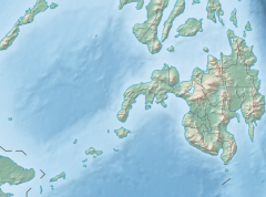
The Tagoloan River is the 13th largest river system in the Philippines in terms of watershed size, as classified by the National Water Resources Board.[1][2] It has an estimated drainage area of 1,704 square kilometres (658 sq mi) covering the provinces of Bukidnon and Misamis Oriental. It has a length of 106 kilometres (66 mi) from its source in Malaybalay City in Bukidnon province.[3]
| Tagoloan River | |
|---|---|
 Tagoloan River mouth  Tagoloan River (Philippines) | |
| Location | |
| Country | |
| Region | Northern Mindanao |
| Province |
|
| Physical characteristics | |
| Source | |
| • location | Malaybalay City, Bukidnon |
| • elevation | 2,041 ft (622 m) |
| Mouth | Macajalar Bay |
• location | Tagoloan, Misamis Oriental |
• coordinates | 8°33′20″N 124°44′37″E |
• elevation | 0 m (0 ft) |
| Length | 106 km (66 mi) |
| Basin size | 1,704 km2 (658 sq mi) |
| Discharge | |
| • location | Macajalar Bay |
| Basin features | |
| Tributaries | |
| • left |
|
| • right |
|
References
- Velasco, Luis Rey; Liborio Cabanilla (January 2003). "Assessment of Physical Resource Capability in Philippine Agriculture" (PDF). Philippine APEC Study Center Network. Archived from the original (PDF) on 2007-11-17. Retrieved 2008-09-19.
- Suminguit, Vel J.; Erlinda Burton. "§ A Study on Ancestral Domain Recognition and Management Within and Around the Mt. Kitanglad Range National Park" (PDF). ICRAF Southeast Asia. Retrieved 2008-09-19.
- Sumbalan, Antonio T. "The Bukidnon Experience on Natural Resource Management Decentralization". Archived from the original on 2011-07-19. Retrieved 2008-09-19.
На других языках
[de] Tagoloan (Fluss)
Der Tagoloan (eng.: Tagoloan River) ist ein Fluss, der in der Provinz Bukidnon und Miamis Oriental auf den Philippinen fließt. Seine Quelle entspringt in dem Tago-Gebirgszug in ca. 2000 Metern Höhe auf der Insel Mindanao. Der Fluss mündet in der Stadtgemeinde Tagoloan in die Mindanaosee. Der Tagoloan hat eine Länge von 106 km und ein Wassereinzugsgebiet von 1778 km², zu dem unter anderem die Gemeinden Impasug-ong, Manolo Fortich, Sumilao und Malitbog gezählt werden. Seine wichtigsten Nebenflüsse sind der Manolo Fortich, der Siloo, der Ipaon und der Calamuan. Diese haben ihre Quellgebiete teilweise im Kitanglad-Gebirge.- [en] Tagoloan River
Текст в блоке "Читать" взят с сайта "Википедия" и доступен по лицензии Creative Commons Attribution-ShareAlike; в отдельных случаях могут действовать дополнительные условия.
Другой контент может иметь иную лицензию. Перед использованием материалов сайта WikiSort.org внимательно изучите правила лицензирования конкретных элементов наполнения сайта.
Другой контент может иметь иную лицензию. Перед использованием материалов сайта WikiSort.org внимательно изучите правила лицензирования конкретных элементов наполнения сайта.
2019-2026
WikiSort.org - проект по пересортировке и дополнению контента Википедии
WikiSort.org - проект по пересортировке и дополнению контента Википедии