geo.wikisort.org - River
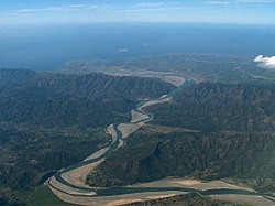
The Abra River, also called Lagben River, is the seventh largest river system in the Philippines in terms of watershed size. It has an estimated drainage area of 5,125 square kilometres (1,979 sq mi) and a length of 206 kilometres (128 mi) from its source in the vicinity of Mount Data in Benguet province.[1]
| Abra River | |
|---|---|
 | |
 Abra River mouth  Abra River (Philippines) | |
| Location | |
| Country | Philippines |
| Region |
|
| Province |
|
| Physical characteristics | |
| Source | Mount Data |
| • location | Benguet, Cordillera Administrative Region |
| • elevation | 2,310 m (7,580 ft) |
| Mouth | South China Sea |
• location | Caoayan, Ilocos Sur |
• coordinates | 17°30′47″N 120°23′45″E |
• elevation | 0 m (0 ft) |
| Length | 206 km (128 mi)[1] |
| Basin size | 5,125 km2 (1,979 sq mi)[2] |
| Discharge | |
| • average | 350 m3/s (12,000 cu ft/s) |
| Basin features | |
| Tributaries | |
| • right | Tineg River |
Geography
The Abra originates in the southern section of Mount Data. It descends westward to Cervantes, Ilocos Sur, and flows into Abra. At a point near the municipality of Dolores, it is joined by the Tineg River, which originates in the uplands of Abra.[3]
Crossings
This is listed from mouth to source.
- Quirino Bridge (
 N2 (MacArthur Highway), Santa–Bantay boundary, Ilocos Sur)
 - Old Quirino (Banaoang) Bridge (Santa–Bantay boundary, Ilocos Sur)
- Calaba Bridge (Ilocos Norte–Abra Road, Bangued)
- Don Mariano Marcos Bridge (Abra–Kalinga Road, Tayum–Dolores boundary)
- Sto. Tomas Bridge (Manabo, Abra)
- Aluling Bridge (Tagudin–Cervantes–Sabangan Road (Cervantes)
- Cervantes–Mankayan–Abatan Road (Cervantes, Ilocos Sur)
References
- Kenneth Kimutai too (July 24, 2018). "Longest Rivers In The Philippines". worldatlas.com. WorldAtlas. Retrieved September 6, 2019.
- Vicente B. Tuddao Jr. (September 21, 2011). "Water Quality Management in the Context of Basin Management: Water Quality, River Basin Management and Governance Dynamics in the Philippines" (PDF). www.wepa-db.net. Department of Environment and Natural Resources. Retrieved April 10, 2017.
- Public Information Commission, Cordillera People’s Alliance (2001). Dams in the Cordillera: The River Systems of the Cordillera and their Watersheds (PDF). Archived from the original (PDF) on August 28, 2008 – via internationalrivers.org.
External links
![]() Media related to Abra River at Wikimedia Commons
Media related to Abra River at Wikimedia Commons
На других языках
[de] Abra (Fluss)
Der Abra (eng.: Abra River) ist ein Fluss in der Provinz Abra auf den Philippinen. Er entspringt im Gebirge der Cordillera Central in der Nähe des 2187 m hohen Mount Data, in der Provinz Benguet. Nur wenige Kilometer entfernt haben auch die Flüsse Agno und der Rio Chico ihre Quellen. Der Fluss mündet in der Nähe der Gemeinde Caoayan in das Südchinesische Meer. Der Abra hat eine Länge von 181 km und ein Wassereinzugsgebiet von 5125 km².- [en] Abra River
[it] Abra (fiume)
L'Abra è un fiume delle Filippine, il sesto per grandezza del bacino idrografico, che ha un'estensione di 5125 km². La sua lunghezza è di 178 chilometri dalla sua sorgente, situata nei pressi del Monte Data, nella provincia di Benguet.Текст в блоке "Читать" взят с сайта "Википедия" и доступен по лицензии Creative Commons Attribution-ShareAlike; в отдельных случаях могут действовать дополнительные условия.
Другой контент может иметь иную лицензию. Перед использованием материалов сайта WikiSort.org внимательно изучите правила лицензирования конкретных элементов наполнения сайта.
Другой контент может иметь иную лицензию. Перед использованием материалов сайта WikiSort.org внимательно изучите правила лицензирования конкретных элементов наполнения сайта.
2019-2025
WikiSort.org - проект по пересортировке и дополнению контента Википедии
WikiSort.org - проект по пересортировке и дополнению контента Википедии